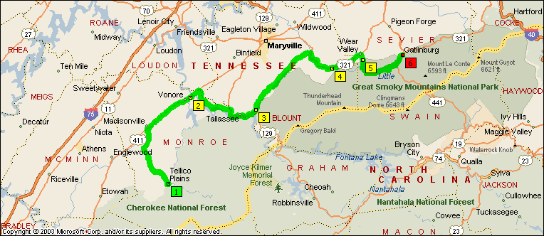
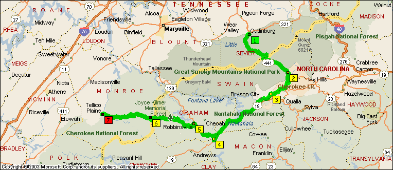
Kind of what it's going to look like when you get here...
Thanks for the pic Calabash. Can't wait to get there.
GP :yahoo:
Your welcome,
Here is a ride I have been planning for awhile and it's the same time you are visiting. Hope I run into you.
To save ink (my ink) I have written down the directions for the ride so you can print them out yourself as well as maps: I will go over this before we ride out on Saturday.
Deal @ Deals Gap #4
Riding Instructions - First Leg
1. I hope to leave Caney Creek Village at 9am on Saturday morning. We will go up hwy 360 to hwy 411 and gas up at the BP station on the right at this intersection. They have biscuits there as well as coffee if you need to grab something to eat real quick.
2. We will take hwy 411 for about 3 miles going over the Tennessee river and at hwy 72 make a right and go for about 15 miles to hwy 129 and take that for another 10 miles where we will make a left onto the foothills parkway.
3. As we go over the foothills parkway we will stop to rest and take pictures, this is about 50 miles at this point.
4. At the end of foothills parkway we’ll make a right heading into Townsend and Wear Valley. This will take us for 18 miles through the Smoky mountains along a winding river, we will stop and take pictures here as well.
5. We will come into Gatlinburg and go about 200 yards and make a right at Calhoun’s restaurant. We will have to ride back behind the stores to park and walk down to Calhoun’s. There is a gas station to fill up on the way back out. 100 miles at this point.
Riding Instructions – Second Leg
1. We will head out of Gatlinburg and slowly go up hill for about 10 miles going through two tunnels and at one point the road will circle back over itself. I read if you are going through a tunnel close one eye to get it accustomed to the dark, it seemed to work and I had on my darkened face shield. There is some construction going on at the top all the way down to the bottom. We will stop and take pictures at some point here as well. The faster riders might want to go ahead here and meet us at the bottom at the rest stop.
2. As we come down from the top we will stop at a rest area at the bottom, it is only 30 miles but all the drinks from lunch should be having an effect on your bladders at around that time.
3. We will go around the edge of Cherokee NC and get on a freeway by-passing Bryson City NC. We will go through Nantahala Gorge and will go to Hwy 129 where we will make a right and head over to Robbinsville NC. There we will stop and rest and get gas. Two hundred miles at this point.
From there we will get onto hwy 143 to get onto the Cherohala Skyway and take that for 50 miles. The faster riders might want to go ahead here and meet us at the bottom at the Bistro restaurant on the right.
Most of the ride will be curvy two lanes in which we will be riding single file. I will let you know when to ride single file and when to go back to staggered formation.
Please point out any gravel, animals, or obstacles you see for the riders behind you. Those will little experience riding with groups please ride near the rear with DeWayne and Catt who will be riding Drag.
Let’s all have a safe ride!


![fjackets Real Lambskin Leather Biker Jacket — Quilted Cafe Racer Zip Up Moto Leather Jackets For Men | [1100085] Johnson Brown, XL](https://m.media-amazon.com/images/I/41I7Pm1f+vL._SL500_.jpg)


