Planned Rides?

Yamaha FJR Motorcycle Forum

Help Support Yamaha FJR Motorcycle Forum:

This site may earn a commission from merchant affiliate links, including eBay, Amazon, and others.

quicksilver

So.., how fast does that thing go?
Joined
Jun 26, 2005
Messages
562
Reaction score
0
Location
Nashville, IN
Hey Slap,

Just thought I'd bump ya for the group.

Today is the last day I'll have access to a color printer before the EOM.

I was hoping to have pretty ride maps in my tank bag.

Are there going to be routes on the web site?

B

 
I'm wondering this too.

I'm considering just riding the parkway as much as possible and some good old fashioned exploring thrown in.

However, if there are must see roads/parks, I'm interested in hearing about them! Sounds like Shady Valley area should be explored in full???

 
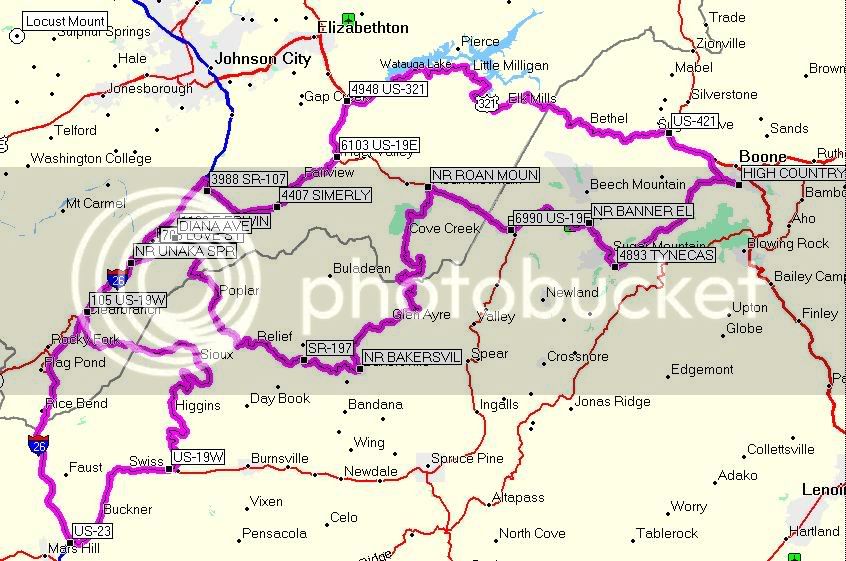
All right you guys...here is my take from SnP's white knuckle ride. Lets see if I post this correct!

1. HIGH COUNTRY 0 ft

2. Get on Hwy 105 and drive west 35 ft 35 ft 0:00:00 21° true

3. Turn right onto Nc-1107 1.2 mi 1.2 mi 0:02:11 270° true

4. Turn left onto US 321 3.2 mi 1.9 mi 0:04:52 331° true

5. US-421 6.7 mi 3.5 mi 0:05:07 95° true

6. Get on US 321 and drive northwest 6.7 mi 3 ft 0:00:00 275° true

7. Turn left onto US 321 30.4 mi 23.7 mi 0:31:29 279° true

8. 4948 US-321 40.0 mi 9.6 mi 0:13:58 250° true

9. Get on US 321 and drive west 40.0 mi 12 ft 0:00:00 70° true

10. Turn left onto Veterans Memorial Pky 40.0 mi 63 ft 0:00:03 270° true

11. 6103 US-19E 44.5 mi 4.5 mi 0:06:31 57° true

12. Get on Simerly Creek Rd and drive southwest 44.5 mi 12 ft 0:00:00 237° true

13. 4407 SIMERLY 51.0 mi 6.5 mi 0:11:14 14° true

14. Get on Hwy 107 and drive west 51.0 mi 4 ft 0:00:00 194° true

15. 3988 SR-107 56.5 mi 5.6 mi 0:09:44 168° true

16. Get on Hwy 173 and drive north 56.5 mi 6 ft 0:00:00 348° true

17. Turn left onto Hwy 173 57.2 mi 0.7 mi 0:01:17 4° true

18. Take the I-26 E/Tn-36 S/US-19w S/US-23 S ramp to the left 57.6 mi 0.4 mi 0:01:08 300° true

19. Take exit 15 to the right onto Jackson-Love Highway 65.4 mi 7.8 mi 0:08:39 218° true

20. Turn left onto Jackson Love Hwy 65.6 mi 0.2 mi 0:00:25 215° true

21. NR UNAKA SPR 65.8 mi 0.2 mi 0:00:45 90° true

22. Get on Jackson Love Hwy and drive west 65.8 mi 12 ft 0:00:00 270° true

23. Take the I-26 E/US-19w S/US-23 S ramp to the left 66.0 mi 0.2 mi 0:00:18 260° true

24. Continue on I-26 E ramp 66.1 mi 0.1 mi 0:00:29 182° true

25. Take exit 12 to the right onto US-19w towards Tn-352/Temple Hill Rd 69.4 mi 3.3 mi 0:03:30 227° true

26. Turn left onto US 19w 69.7 mi 0.3 mi 0:00:27 241° true

27. Turn right onto US 19w 69.8 mi 0.1 mi 0:00:37 153° true

28. Keep left onto US 19w 70.9 mi 1.1 mi 0:01:51 212° true

29. Turn right onto US 19w 98.9 mi 28.0 mi 0:37:05 167° true

30. US-19W 99.3 mi 0.4 mi 0:00:17 298° true

31. Get on US 19w and drive southwest 99.3 mi 3 ft 0:00:00 118° true

32. Turn right onto US 19 99.3 mi 144 ft 0:00:03 207° true

33. US-23 110 mi 10.7 mi 0:14:51 161° true

34. Get on US 19 and drive west 110 mi 8 ft 0:00:00 341° true

35. Take the I-26 W ramp to the right 110 mi 521 ft 0:00:09 268° true

36. Take exit 12 to the right onto US-19w towards Tn-352/Temple Hill Rd 130 mi 19.7 mi 0:25:30 25° true

37. Turn right onto US 19w 130 mi 0.3 mi 0:00:28 57° true

38. Turn right onto US 19w 130 mi 194 ft 0:00:22 153° true

39. 105 US-19W 131 mi 1.1 mi 0:01:51 323° true

40. Get on US 19w and drive northeast 131 mi 5 ft 0:00:00 143° true

41. Turn left onto US 19w 132 mi 1.1 mi 0:01:27 32° true

42. Take the I-26 W/Tn-36 N/Tn-81 N/US-19w N/US-23 N ramp to the right 132 mi 194 ft 0:00:40 333° true

43. Take exit 15 to the right onto Jackson-Love Highway towards Erwin 136 mi 3.6 mi 0:04:09 46° true

44. Turn right onto Jackson Love Hwy 136 mi 0.3 mi 0:00:27 27° true

45. NR UNAKA SPR 136 mi 179 ft 0:00:23 90° true

46. Get on Jackson Love Hwy and drive east 136 mi 12 ft 0:00:00 270° true

47. Turn left onto Love St 139 mi 2.3 mi 0:04:17 18° true

48. 604 LOVE ST 139 mi 21 ft 0:00:28 210° true

49. Get on Love St and drive southeast 139 mi 3 ft 0:00:00 30° true

50. 705 LOVE ST 139 mi 0.1 mi 0:00:18 57° true

51. Get on S Mohawk Dr and drive northeast 139 mi 10 ft 0:00:00 237° true

52. DIANA AVE 140 mi 1.5 mi 0:03:43 25° true

53. Get on Diana Ave and drive northwest 140 mi 0 ft 0:00:00 205° true

54. Turn right onto E Erwin Rd 140 mi 16 ft 0:00:01 295° true

55. 1103 E ERWIN 140 mi 0.3 mi 0:01:06 242° true

56. Get on Rock Creek Rd and drive southeast 140 mi 11 ft 0:00:00 62° true

57. Turn right onto Hwy 197 151 mi 10.0 mi 0:17:34 158° true

58. Turn right onto Hwy 197 151 mi 0.7 mi 0:01:14 138° true

59. Turn right onto Hwy 197 159 mi 7.4 mi 0:12:43 118° true

60. SR-197 161 mi 1.9 mi 0:03:07 350° true

61. Get on Hwy 197 and drive southeast 161 mi 12 ft 0:00:00 170° true

62. NR BAKERSVIL 166 mi 5.6 mi 0:09:41 148° true

63. Get on Toe Cane Rd and drive northeast 166 mi 22 ft 0:00:00 328° true

64. Turn left onto Hwy 261 166 mi 37 ft 0:00:01 58° true

65. NR ROAN MOUN 192 mi 25.4 mi 0:44:22 23° true

66. Get on Veterans Memorial Pky and drive east 192 mi 13 ft 0:00:00 203° true

67. 6990 US-19E 198 mi 6.8 mi 0:09:21 218° true

68. Get on Banner Elk Hwy and drive northeast 198 mi 25 ft 0:00:00 38° true

69. NR BANNER EL 205 mi 6.9 mi 0:12:09 339° true

70. Get on Main St E and drive west 205 mi 9 ft 0:00:00 159° true

71. Turn left onto Hwy 184 205 mi 17 ft 0:00:01 248° true

72. Turn right onto Hwy 105 210 mi 4.3 mi 0:08:05 147° true

73. 4893 TYNECAS 210 mi 18 ft 0:00:28 179° true

74. Get on Hwy 105 and drive east 210 mi 2 ft 0:00:00 359° true

75. HIGH COUNTRY 222 mi 12.0 mi 0:17:40 201° true

WhiteKnuckle.jpg


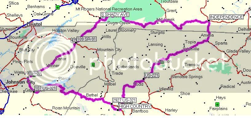
And the Long Loop to the North....

1. HIGH COUNTRY 0 ft

2. Get on Hwy 105 and drive east 35 ft 35 ft 0:00:00 21° true

3. Turn right onto US 421 1.7 mi 1.7 mi 0:03:00 0° true

4. Turn left onto Hwy 194 2.3 mi 0.6 mi 0:01:14 72° true

5. US-221 20.4 mi 18.1 mi 0:24:22 294° true

6. Get on US 221 and drive north 20.4 mi 4 ft 0:00:00 114° true

7. Turn left onto US 221 28.4 mi 8.0 mi 0:11:19 100° true

8. Turn right onto US 221 29.7 mi 1.3 mi 0:02:20 11° true

9. Turn left onto US 21 50.2 mi 20.5 mi 0:27:24 69° true

10. Turn right onto E Main St 57.4 mi 7.1 mi 0:10:43 2° true

11. INDEPENDENCE 57.4 mi 328 ft 0:00:20 173° true

12. Get on E Main St and drive west 57.4 mi 9 ft 0:00:00 353° true

13. Turn left onto Highlands Pky 74.1 mi 16.7 mi 0:22:18 310° true

14. Turn left onto Highlands Pky 87.8 mi 13.7 mi 0:18:37 270° true

15. Turn right onto US 58 91.3 mi 3.5 mi 0:04:59 240° true

16. Turn left onto Jeb Stuart Hwy 97.1 mi 5.8 mi 0:07:38 336° true

17. Keep right onto Jeb Stuart Hwy 107 mi 9.5 mi 0:13:14 250° true

18. Turn right onto Douglas Dr 107 mi 0.8 mi 0:01:09 285° true

19. Turn left onto US 58 108 mi 0.2 mi 0:00:49 354° true

20. S SHADY AVE 108 mi 0.3 mi 0:00:57 19° true

21. Get on W Laurel Ave and drive east 108 mi 5 ft 0:00:00 199° true

22. Turn right onto S Shady Ave 108 mi 17 ft 0:00:01 109° true

23. 109 SR-91 121 mi 13.3 mi 0:23:07 89° true

24. Get on Hwy 91 and drive south 121 mi 8 ft 0:00:00 269° true

25. Take the US-19e S ramp towards US-321 S 143 mi 21.7 mi 0:37:42 242° true

26. Keep right onto Broad St 143 mi 0.5 mi 0:00:48 203° true

27. Turn right onto N Main St 144 mi 0.3 mi 0:00:31 257° true

28. Turn right onto Road 144 mi 159 ft 0:00:17 351° true

29. Turn right onto East St 144 mi 399 ft 0:00:23 79° true

30. Turn left onto Broad St 144 mi 159 ft 0:00:17 171° true

31. Keep left onto Broad St 144 mi 257 ft 0:00:24 79° true

32. Turn left onto Veterans Memorial Pky 144 mi 445 ft 0:00:09 69° true

33. SR-37 144 mi 0.3 mi 0:00:26 113° true

34. Get on Veterans Memorial Pky and drive northeast 144 mi 22 ft 0:00:00 293° true

35. Perform a U-Turn back onto Veterans Memorial Pky 144 mi 0.1 mi 0:00:11 23° true

36. Turn left onto US 321 150 mi 5.6 mi 0:08:24 143° true

37. 107 US-321 150 mi 76 ft 0:00:23 250° true

38. Get on US 321 and drive east 150 mi 12 ft 0:00:00 70° true

39. Turn right onto US 321 160 mi 9.6 mi 0:13:22 69° true

40. Turn right onto US 321 183 mi 23.7 mi 0:31:54 102° true

41. 2927 US-321 187 mi 3.6 mi 0:05:13 149° true

42. Get on US 321 and drive northwest 187 mi 10 ft 0:00:00 329° true

43. Turn left onto Nc-1107 187 mi 149 ft 0:00:04 302° true

44. Turn left onto Hwy 105 189 mi 1.9 mi 0:05:12 151° true

45. HIGH COUNTRY 190 mi 1.2 mi 0:02:24 201° true

NorthLongLoop.jpg


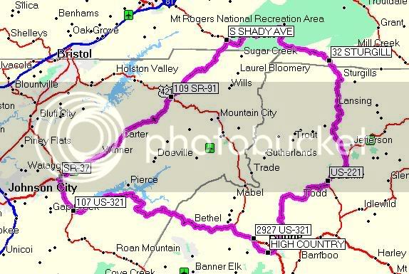
And the medium loop to the north....

1. HIGH COUNTRY 0 ft

2. Get on Hwy 105 and drive east 35 ft 35 ft 0:00:00 21° true

3. Turn right onto US 421 1.7 mi 1.7 mi 0:03:00 0° true

4. Turn left onto Hwy 194 2.3 mi 0.6 mi 0:01:14 72° true

5. US-221 20.4 mi 18.1 mi 0:24:22 294° true

6. Get on US 221 and drive north 20.4 mi 4 ft 0:00:00 114° true

7. Turn left onto US 221-Br 24.0 mi 3.6 mi 0:04:46 49° true

8. Keep left onto Hwy 194 27.1 mi 3.1 mi 0:06:04 352° true

9. Turn right onto Hwy 194 30.9 mi 3.8 mi 0:06:30 338° true

10. Turn right onto Hwy 194 34.7 mi 3.7 mi 0:06:41 9° true

11. Turn left onto Helton Creek Rd 39.5 mi 4.8 mi 0:08:36 10° true

12. 32 STURGILL 43.0 mi 3.5 mi 0:06:33 243° true

13. Get on Sturgill Rd and drive northwest 43.0 mi 20 ft 0:00:00 63° true

14. Turn left onto Highlands Pky 43.0 mi 171 ft 0:00:04 333° true

15. Turn left onto Highlands Pky 45.7 mi 2.6 mi 0:04:02 300° true

16. Turn right onto US 58 49.2 mi 3.5 mi 0:05:01 240° true

17. Turn left onto Jeb Stuart Hwy 55.0 mi 5.8 mi 0:07:41 336° true

18. Keep right onto Jeb Stuart Hwy 64.5 mi 9.5 mi 0:13:14 250° true

19. Turn right onto Douglas Dr 65.3 mi 0.8 mi 0:01:09 285° true

20. Turn left onto US 58 65.5 mi 0.2 mi 0:00:49 354° true

21. S SHADY AVE 65.8 mi 0.3 mi 0:00:57 19° true

22. Get on W Laurel Ave and drive east 65.8 mi 5 ft 0:00:00 199° true

23. Turn right onto S Shady Ave 65.8 mi 17 ft 0:00:01 109° true

24. 109 SR-91 79.1 mi 13.3 mi 0:23:07 89° true

25. Get on Hwy 91 and drive south 79.1 mi 8 ft 0:00:00 269° true

26. Take the US-19e S ramp towards US-321 S 101 mi 21.7 mi 0:37:42 242° true

27. Keep right onto Broad St 101 mi 0.5 mi 0:00:48 203° true

28. Turn right onto N Main St 102 mi 0.3 mi 0:00:31 257° true

29. Turn right onto Road 102 mi 159 ft 0:00:17 351° true

30. Turn right onto East St 102 mi 399 ft 0:00:23 79° true

31. Turn left onto Broad St 102 mi 159 ft 0:00:17 171° true

32. Keep left onto Broad St 102 mi 257 ft 0:00:24 79° true

33. Turn left onto Veterans Memorial Pky 102 mi 445 ft 0:00:09 69° true

34. SR-37 102 mi 0.3 mi 0:00:26 113° true

35. Get on Veterans Memorial Pky and drive northeast 102 mi 22 ft 0:00:00 293° true

36. Perform a U-Turn back onto Veterans Memorial Pky 102 mi 0.1 mi 0:00:11 23° true

37. Turn left onto US 321 108 mi 5.6 mi 0:08:24 143° true

38. 107 US-321 108 mi 76 ft 0:00:23 250° true

39. Get on US 321 and drive east 108 mi 12 ft 0:00:00 70° true

40. Turn right onto US 321 117 mi 9.6 mi 0:13:22 69° true

41. Turn right onto US 321 141 mi 23.7 mi 0:31:54 102° true

42. 2927 US-321 145 mi 3.6 mi 0:05:13 149° true

43. Get on US 321 and drive northwest 145 mi 10 ft 0:00:00 329° true

44. Turn left onto Nc-1107 145 mi 149 ft 0:00:04 302° true

45. Turn left onto Hwy 105 147 mi 1.9 mi 0:05:12 151° true

46. HIGH COUNTRY 148 mi 1.2 mi 0:02:24 201° true

NorthMediumLoop.jpg


Yeah, those are the main mapped routes.

I've also got a map to and from the BRP considering the current closure.

They are getting posted soon, and I'll be doing all the printing here.

I know, I know, I'm a slacker! totally..

 
Current closure?? Should I not plan on coming in on the BRP?

When I was in Boone the last week of June and jumped on the BRP going towards Cherokee I ran into a closure not that far from Boone. I would image it is still closed...correct SnP?

 
I went to the BRP website and found this:

A short section of the Blue Ridge Parkway near Blowing Rock, NC is closed for bridge repair until late September. The Sims Creek Bridge detour at Milepost 295 takes visitors only four miles off of the Parkway and is well marked

 
It's pretty much just a detour right at the boone area. From Boone, it just means knowing which entrance to shoot for depending on whether you want to go north or south on the parkway.

BTW, most of the stuff is uploading and I've just got a few details left.

 
Travis, do any of the rides hit Linville Falls area? I've been wanting to check this out. Everytime I've been on the BRP it was closed. I see it's now open.

 
Top