West Virginia...

Yamaha FJR Motorcycle Forum

Help Support Yamaha FJR Motorcycle Forum:

This site may earn a commission from merchant affiliate links, including eBay, Amazon, and others.

SPORT

Well-known member
Joined
Jun 11, 2007
Messages
1,078
Reaction score
3
Location
York, PA
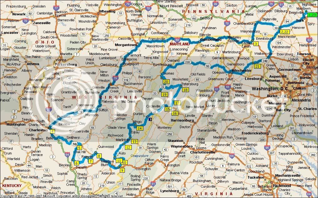
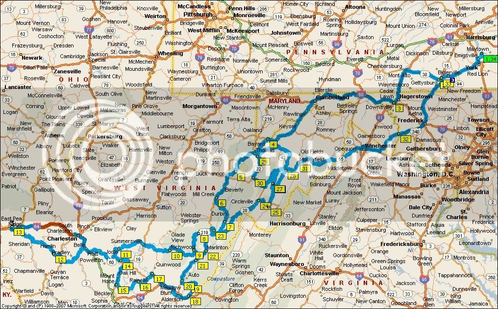
The March 2008 issue of Rider magazine featured an article about riding the North Fork mountain and the surrounding area. Nice write-up. Well, it makes from some good reading during quality time with mother nature. It just so happened that my wife read the article (strategically placed) and mentioned she will be overnighting in Charlston, WV next Saturday and asked if I wanted to join her. Jumping at the chance I have begun planning me next adventure. Approx 990 round robin miles taking slab to get there and the mountains to get home the following day. I may amend the trip to remain in the mountains both ways...haven't decided yet.

I'll be sure to take pics along the way.

A happy wife is a happy life!

 
You will love riding through the mountains....Go to the WV state.gov page and you will find a motorcycle page there.....it is new,not so sure what all is on it......they are trying to put on some maps,etc.....Charleston is our stomping grounds, give a holler if you need anything........Have a safe and smooth ride!

Sherrie, (roys better half!)

 
Here is what I'm considering:

WVRoadTrip.jpg


Last edited by a moderator:
Charleston is our stomping grounds, give a holler if you need anything!
Sherrie, (roys better half!)

Thanks for the offer. I'll keep that in mind. My wife doesn't get in until 18:30 and I've considered departing earlier and joy riding in the vicinity of Charlston. If so, you game?

 
Sport, I have traveled to Charleston many times and it is only about 25 min

longer by car to travel this route. Click this. By FJR it might be way less than

that. At point "B" you pick up slab again that's why it 's not longer time wise.

And headed home how about this route.

https://maps.google.com/maps?f=d&saddr=....015747&z=8

Now some comments on the return route.

At Upper Track, WV you can take Smoke Hole Rd. and it WILL bring you out on Rt.28

South of Petersburg, WV the mapping program shows the roads not connecting but

they do.

The other thing is in Moorefield, WV I have routed you on the old Rt. 55 which is a

better ride for motorcycles. If you want to make up time run the new Rt. 55 slab.

The time and mileage are off on this map due to the program thinking your running

some roads twice.

Also as a different route for you to look at:

https://maps.google.com/maps?f=d&saddr=....015747&z=8

On this map I routed off of I 81 onto old Rt. 11 which I think is a very scenic road. Also this

has the option of letting you jump over onto I 81 to makeup time if needed.

Hope this helps and not confuses you.

Chuck

 
Charleston is our stomping grounds, give a holler if you need anything!
Sherrie, (roys better half!)

Thanks for the offer. I'll keep that in mind. My wife doesn't get in until 18:30 and I've considered departing earlier and joy riding in the vicinity of Charlston. If so, you game?

I would love to go riding,but I already have plans with family that day......maybe next time you are in the area...... We will be at the EOM in Lewisburg. Lots of great people,fun, and crazyness there..........cant wait! See all there.......

 
Chuck,

Thanks for the options. I have begun re-routing several POI's to mimic yours. It is interesting to note that even MS Street-N-Trip 2008 does not acknowledge a a connection between north and south Smoke Hole Rd through Seneca Falls. It is a road I would like to take...if possible.

Thanks again for your insights.

Rick

 
I'm only an hour north of Charleston in Parkersburg. If you need any thing, let me know. I can be in that direction in aboot an hour.

-Dave

 
I-79 actually isn't that bad a road once you get away from Morgantown. I've only ridden it twice on cross-country runs. If you like high-speed sweepers this is a good road to ride. Did a lot of triple digit speeds, and not just gong in straight lines. I'm sure its not as crooked or as scenic as some of the other roads but I wouldn't write it off as 'slabbing it'. Its definitely not I-81.

 
Chuck,
Thanks for the options. I have begun re-routing several POI's to mimic yours. It is interesting to note that even MS Street-N-Trip 2008 does not acknowledge a a connection between north and south Smoke Hole Rd through Seneca Falls. It is a road I would like to take...if possible.

Thanks again for your insights.

Rick
SMart man listening to Chuck (hey chuck we need to ride before the summer is over). There is no sense in takin the slab all that way down to charleston. I have to say SR 20 parallels I-79 for much of your ride south and there a number of convienient outs to get on the SS if you need to make up time. I was on that route on Friday and it was in good shape, not a lot of traffic. You might also consider US Route 19 which is on the other side of 79 and is also a nice road. it will run you up to the new river gorge.

Look me up if you pass Morgantown

 
Last edited by a moderator:
Here is an updated itenerary:

WVRoadTriprevision1.jpg


I was gonna add directions to this thread, but it seemed ovwhelming and cluttered.

 
Last edited by a moderator:
SPORT....I read the same article in RIDER and I too rode some of the WV roads during our BRP trip. I didn't get to the Smoke Hole parts as the temps and time were not in our favor. I didn't find any bad roads however! I want to head back there again.

Tom

 
Sport,

I would highly recommend that instead of following 219 to Marlinton and onto Mill Point to pick up Rt 39 to Richwood that...

just north of Marlinton (between Rt 66 to Snowshoe and Marlinton) that you turn onto Rt 150 Highland Scenic Highway. It is WVs version of the BRP and brings you back out on Rt 39 east of Richwood. Cuts off a few miles, puts you right back on your route and takes you thru some of the area's most spectacular scenery with overlooks etc. Well worth it if you have never traveled that way. Don't forget your camera for this stretch.

Your Sunday route will bring you nearly by my front door, but I have been told by you know who that I have other commitments. Ride safe.

Jim

 
Spklbuk,

Points 8 & 9 are on Rt 150 (well at least half of it). #8 is Rd NF-446 (Also known as Mine Rd); #9 is Rt 150. Is NF-446 a paved road?

 
Spklbuk,
Points 8 & 9 are on Rt 150 (well at least half of it). #8 is Rd NF-446 (Also known as Mine Rd); #9 is Rt 150. Is NF-446 a paved road?

IF it is the same NF-446 that shows on my 1994 Mon Forest map off the top of Sharp's Knob near Slaty Fork, it is unimproved dirt road. NF-846 that leads up to -446 is unimproved dirt as well. If these are indeed the roads in question, they may well be gated off too. You have gone full circle...from slabbing all the way to Charleston to needing an ATV/dirt bike!

The only paved road that I can think of that comes up to 150 is CR 17 from Edray off 219 just shy of Marlinton south of where 219 and 150 intersect and while it is beautiful, it is not the most FJR friendly segment, doable, but not big bike friendly.

 
Here is a Google Map link of my intended route...for the most part. If it's possible to amend and attach those chages, that would be awesome!

Lets see if this works.

 
Last edited by a moderator:
Top