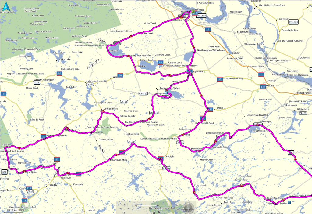
2016 CFR Routes

Yamaha FJR Motorcycle Forum

Help Support Yamaha FJR Motorcycle Forum:

This site may earn a commission from merchant affiliate links, including eBay, Amazon, and others.

yamafitter

Reigning NERDS Granite Lane Gold Medalist
Joined
Jul 16, 2008
Messages
3,096
Reaction score
1,007
Location
Bowmanville, ON
Finally got enough dirt bike stuff out of the way to actually start putting together routes for the gps.

#1 - The Poutine / River Route

The route takes you into the land of poutine and Labatts 50. We cross over the river into Quebec for a run along the river before crossing back into Ontario and working our way over to Calabogie. You can make a little detour into town on the 511 to stop in and check out the fairly new microbrewery. Back on the main route we head down one of the fun motorcycle roads in Ontario, Donald Lake Rd over to Griffith. From there we run some of the 500 series roads working our way back up to the river and end the day with a trip along the south bank.

Distance 431 km (268 miles)

Poutine - River Route GDB

Poutine - River Route GPX

 
Last edited by a moderator:
Highly recommended extensions to route one:

Each on these can be taken separately or combined

  1. From the 148 at Campbell's Bay take the 301 North to Otter Lake and 303 South which will take you back to the dam at Portage du Fort.
  2. Coming clockwise on the route from Braeside continue into Arnprior on route 1 and then take route 2 to White Lake and then the 23 to Burnstown and back on to the 508
  3. Coming clockwise on the route from Braeside continue into Arnprior on route 1, Pick up the 29 towards Almonte but then turn right on to Clayton Rd (~ 5km before you hit Almonte), turn right on route 9, turn right on route 511 and rejoin the 508 at Calabogie.
I will be running all of the above extensions if you want to tag along.

Chris

 
Highly recommended extensions to route one:Each on these can be taken separately or combined

  1. From the 148 at Campbell's Bay take the 301 North to Otter Lake and 303 South which will take you back to the dam at Portage du Fort.
  2. Coming clockwise on the route from Braeside continue into Arnprior on route 1 and then take route 2 to White Lake and then the 23 to Burnstown and back on to the 508
  3. Coming clockwise on the route from Braeside continue into Arnprior on route 1, Pick up the 29 towards Almonte but then turn right on to Clayton Rd (~ 5km before you hit Almonte), turn right on route 9, turn right on route 511 and rejoin the 508 at Calabogie.
I will be running all of the above extensions if you want to tag along.

Chris
Hey Chris how much longer are your extensions, After-all we are coming to ride
punk.gif


Highly recommended extensions to route one:Each on these can be taken separately or combined

  1. From the 148 at Campbell's Bay take the 301 North to Otter Lake and 303 South which will take you back to the dam at Portage du Fort.
  2. Coming clockwise on the route from Braeside continue into Arnprior on route 1 and then take route 2 to White Lake and then the 23 to Burnstown and back on to the 508
  3. Coming clockwise on the route from Braeside continue into Arnprior on route 1, Pick up the 29 towards Almonte but then turn right on to Clayton Rd (~ 5km before you hit Almonte), turn right on route 9, turn right on route 511 and rejoin the 508 at Calabogie.
I will be running all of the above extensions if you want to tag along.

Chris
My riding bud, Greg and I are in for the "longer ride"! Dying to see how the '16 FJR looks in person!!
bike.gif


My estimate and I am going to get flamed for this is ~ another 150 km.

For those who don't know me I estimate riding time and distances about as well as Bungie can navigate.

Note I'll be running option 1 and 3, option 2 is a alternate way to get on the 508

 
I'm working up a route that will take you over to Elephant Lake Rd and the Peterson Rd. This will definitely be a longer ride. What I'm not sure about is whether on the way back through Ompah if the Lavent Rd is paved or not.

In its current revision it runs 641 km (398 miles). This one takes you over to the west through some fun stuff to get you over to Peterson Rd at Maynooth. From there it's time to work the sides of the tires across the Peterson and down Elephant Lake Rd. Enjoy but remember you're a long way from help and you are in the Canadian Shield. There are no soft landings.

Elephant Lake Loop GDB

Elephant Lake Loop GPX

Elephant%20Lake%20Loop-XL.png


As Bill said you are a long way from help on some parts of this route and there is not a lot of cell phone coverage. Spot trackers or riding in a group highly recommended. Also fill up if you are below 1/4 tank we have been losing country store gas stations due to new tank regulations so they can be quite a distance between open pumps.

Chris

 
I dl'd the GPX files for Jim (He's riding there this weekend.) It appears the GPX files are NFG. I'm assuming everybody has been dl'ing the GDB native format files?

 
My Vasectomy reversal surgery is scheduled for June/7th, so I may need to pack some ice
wink.png
and... rough roads are not Dr. advised.

 
Last edited by a moderator:
Update, dl'd the GDB's and those are feckered as well. Can you regen the routes?

My Vasectomy reversal surgery is scheduled for June/7th, so I may need to pack some ice
wink.png
and... rough roads may be not be Dr. advised.
Ain't nobody needs to see your swollen clackers again LOL!

 
My Vasectomy reversal surgery is scheduled for June/7th, so I may need to pack some ice
wink.png
and... rough roads may be not be Dr. advised.
KJ your only going for the weekend, You don't need to pack the large sack
nono.gif


Did you get one of those I.C.E. tags from Mike? so you remember what pocket to look in
haha.gif


I dl'd the GPX files for Jim (He's riding there this weekend.) It appears the GPX files are NFG. I'm assuming everybody has been dl'ing the GDB native format files?
Odd I can get the GPX file to open in Tyre and Garmin basecamp with no issues.

 
Here is the waypoint for the diner in Wilberforce.

Wiberforce Diner

The Diner is just off the Elephant Lake Rd route. When you get to the bottom of Elephant Lake Rd at the 648 intersection near Harcourt turn right instead of left. Less than 5 miles to Wilberforce and there is also gas available in town. Highly recommended.

 
I was puttering around on the FJR today checking out the section of the Elephant Lake Loop that goes to the restaurant on Clear Lake called Moose on the Beach. The restaurant was not open and after the restaurant the road turns to gravel and goes up a fairly steep hill. It would be a nasty challenge to those without a dirt bike background so I have a new route that bypasses the restaurant and the gravel.

Latest Elephant Lake Rd Loop

 
Last edited by a moderator:
Top