I just installed Basecamp today and I found the same thing with the base map that comes with the software. When I connect my device (Nuvi 500) it switches to the map I have in the device (City Navigator North America NT 2014) and on that map, I can zoom in and see greater detail, including side streets. It does hide some of them again if I zoom out, but the closer in I go, the more detail I see.And another thing- when I set my detail to "highest" and zoom in as far as I can go, why are no small side streets shown? All I get is a blank screen. If I zoom out I can see interstates and US Hwys (major roads) but nothing else. Is this fixable? I don't want a route on major roads but it seems I have no choice....
You are using an out of date browser. It may not display this or other websites correctly.
You should upgrade or use an alternative browser.
You should upgrade or use an alternative browser.
BaseCamp "Find" feature
- Thread starter stevec677
- Start date


Help Support Yamaha FJR Motorcycle Forum:
This site may earn a commission from merchant affiliate
links, including eBay, Amazon, and others.
Nope, this does not work. I have no slider. I also do not have a scrolling mouse so that won't either.Upper left corner of the map is a Blue triangle. Put your cursor anywhere up in that corner and look for the slider to appear. Move the cursur away from that corner and the slider disappears. The slider is the zoom-in and zoom-out function, but if you have a scrolling mouse (thumbwheel) that will also zoom in and out without looking for the slider.And another thing: lesson 1, about 9 minutes in, he talks about a slider in the upper left corner of the map.
I got no slider. Where the hell is it? How do I get it to show up?
Are you saying that I have to have my gps connected to my computer in order to be able to use 2014 maps instead of 2010 maps?I just installed Basecamp today and I found the same thing with the base map that comes with the software. When I connect my device (Nuvi 500) it switches to the map I have in the device (City Navigator North America NT 2014) and on that map, I can zoom in and see greater detail, including side streets. It does hide some of them again if I zoom out, but the closer in I go, the more detail I see.And another thing- when I set my detail to "highest" and zoom in as far as I can go, why are no small side streets shown? All I get is a blank screen. If I zoom out I can see interstates and US Hwys (major roads) but nothing else. Is this fixable? I don't want a route on major roads but it seems I have no choice....
Maybe the map controls have been turned off. Set the map controls either to On or to Automatic. On will make the slider appear and stay, Automatic makes it appear when you mouse over to that corner.Nope, this does not work. I have no slider. I also do not have a scrolling mouse so that won't either.Upper left corner of the map is a Blue triangle. Put your cursor anywhere up in that corner and look for the slider to appear. Move the cursur away from that corner and the slider disappears. The slider is the zoom-in and zoom-out function, but if you have a scrolling mouse (thumbwheel) that will also zoom in and out without looking for the slider.And another thing: lesson 1, about 9 minutes in, he talks about a slider in the upper left corner of the map.
I got no slider. Where the hell is it? How do I get it to show up?
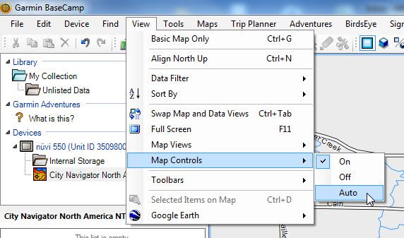
Yep, that was it.Maybe the map controls have been turned off. Set the map controls either to On or to Automatic. On will make the slider appear and stay, Automatic makes it appear when you mouse over to that corner.Nope, this does not work. I have no slider. I also do not have a scrolling mouse so that won't either.Upper left corner of the map is a Blue triangle. Put your cursor anywhere up in that corner and look for the slider to appear. Move the cursur away from that corner and the slider disappears. The slider is the zoom-in and zoom-out function, but if you have a scrolling mouse (thumbwheel) that will also zoom in and out without looking for the slider.And another thing: lesson 1, about 9 minutes in, he talks about a slider in the upper left corner of the map.
I got no slider. Where the hell is it? How do I get it to show up?
Now- next specific question:
Does anyone know what I have to do to be able to use current (newer than 2010) maps ON MY COMPUTER?
I'm given no option to UPDATE my BASECAMP 2010 maps on my computer. I am given an option to "update maps" but that is only for my device, NOT MY COMPUTER.
edit: I've searched more and cannot find any updates available for the map version usable in BaseCamp. If I connect my device to my computer and let them do their 8 to 10 minutes communication dance then I can use the 2014 maps from my DEVICE on my COMPUTER but only as long as my device is connected to my computer. Disconnect the device and BaseCamp defaults to the 2010 maps.
So, anyone have any ideas how to update BaseCamp maps to 2014?
Last edited by a moderator:
Next specific question, glossary. Does anyone know if there's a glossary of terms for BaseCamp? For instance:
- what's the difference between a "track" and a "route"
The tutorial instructor seems to use the terms interchangeably but since there's different tools I assume they're different. When planning a trip, do I want to make a track or a route and why?
- what's the difference between a "track" and a "route"
The tutorial instructor seems to use the terms interchangeably but since there's different tools I assume they're different. When planning a trip, do I want to make a track or a route and why?


$64.99
Edwards Oil Change Kit fits 2003-2020 Yamaha FJR1300 Sport Touring
Edwards Motorsports & RV's


$46.95
Harley Davidson Logo Sport Duffel (Tail of The Dragon), Black, One Size
Wisconsin Harley-Davidson


$127.99
$159.99
FLAVOR Men Brown Leather Motorcycle Jacket with Removable Hood (Large (US standard), Brown)
FLAVOR Leather


$44.99
Real Time Industries Reflective Decals for Yamaha FJR1300 Gen 2 Fairing (Black - Silver Print)
Real Time Industries


$24.37
Fuel Tank Sticker Motorcycle Stickers for Yam&aha FJR1300 FJR 1300 Tank Pad Protector Decal Emblem Side Fairing Symbol Adventure
nanyangshixianpushangmaohanggerenduzi


$22.09
$25.99
MOREOK Waterproof & Windproof -30°F Winter Gloves for Men/Women, 3M Thinsulate Thermal Gloves Touch Screen Warm Gloves for Skiing,Cycling,Motorcycle,Running-Black-XL
MOREOK-US (Ships from USA)


$15.15
$21.95
Tough Headwear Balaclava Ski Mask - Winter Face Mask for Men & Women - Cold Weather Gear for Skiing, Snowboarding & Motorcycle Riding (Black)
Tough Outfitters


$49.00
WILD HEART Waterproof Motorcycle Duffel Bag PVC500D With Rope Straps and Inner Pocket 40L 66L 100L for Kayaking, Camping, Boating,Motorcycle
ZHONGSHAN WILD FRUIT OUTDOOR

$22.09
$25.99
MOREOK Waterproof & Windproof -30°F Winter Gloves for Men/Women, 3M Thinsulate Thermal Gloves Touch Screen Warm Gloves for Skiing,Cycling,Motorcycle,Running-Black-L
MOREOK-US (Ships from USA)


$49.99
$54.99
HOOD CREW Men’s Casual Stand Collar PU Faux Leather Zip-Up Motorcycle Bomber Jacket With a Removable Hood
Jamickiki


I tried using Basecamp for a while because I thought it might have some improved features over Mapsource. If it does, they aren't features that I want or need. And keeping things organized in BaseCamp is a royal PITA.
So... I'm still happily using (obsolete) Mapsource on my (obsolete) WinXP desktop workstation and Win7 netbook when on the road. It still works wonderfully, once you've learned the User Interface.
I don't know what the errors are that are causing people to leave Mapsource. Are you talking about the crashes where it makes you exit the program? That is a little annoying but its been happening for so long now that I am just in the habit of doing frequent "saves" so I don't lose any work.
BigOgre
Well-known member
I've only switched from an "analog gps" (shout out to Jack - bbdig) recently myself. Maybe this is of some help?Next specific question, glossary. Does anyone know if there's a glossary of terms for BaseCamp? For instance:
- what's the difference between a "track" and a "route"
The tutorial instructor seems to use the terms interchangeably but since there's different tools I assume they're different. When planning a trip, do I want to make a track or a route and why?
And in ref. to updating the maps - maybe something in here?
Maybe, thanks. No use in looking at it now tho. I'm so confused and frustrated it'll have to wait.I've only switched from an "analog gps" (shout out to Jack - bbdig) recently myself. Maybe this is of some help?
Nope. The MapUpdater used there is for updating DEVICES, not COMPUTERS. The first step after opening mapUpdater is to connect your device to your computer.And in ref. to updating the maps - maybe something in here?
Just Krusen
Well-known member
Have you ever used Garmin Express to update your GPS. If not, try it. It's a free download if you do not have it. When you go to update the maps there is an option in advanced settings to install to GPS and computer. That will load the new maps to both GPS and Basecamp & Mapsource if still using it. Then you will not need to plug in the GPS every time.
I have no problem with MapSource other than it's obsolete. I have trouble blindly following my gps so when I create a route to follow:I tried using Basecamp for a while because I thought it might have some improved features over Mapsource. If it does, they aren't features that I want or need. And keeping things organized in BaseCamp is a royal PITA.
So... I'm still happily using (obsolete) Mapsource on my (obsolete) WinXP desktop workstation and Win7 netbook when on the road. It still works wonderfully, once you've learned the User Interface.
I don't know what the errors are that are causing people to leave Mapsource. Are you talking about the crashes where it makes you exit the program? That is a little annoying but its been happening for so long now that I am just in the habit of doing frequent "saves" so I don't lose any work.
- I should have up-to-date info. MapSource is too old to provide that.
- The route I create in MapSource gets changed in my gps to incorporate new roads. NOT what I want. I want my downloaded route to be my route. Simple as that. I have no way of knowing until I'm following the route and it magically, on its own, changes because of new roads.
If Garmin would have kept MapSource support without overly complicating it as they have done with BaseCamp I would happily continue to use it.
edit: disregard previous reply, I found what you're talking about. I use Garmin Express to update my device but had it set itself up to just do it automatically when I downloaded it. I had no idea it could be tweaked manually. Thanks! I'll give it a try.Have you ever used Garmin Express to update your GPS. If not, try it. It's a free download if you do not have it. When you go to update the maps there is an option in advanced settings to install to GPS and computer. That will load the new maps to both GPS and Basecamp & Mapsource if still using it. Then you will not need to plug in the GPS every time.
Last edited by a moderator:
The reason your routes are changing when you send them to your GPS is because you are not updating the maps on your computer as well as your GPS. Mapsource is not outdated, your maps are. When I send my Mapsource routes to my GPS with both running the same maps version there is no changing of the routes. The same thing would happen with Basecamp if you never update your computer's maps. By the way, when you update your computer's maps they will be available in both Mapsource and Basecamp if you have them both installed (I do)
Do not use Garmin Express. That program is a complete and utter piece of crap. It will cause the update rpocess to hang up more often than it will complete. There are more people swearing off (and swearing at) Garmin Express than Basecamp!
Use Garmin Map Updater. Yes it requires that you have your GPS connected (so it knows what maps to use), but it gives you the option to install the new maps to just your GPS device, or to just your Computer (this is what I do, and I'll tell you why in a minute) or to both your GPS and your computer.
Give me a few minutes and I'll grab some screen shots to show you where.
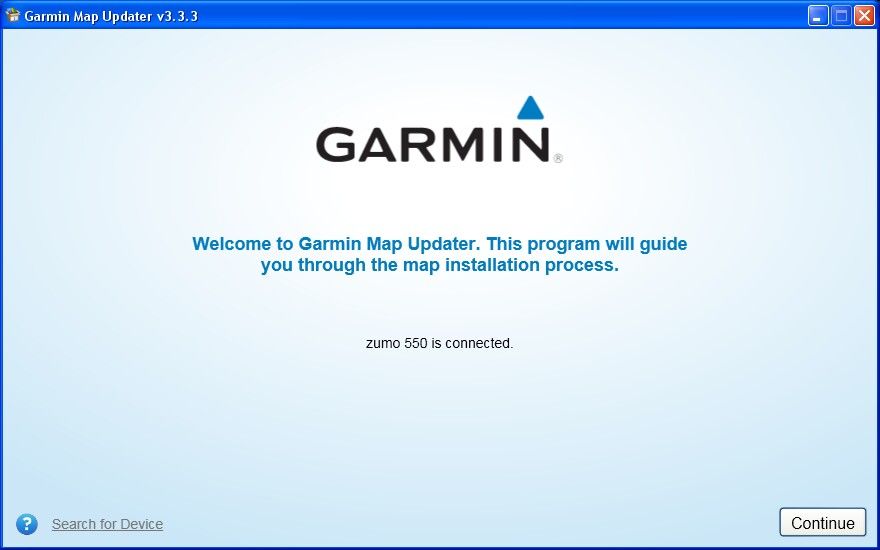
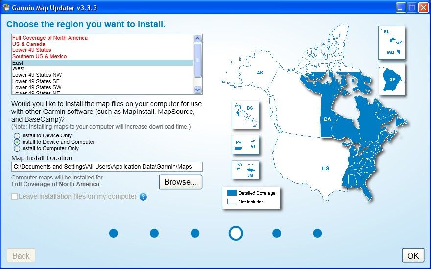
OK, here's what the screens look like in Garmin Map Updater (a free download from Garmin here).
First screen. You can see I'm running V3.3.3, which I believe is the current version available for download from Garmin. Note that you do have to have the GPS connected so it will update, even if you are going to update to the computer only
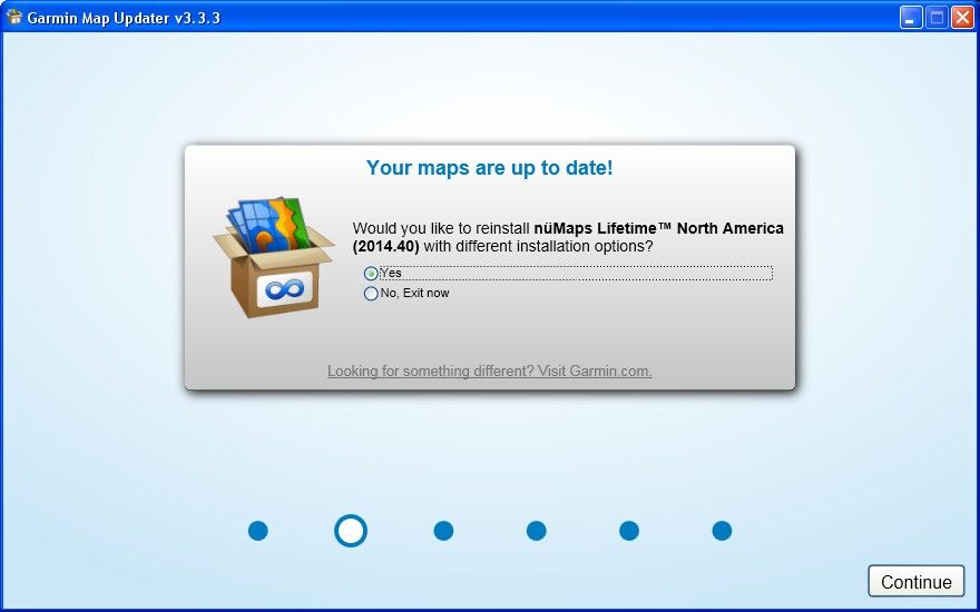
After you agree to all the legal mubo jumbo this next screen pops up. I am already up to date on the GPS and Computer, but it still gives you the option to reinstall the maps again. If your GPS maps are up to date and your computer is not, you will also see this screen.
Here's why I install my maps to the Computer only: The old zumo 550's do not have enough memory space onboard to fit the entire mapset. The lines in red are too big too fit on the GPS.
So what I do is install the entire mapset to just the computer and then use the MapInstall utility (or the utility built into Mapsource) to push the full mapset onto an 8GB SD card. If you have a zumo 66X or later you will probably not see this warning, but you will still get the option to install the maps onto both your computer and GPS device.
If you select the Install to Computer Only radio button the map zone selection goes away and it just loads the entire mapset to your computer's hard drive. I also like to change the location on the hard drive it gets installed to because my C: drive is small and I have 3 hard drives in this box.
First screen. You can see I'm running V3.3.3, which I believe is the current version available for download from Garmin. Note that you do have to have the GPS connected so it will update, even if you are going to update to the computer only
After you agree to all the legal mubo jumbo this next screen pops up. I am already up to date on the GPS and Computer, but it still gives you the option to reinstall the maps again. If your GPS maps are up to date and your computer is not, you will also see this screen.
Here's why I install my maps to the Computer only: The old zumo 550's do not have enough memory space onboard to fit the entire mapset. The lines in red are too big too fit on the GPS.
So what I do is install the entire mapset to just the computer and then use the MapInstall utility (or the utility built into Mapsource) to push the full mapset onto an 8GB SD card. If you have a zumo 66X or later you will probably not see this warning, but you will still get the option to install the maps onto both your computer and GPS device.
If you select the Install to Computer Only radio button the map zone selection goes away and it just loads the entire mapset to your computer's hard drive. I also like to change the location on the hard drive it gets installed to because my C: drive is small and I have 3 hard drives in this box.
Last edited by a moderator:
Ok Fred, I caught the first part about MapUpdater. I'm trying that to update my maps on my COMPUTER. The maps on my DEVICE are up to date.
But you lost me when you started talking about push and other utilities and such. So please stop. One step at a time. No more info. Please.
But you lost me when you started talking about push and other utilities and such. So please stop. One step at a time. No more info. Please.
Unless you are have an old zumo 450 or 550 none of that other stuff about loading on SD cards will matter to you.
RossKean
Well-known member
I have a Zumo 665 and after the most recent map update, I found that it used most of the available on-board memory. I ended out deleting all of the extra languages/voices etc and now have a bit more wiggle room. From what I can tell, if you fill the unit's basic RAM, excess stuff will go to the SD card without intervention - haven't confirmed this (on the 660 series and newer). The mapsets are getting larger so space may become an issue in the future. Maybe this is part of Garmin's strategy to get old(er) GPS units off the road. Lifetime maps are only as good as your GPS's ability to accept them. If the database is too large for your GPS, you may find that you can no longer use the update. Although "Lifetime", Garmin makes no guarantee that they will work on your older GPS. Garmin says they don't support the use of a micro SD card larger than 8gb - does anyone know if this is a system limit or just Garmin covering their ***?
Back to Basecamp - I am replacing my 10 year-old XP computer and I think I will make a fresh start with Basecamp. I'm not exactly a Mapsource guru (just the basics) so I don't have too much to unlearn. I think the video series will be very helpful even though I'm not renowned for RTFM (Reading the Fuckng Manual).
Back to Basecamp - I am replacing my 10 year-old XP computer and I think I will make a fresh start with Basecamp. I'm not exactly a Mapsource guru (just the basics) so I don't have too much to unlearn. I think the video series will be very helpful even though I'm not renowned for RTFM (Reading the Fuckng Manual).
Last edited by a moderator:
Nope. That would make too much sense, but it treats the SD card as a separate logical device, not an extension of the main memory.From what I can tell, if you fill the unit's basic RAM, excess stuff will go to the SD card without intervention - haven't confirmed this (on the 660 series and newer).
Not true. You just have to learn how to put your maps onto an SD card, which can be plenty big enough to store everything you want and more. Once you put the maps on the sd card the GPS will use those maps just as if they were installed in the device memory. No difference at all.The mapsets are getting larger so space may become an issue in the future. Maybe this is part of Garmin's strategy to get old(er) GPS units off the road. Lifetime maps are only as good as your GPS's ability to accept them. If the database is too large for your GPS, you may find that you can no longer use the update. Although "Lifetime", Garmin makes no guarantee that they will work on your older GPS.
You could do that (installing the full maps on the SD card) on a zumo 66X the same way we have to do it (to get all of the maps) on the zumo 550. I posted that process here and keep a copy of it here for posterity.

Last edited by a moderator:
RossKean
Well-known member
I guess that's a bridge I will cross when I come to it. At least for now, the base memory is sufficient with a couple hundred megs to spare after I got rid of the "extra" languages. I have no doubt that I will need more room in a year or two as mapsets continue to grow and I have more routes, trip tracks etc. on there. I realize there is no reason to keep routes beyond the current trip, but I tend to be lazy and don't delete until I have to. (Relative to the database, I suspect routes are small. Trip tracks, on the other hand, may have a lot of associated data.)
@ rbentnail, don't read any of this.

Ross, there is one other way to keep your old GPS (yeah the zumo 665 is now "old") maps up to date, and that is to just partial load your local area segments to the device itself when you do the map update. It will still (always) load the entire map set to your PC, so if you later decide to go on a big trip, you can then push the parts of the map that you didn't previously load to the GPS onto an SD card using the same techniques I linked to above. Kind of a "split maps" approach.
This is probably an adequate solution for the vast majority of us who do not participate in nation-wide rallies and such since, using you as an example, living in the far NE corner of the continent, how often do you really need those far western maps anyway? And when you do you can just load them to the SD card before you go.
As for clearing the track logs, I'm in the habit of clearing those regularly. I just use mapsource (Basecamp will do it too) to pull the tracks along with the waypoints and routes I used for the tracks off of the GPS and then save them to a folder on my PC's hard drive (called GPS Tracks) with a filename that includes the date and will remind me of what that tracklog was. Once I have saved them to the PC I can go into User Data and clear the GPS of all tracks, which does free up a lot of space.
You may not realize it but after a while the GPS actually "archives" the old track logs into an archive folder on your GPS. Once it has been archived it no longer shows up as a blue line on your screen, so those old tracks are just taking up space unnecessarily.
Similar threads
- Replies
- 16
- Views
- 2K