Creating a Waypoint by waypoint road map

Yamaha FJR Motorcycle Forum

Help Support Yamaha FJR Motorcycle Forum:

This site may earn a commission from merchant affiliate links, including eBay, Amazon, and others.

SPORT

Well-known member
Joined
Jun 11, 2007
Messages
1,078
Reaction score
3
Location
York, PA
I've discovered the power of printing/transferring road maps to others who want to join.

As such, I have been attempting to create a number of "Loops" I ride, on various software programs and have discovered that most programs are designed for only Point A to Point B trips. Programs such as Garmin Maps, Mapquest, Live Maps and several others, though allow me to create various Waypoints and even driving directions to that way point, do not connect ALL way points into a single save-able round-robin trip. Also too, if there are specific roads/detours I'd like to take I'm unable to make the software program plot those roads.

In addition to the Round Robin ability I'd like to be able to Snap-To-Grid various roads between each Waypoint. this would allow me to take those detours that so many of us long for.

Anybody here know of such a program? Can the Garmin Zumo 550 do this?

Thanks for your insights.

 
Last edited by a moderator:
I think I can make my Microsoft Streets and Trips do all the things you described....and more. It is an indispensable product for me in rallies like the Iron Butt Rally or if I'm going to plan a ride.

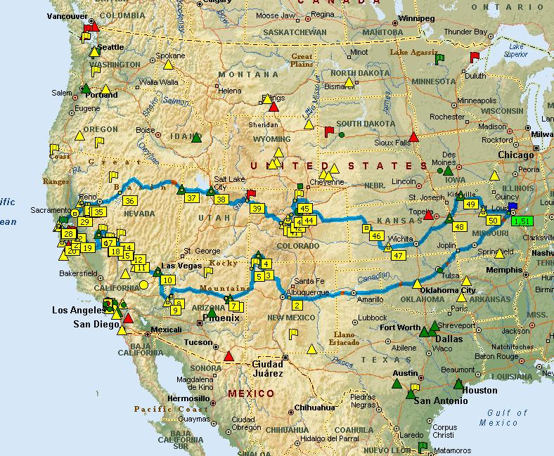
Here's an example of a largish loop I rode in Leg 2. The icons not on the route (called pushpins) remained available so I was able to easily change the route as I road it and accomodate bonus restrictions, weather, time constraints, and other variables.

leg2final.JPG


Or another one where the software automatically figured out the optimal route for visiting 39 county seats in a combination of shortest miles and time from a particular starting and ending point.

39countiesroute3.JPG


I then use another program, GPSU, to transfer the S&T route to my Garmin.

 
Last edited by a moderator:
I think I can make my Microsoft Streets and Trips do all the things you described....and more. It is an indispensable product for me in rallies like the Iron Butt Rally or if I'm going to plan a ride.
Here's an example of a largish loop I rode in Leg 2. The icons not on the route (called pushpins) remained available so I was able to easily change the route as I road it and accomodate bonus restrictions, weather, time constraints, and other variables.

leg2final.JPG


Or another one where the software automatically figured out the optimal route for visiting 39 county seats in a combination of shortest miles and time from a particular starting and ending point.

39countiesroute3.JPG


I then use another program, GPSU, to transfer the S&T route to my Garmin.
I'll look into MS Street & Trips. Unable to access your jpg's. Can you fix that?

Thanks

 
Unable to access your jpg's. Can you fix that?
I'm not sure I understand. If you can see them...that's all there is. They're just images.

If you can't see them...they're hosted on my web site and nobody has ever reported having problems seeing images before. It's possible some corporate firewalls might block access. Dunno?

 
Last edited by a moderator:
This is not as good as what you are asking for, but with Garmin's Mapsource you can create a route with the minimal set of waypoints and add as many other waypoints as you like to the file. That way you can simply select any of the waypoints to visit and then let the Garmin recalculate to get you back on your original route. The advantage of this is that you can make decisions dynamically as you ride and you don't need the laptop. A printed map on the top of your tankbag with all of the waypoints marked on it make it easy to see what points are nearby at any point in time.

 
Unable to access your jpg's. Can you fix that?
I'm not sure I understand. If you can see them...that's all there is. They're just images.

If you can't see them...they're hosted on my web site and nobody has ever reported having problems seeing images before. It's possible some corporate firewalls might block access. Dunno?
Must be my work's network blocking it. I'll check it when I get home.

It is ironic that I've seen some images from work that were less acceptable than a map...go figure.

 
Can the Microsoft Streets and Trips transfer the road trip to a Garmin C330?

 
DeLorme Street Atlas can do waypoint routes (it calls then "via") and will export routes to Garmin NMEA format, as well as its own handheld format for Palm or PocketPC/Windows Mobile.

I've been using it for years for the car with my laptop, iPAQ, and smartphone, although I don't yet have a Garmin device on the bike.

What I have for GPS with it in the car is a Bluetooth GPS antenna. My laptop, iPAQ and phone can all use it (not simultaneously). The program on both the laptop and the hendhelds gives onscreen directions, and audible turn directions through the device's speaker, but not over Bluetooth. Works great in the car, would work on the bike if I broke down and got me a Garmin to export routes to.

I don't have DeLorme's GPS receiver, I have a much less expensive Holux device I got on fleabay.

 
Last edited by a moderator:
I'm familiar with creating multiple Waypoints/via/POI's.

Lets see if I can clarify what I mean by 'Snap-to-grid'.

Lets say I have two way points that are 100 miles apart. Normally the Map's program will automatically plot a course based on some determinants (such as, avoid freeways, tolls, or the like). Now lets say that the plotted course does not take certain roads I'd like to travel on. I would like to be able to drag and drop that line of travel and have the program snap-to-grid on roads that follow near my 'drop'. It would be even cooler if I can drag smaller portions (say between turns) within two waypoints to take a road or two that might be out od the way.

I would then like the freedom to customize ALL lines of travel between EVERY waypoint.

Does this make any since? Will any of the programs allow such mapping?

 
Last edited by a moderator:
Just found that Yahoo Local Maps does something like what I'm looking for, albiet crudely. And it does not allow me to save and/or transfer either.

 
Last edited by a moderator:
I would then like the freedom to customize ALL lines of travel between EVERY waypoint.
Does this make any since? Will any of the programs allow such mapping?
The latest Google maps, of course, has just such a design. Now if only the stand-alone mapping programs would get up to speed! :glare:

 
Can the Microsoft Streets and Trips transfer the road trip to a Garmin C330?
Already answered at the bottom of post #2. Streets and trips doesn't natively support downloading to GPS units.

I thought that's what you were stating, just wanted to be sure I shared my thoughts accurately.

I'll also look at Google Maps too...at least until I can get a copy of MS Maps.

Thanks

 
I'm familiar with creating multiple Waypoints/via/POI's.
Lets see if I can clarify what I mean by 'Snap-to-grid'.

Lets say I have two way points that are 100 miles apart. Normally the Map's program will automatically plot a course based on some determinants (such as, avoid freeways, tolls, or the like). Now lets say that the plotted course does not take certain roads I'd like to travel on. I would like to be able to drag and drop that line of travel and have the program snap-to-grid on roads that follow near my 'drop'. It would be even cooler if I can drag smaller portions (say between turns) within two waypoints to take a road or two that might be out od the way.

I would then like the freedom to customize ALL lines of travel between EVERY waypoint.

Does this make any since? Will any of the programs allow such mapping?
Didn't understand that at all from your question, sorry. You want to grab the route line and drop it somewhere, creating a new waypoint in the process. That would be cool.

Now that you mention it, I'd like that, too. I basically just have to add a bunch of via points into the turn list to get that effect.

 
I build everything in MS Streets&Trips 2006 and use POI Converter shareware to convert to GPX format. Then suck it into MapSource, do a little cleanup and push it to the Zumo.

Like Iggy said, MS S&T is the routing bomb!

 
Google maps does what you're asking for. However I'm unaware of a way to download Google routes to your GPS. Mapsource does what your asking for also. You can build a base route, add "vias" to get specific points, then you can drag the route to specific roads. Once your're all done you can download the route to your GPS. You'd have to check into your specific GPS, but it works great on my Garman 2610. B)

 
Google maps does everything you want, but I have never been able to save the entire trip as a file. Anybody had any success at storing and retrieving your extensively plotted course?
It wasn't immediately obvious to me how to "save" a google map for later retrieval, but here's one way that works.

Toward the upper right edge of the map proper is a "Send" icon. This allows you to send your route as a URL in an email message. Later, you can retrieve this exact routing by clicking on the URL in the message you sent to yourself. Seems clunky, but it does gives you a permanent record of your route and you can share it with your friends.

Now, if only someone clever would come up with a way to convert the routing information embedded in that URL to a file format that one's GPS could understand... :rolleyes:

 
Top