Doing more with your GPS

Yamaha FJR Motorcycle Forum

Help Support Yamaha FJR Motorcycle Forum:

This site may earn a commission from merchant affiliate links, including eBay, Amazon, and others.
+1 Fred,

I am desperately looking forward to the next installment. I could of used this info before my Montreal --> Blueridge Parkway / Tail of the Dragon / Cherohala Skyway trip last June. But I am looking forward to the POI info for my upcoming trip to Italy in late September (no ... no by motorcycle). I plan on trying to condense your technical information into a PDF tech Tip document for easier sharing. Thanks again:

Rheal

+1 Fred. Thanks for sharing. I am looking forward to the next installments. I would like to get my hands on the FJR Dealers POI and learn how to manage Custom POI files.

On my last trip I used Find Fuel along my current route in remote locations like Utah. If more than 3 gas stations pop up in one city it is a sure bet to find gas in that city.


At least on my Zumo 550, you need have 2 differently named POI lists in the Zumo before the multiple options appear on the Zumo screen. Just one list = just one list displayed. Another mystery of life solved.!

Thanks Fred, great write up!

 
A lot of us own and use some pretty fancy Garmin GPSes on our FJRs. These units are darned sophisticated devices, and some of us can be a bit intimidated by the technology. My objective in this thread is to show you one way that you can make your GPS work harder for you when you are out on the road, by using POI files. By the way, POI stands for "Point Of Interest". So these could be any sort of a place that you would be interested in finding. I'll be demonstrating this on a zumo 550 GPS but it applies (with just minor variations) on many other Garmin GPS units.

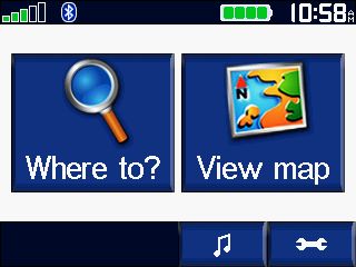
We all know how to find the closest services (fuel, food lodging, etc.) just by pressing the "Where To" button on the Top Menu screen. It's pretty intuitive,m espcecially if you've ever used a simple automotive GPS. That's pretty much the only mode those type of units will operate in.

86.jpg


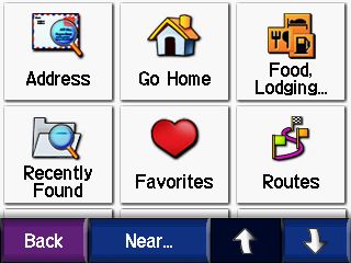
Then select the "Food, Lodging..." button on the upper right

102.jpg


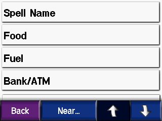
And drill down to the category of POI we are interested in

109.jpg


This will allow you to find any of the POIs that are included in your current mapset. The older your maps version is, the more outdated the POIs will be. The POIs actually change much more often than the roads do.

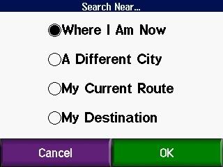
But, did you know that you can also find the nearest POIs along your currently running route? Or the ones closest to your current route's final destination? Or even tell it a completely different city from where you are currently? To do that, you just press the "Near" button on the bottom of the last screen shot above, which brings you to this screen:

85.jpg


After selecting a different option and pressing OK, the POIs will subsequently be sorted based on their proximity to your new selection rather than Where I Am Now location. "My Current Route" can be really handy if your looking for gas or food and don't want to have to stray too far. Or "My Destination" is good for looking for hotels at the end of the day. "A Different City" is most useful if you already know a place exists and you know the name of the city/town it's in.

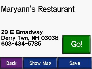
Once you find a POI that you like you can then save it for future reference by selecting the "Save" button at the lower right of the POI screen before you press "Go." It then gets added to your "Favorites" list.

315.jpg


So that is how you can find the POIs that exist in your mapset. But that POI database, though fairly extensive, is not complete. There are some that are missing and many types of POIs that are not included at all, so that is where "Custom POIs" come in.

Custom POIs are just what they seem to be, a list of your own locations that you add to the GPS. They can be any category of locations that you might find useful. For instance, on my GPS I have custom POI files for all of the Yamaha Dealerships in the US and Canada, and also one with the FJR Assist list in it. Those could obviously come in quite handy when away on a trip. I also have one for all of the Covered Bridges in New Hampshire and another for Vermont, a file with all of the Lighthouses on the entire East Coast, one with all the State Parks in New Hampshire, a file with Free Wi-Fi locations throughout the US (mostly restaurants), another file with all of the New Hampshire State Liquor Store locations, and even the new file we are compiling in the NERDS Ride To Eat List thread.

But wait, you say... Why have the NERDS Ride To Eat restaurant list in a Custom POI file? Aren't all of those restaurants already in the mapset's POIs? Well, most are. But there have been quite a few that were not, and I've had to create the POIs from scratch using an address gleaned off of a Google search.

But there is an even bigger technical reason to keep these lists as Custom POI files rather than as saved "Favorites" and that is to keep your "Favorites" list less cluttered and more manageable. There are 57 NH Covered Bridges, 118 VT covered bridges, 67 NH State Parks, 77 State Liquor Stores, 502 in the FJR Assist List, 1090 Lighthouses, 283 Yamaha Dealerships in Canada, and 1371 in the US, and, get this... 69,043 free WiFi locations in the US in my Custom POI files. And we are already up to 62 locations right now (and growing) in the NERDS RTE list. Can you imagine trying to keep all of that in your "Favorites?" No way!

Well, obviously I did not plot and create all of those custom POI files myself. I mean, I don't have much of a life, but plotting out 69 thousand free wi-fi locations is a bit bigger task than even I am up for. No, no... these files can be downloaded and saved (for free). Or, as in the case of the NERDS RTE list, you can create your own.

In the next post I'll tell you how to do both.
Fred....Just awsome! I've gotten more info from your effert than i did on the Garmin site!!!!!

 
Great write up Fred! :clapping:

I've found Zumo Forums to be a very friendly place to learn more. Garmin is not supporting Map Source anymore. They have a free product call Basecamp now. When I started using it I thought it was crap as I was used to MS Streets & Trips, but after spending the time to learn it I've found it to be very good.

One of the features I really like is the "shaping tool" it creates "via points" instead of waypoints. The advantage I've found is it the doesn't announce every time you pass one and they don't leave a bunch of flags on your route. You can also turn off the announcement of irrelevant waypoints.

Another cool thing I found... My 550 was taking forever (5-10 minutes) to boot up because I have almost a thousand mp3's on the SD card. The 550 catalogs them every time you boot it up. I used to just leave it on battery power every time I stopped for gas or to eat. But I found out if you break your mp3's into folders of 20 songs each it boots up much faster (1-2 minutes).

So, under the Garmen folder I have this on the SD card:

Garmin\

MP3's\

New Folder 1\"20 songs"

New Folder 2\"20 songs"

New Folder 3\"20 songs"

And so on...

"20 songs" is just the song titles without the parentheses. Not sure why this works, it's above my nerd pay grade.

I've also found if you keep most of your routes on the SD Card and only import the ones you going to use on a particular trip, it keeps the 550 memory from getting too cluttered.

Hope I didn't hijack your thread too much, I just spent the long weekend playing around with the gps. ;)

 
Nope, not a hijack at all, Marty. All good points that you've made. We should just keep this thread going this way.

I haven't yet jumped over to Basecamp. It really is just a different "wrapper" (program user interface) for the old Mapsource program and the resulting routes are the same, from what I can tell. But I'm pretty adept at using Mapsource now so I keep using it. It has the same advantages you mentioned with shaping routes with viapoints. You just have to drop the viapoints at intersections and then it doesn't announce them to you, and it doesn't affect the distance to next turn calculations.

I discovered that the MP3 directory structure thing matters, too. In fact, you need to have the MP3s all the same number of directories from root or it won't find them all. So in my case, I have:

drive letter: \ garmin \ MP3 \ Artist \ Album \ "20 or fewer songs"

If I made another directory of:

drive letter: \ garmin \ MP3 \ Artist \ "20 or fewer songs" (skipped the album name)

...it wouldn't find them all.

 
Good detail and explanation. I voted + up on your post.

I just don't use Garmin anymore b/c it gave me far too many phantom routes and freezes. I have best luck with Android "Navigation" using googlemaps, of course the native screen resolution already is wayyy better... definition & graphics (Garmins look like they still did years ago) but as said I did like your help to others still Garminizing and if I didn't have a Droid Razr I probably would be back on a Garmin 4 sure.

Cheers

 
Here's another thing I have found out about the Garmin GPS's. They don't like the gpx files generated by MS Streets & Trips. The vast majority of the time it's not a problem. However, occasionally, it'll see one as corrupt and not boot all the way up. It'll shut down right when it's loading maps. Unfortunately, it's a pain in the ass to figure out which one it is if you've loaded a bunch at once.

The same thing will happen if it sees a strange mp3 file. I guess mp3 encoders are very tolerant of garbage in the code but Garmin is not. If you're getting the problem with your mp3's there is a program called MP3val. It scans them and will spot the problems and even try to fix them. At the very least you can isolate which one is giving you the problem.

So, if anybody gets that weird shut down when loading maps, try it with out the SD card, then try and find if there is a specific file giving it a hard time. Garmin wanted me to send the 550 in to have it replaced at a cost of $150 before I figured all that out.

 
It's been a few years since I posted anything here. I've been playing with GPS devices again and discovered some new hidden "features". This one is a way to get a lot of routes and tracks loaded on your GPS device, like for a real long tour, but without cluttering up or overloading the device.

When you create route files, either on mapsource or basecamp (which I am slowly learning to adopt) they are usually in a file that has multiple routes, made up of via points and waypoints, and maybe you have some track logs of the route that someone has sent you as a reference. The track logs can be very handy if you will be going off the beaten track where no roads are shown in your mapping.

You can transfer that file data to the GPS device using the upload utility built into mapsource and basecamp, which is how I had been doing that all along, up until now. When you transfer the data to the GPS device itself it goes to the \garmin\gpx directory on the unit as a file named "temp.gpx". When you transfer the data to the SD card it goes to the same directory on the card, but is a file named "userdata.gpx".

The first time that you reboot your GPS device after loading the data to one of these locations you will be automatically prompted asking if you want to import the new data found. If you opt not to import that data you will never be prompted to do that again, but the data will still be there later. To import that data later you need to go into the Tools / My Data (or User Data) / Import Data to find what is available to be imported.

You could have one file full of data in each of the two locations (temp.gpx on the device or userdata.gpx on the SD card) and it would be available as user data to be imported later.

But... there is a better way:

If the data is saved (or in the case of basecamp "exported") as a .gpx file, that file can just be drag and dropped to the \garmin\gpx directory on either the device or SD card, the data in the file will be available for import just as if it were in the temp.gpx or userdata.gpx files that mapsource and basecamp create there. This way, you can have a multitude of .gpx files in that directory available for import without the risk of over writing the files when you send the next one.

I recently got a new zumo 660LM for my Vstrom. It's a long story as to why I did that, but I wanted to have a number of files available for import while I am off on the 2016 FODS ride to West Virginia in a few weeks. I was able to upload one .gpx file that has all the FODS loops on it, and another file that has all the TET (Trans Eastern Trail) routes that Mr Bill will be leading us on, both into the \garmin\gpx file folder on the SD card, and I'll be able to import and delete the routes, waypoints, and tracks during the 2 weeks we will be away.

I hope this little trick is of use to some of you other world travelling GPS geeks. Have fun!

 
Fred, I was wondering how you manage Favorites (saved waypoints) on the GPS. When routes are imported, especially if they are made up of many waypoints rather than shape points, you can get a pretty confusing and crowded favorites folder. I sometimes just go through and delete the ones that are not significant to me. It's time consuming and may require routes to be reloaded later. Any tips on this?

 
Yes. Usually when I get a route file that has a ton of waypoints it's from someone else because they have used the waypoints as route shaping points instead of using via points. When I make my own routes I tend to use mostly via points for the route, except for the POI's that I really want to stop and see along the way.

What I do when I receive one of these heavily waypointed route files is to rework the route to use fewer waypoints and more via points (so I can make the via points "not announce" on arrival) and then strip out all of the waypoints from the file and put them into a separate .gpx file, which I can then load on the GPS as a Custom POI file, as shown in the beginning of his thread.

You can have literally thousands of saved Favorites as POIs in multiple custom POI files and they will all show up on the map screen when you are travelling along, be accessible to search for through the Where To / Extras / Custom POIs menu, and can be set to alert you (or not) with proximity alerts.

That's the best way I've found to keep your "Favorites" list less cluttered.

 
Last edited by a moderator:

Latest posts

Top