GPS route planning help

Yamaha FJR Motorcycle Forum

Help Support Yamaha FJR Motorcycle Forum:

This site may earn a commission from merchant affiliate links, including eBay, Amazon, and others.
Here is another tip. When you place the waypoint (in Mapsource) directly on an intersection it will make it a map intersection aka "shaping point." These points are not announced when you driving down the road. Very useful if you don't want to be bothered with useless info and just want the turn information.
Huh? :blink:

That has not been my experience. But now that I am thinking about it, maybe I have not been accurate enough in my placement or some other such GPS silliness. I will definitely give it a try! I am always open to new things.

Well, most new things. I'm completely ruling out zoophillia and auto erotic asphyxiation, just off hand... :rolleyes:

 
Here is another tip. When you place the waypoint (in Mapsource) directly on an intersection it will make it a map intersection aka "shaping point." These points are not announced when you driving down the road. Very useful if you don't want to be bothered with useless info and just want the turn information.
FredW - I was wondering about that too. That's not been my experience, despite placing waypoints at the 80-ft zoom level.

 
When I've used intersections, that's when I've gotten the stuff I mentioned before, the route carrying me past the intersection just a few feet and calling for a u-turn and a left, or a series of lefts around an imaginary point in the intersection, instead of a simple right.

Intersections are easy to pick in Mapsource, it's usually the first choice when you click with the flag tool. Too bad they do such weird shit sometimes.

 
I discovered putting a waypoint on the left or right of the lane at an intersection of two roads makes a difference. For instance , of I put the point on the right of the road at the intersection it would make it believe it was a right turn and show the arrow as a right turn. Put it on the left in the lane it is a left turn. However the audible prompt will sometimes tell you to turn the other direction if you do it wrong if the next point is far off. I put the points past the intersection in the direction I intend to travel after discovering that.

An important tip is back up the unit , on the 450/550 and I assume the rest the most important one is the Garmin directory. I use a Mac as my main machine and for travel an XP netbook. The PC has V8 on it as I had the DVD that came with the unit, but I had updated my mac early in the year online to the 2009 version of the maps. The basemaps are in a file called gmapprom.img ( it is a little over a gig) . I had some errors on the drive in the unit and on the netbook ran a disk utility and fixed them the gmapprom.img file was found to be corrupted, and it was deleted. I did not have a backup of my 2009 garmin directory, so I am dead in the water until Garmin sends me a replacement file for 2009. Live and learn I guess..

 
When I've used intersections, that's when I've gotten the stuff I mentioned before, the route carrying me past the intersection just a few feet and calling for a u-turn and a left, or a series of lefts around an imaginary point in the intersection, instead of a simple right.
Intersections are easy to pick in Mapsource, it's usually the first choice when you click with the flag tool. Too bad they do such weird shit sometimes.
That is caused by placing the viapoints or waypoints from too course (too large) of a map viewing level. The map's granularity is too high, so when it places the point it does so to the coordinates of the center of the given pixel, rather than exactly on top of the road or intersection. If there is any other roads nearby (even those you can't see at the high viewing level) it will snap to that road. This is one of the wonderful "features" of Mapsucks.

That's why you will always want to go back after roughing in the route and step through each of your route's viapoints from under "route properties" while at the minimum (80ft) viewing level and make sure they are all exactly where you want them to be. I find it best to put them immediately after a turn and just off the side of the road so it announces the town name rather than the street address, and doesn't mess up the distances to the next turn too much. I also make sure to place the point off the side of the road in the same direction the last turn was made to the arrows are all good.

I have played with the PONI killer application mentioned above, aka the UnFlag.exe utility. It does strip out all the viapoints from any GPX file, so as you follow the unflagged route you will only hear the waypoints announced. IOW, you decide which points you want to hear announced and make them waypoints. That is very nice to limit the constant yacking and interruption of music.

The downside seems to be that if you go off course and a recalculate happens you will end up with a completely different route that connects just the remaining waypoints (remember, the viapoints have been stripped) either in the fastest or shortest way, depending on what you have selected as default. I have heard that you can just turn off auto-recalculate in the GPS and then if you stray off course do not manually initiate a recalculate, just find your own way back on course instead. I have not been successful at this yet. It seems my GPS still wants to recalculate when I go off course, even with auto-recalc turned off? But more experimentation is needed.

 
GG, You've got a lot of good advice here from guys that have researched this a whole lot more than I, but I do have a fix that works for me. After multiple trips around small towns to visit the "center of town" on routes I'd planned out for my Garmin 2730, I came up with a work around. While planning trips on MapSource, if I'm approaching a town from the south, I put a waypoint on the road near the south edge of that town. The town may have multiple routes out to the north, east and west, but if I want to stay on a secondary road to the west, I put a waypoint on that road just out of town to the west. The GPS routes me that direction instead of possbily an interstate that heads out of town to the north or east. Hope this helps as it works for me.

 
Last edited by a moderator:
I would pay serious money if Garmin would drop MapSource altogether and figure out how to let me do my route planning in Google Maps/Earth instead.

My personal gripe-fest includes:

* moving a route never seems to be intuitive no matter how often I use the program

* annoying habit of putting a waypoint on the wrong half of an interstate instead of the interstate generic (every freakin' time - I drag a route onto an interstate and it decides to hook it to one particular direction (I-80 EB, for instance) so I end up with random loops where it routes me off I-80W to go back and pick up that I-80 E waypoint and then back onto 80 W). I always reverse each route I make and watch for distance changes to see if it's snuck one of those in on me.

Also, would it kill 'em to put out a Mac version of their software? I really don't want to have to make a dual-boot system /just/ to use MapSource.

 
I would pay serious money if Garmin would drop MapSource altogether and figure out how to let me do my route planning in Google Maps/Earth instead.
My personal gripe-fest includes:

* moving a route never seems to be intuitive no matter how often I use the program

* annoying habit of putting a waypoint on the wrong half of an interstate instead of the interstate generic (every freakin' time - I drag a route onto an interstate and it decides to hook it to one particular direction (I-80 EB, for instance) so I end up with random loops where it routes me off I-80W to go back and pick up that I-80 E waypoint and then back onto 80 W). I always reverse each route I make and watch for distance changes to see if it's snuck one of those in on me.

Also, would it kill 'em to put out a Mac version of their software? I really don't want to have to make a dual-boot system /just/ to use MapSource.
Like this Roadtrip

This is NOT a Mac version of Mapsource it's very different some for the better and some not so much. As far as dragging a route to an interstate or anywhere for that matter when you hover over the interstate for instance you'll get a small drop down menu giving you the option of I-80 E or I-80 W. When you hover over a town you'll get choices of POIs, the intersection or address your over or the town itself. It'll take a while to get used to it but no need for all that Bootcamp or VMware stuff.

Here's some good reading on ADVrider The thread started when it was still in beta so the early problems have been addressed. The thread starter is a Garmin software engineer.

 
I would pay serious money if Garmin would drop MapSource altogether and figure out how to let me do my route planning in Google Maps/Earth instead.
Have a look at post #3 in this thread, where I showed how to get stuff into Garmin devices from Delorme Street Atlas, Microsoft Streets & Trips, and from Google Maps.

 
Last edited by a moderator:
I would pay serious money if Garmin would drop MapSource altogether and figure out how to let me do my route planning in Google Maps/Earth instead.
Have a look at post #3 in this thread, where I showed how to get stuff into Garmin devices from Delorme Street Atlas, Microsoft Streets & Trips, and from Google Maps.
I downloaded a program called itn_converter off the net. this program allows me to take my street and trips .est file and convert it into whatever format i need. i borrowed a friends tom tom (which i would not recommend) for my last trip. I simply found out what file format the device creates when you create a route, then convert my street and trips .est file into that format and export it directly into the GPS. I'm not sure why you would want to import the file into mapsource when you can go directly into the unit. This program is free and works well with all the GPS formats. The TOm tom (did i mention i would not recommend) creates a .itn file for its route planning. When you plug the device into your computer, you can explore to the .itn folder and see what routes exist. i would run itn_converter and open my .est file from street and trips, then export it directly into the .itn folder on the GPS. All i needed to do was then choose load itinerary from the unit and pick the route i just exported. i dont think it gets any easier than that. Street and trips allows you to really put a granular route together quickly. if you wanted to double check your converted route, the tom tom (just in case i forgot...i would not recommend) had the option to list the text of the route.

BTW......great write up on the different programs

GreyGoose
The GPS Utility that I used for .EST files does exactly that, reads the file and uploads to the GPS device. The question I was answering here was for Google Maps to Garmin, and the easiest I've found is TYRE, which won't upload directly but will build a GPX file. That's where you need Mapsource, to open the GPX file and upload to the GPS device.

 
Last edited by a moderator:
My Quest II may not have ever made a mistake, but it has taken me a few places I didn't think I planned.

I have learned when putting in a complex route to look closely before just heading off. It will route you to where ever you put the waypoint.

The tips in this tread have been good.

Get the overall picture in your head before you just follow the gps.

They are great and let you explore and still get home.

 
My Quest II may not have ever made a mistake, but it has taken me a few places I didn't think I planned.I have learned when putting in a complex route to look closely before just heading off. It will route you to where ever you put the waypoint.

The tips in this tread have been good.

Get the overall picture in your head before you just follow the gps.

They are great and let you explore and still get home.
"Get the overall picture in your head before you just follow the gps". is the heart of the problem. The route i recently took was way to complex. you get out there in the boonies exploring, you need to have something you can count on. My plan is to go with garmin 765T and download the NOPI software that was mentioned earlier. That way i dont have to worry about missing any waypoint (cause they wont be there). I got so turned around out in eastern ohio during my trip, i couldnt decipher north from south. It was a good exercise in what i need to be prepared with when using the gps. I think between what i experienced and the "tips and tricks" mentioned above, I'll be set for next time, but you can count on me keeping a map in that new tank bag of mine.

GreyGoose

 
Last edited by a moderator:
Man, I could get lost & found again in less time than it takes to finesse these maps.

I use my GPS as a general guide sometimes it's right, sometimes it's wrong, but either way I'm still riding. :p

 
I use and enjoy the GPS but always back it up with a paper map. A paper map is superior in the way it gives you a wide angle view and they can be printed off the net in the zoom you need. To me, that is the one big drawback to the GPS, you often can't get minor roads if you pan out far enough to see the big picture.

 
QUOTE (GreyGoose @ Oct 12 2009, 09:30 PM) <{POST_SNAPBACK}>

...

Can anyone make any recommendations on how to map out a long trip along a very specific set of roads without constantly having to manipulate the GPS unit to delete a point that was missed? even when i attempted that function, the GPS would recalculate the trip and try to send me back to my starting point of the trip.

...

Firstly, when you specify a point on the map, zoom in to maximum magnification to make sure your selected point is on the road (and on the correct side if it's a wide road). I don't know what the distance is that Tomtom accepts as a "hit", but it's not all that great.

Secondly, if you do realise you've passed a waypoint without its being recognised, it's easy to tell Tomtom you've passed it, proceed as follows:

Stop the bike, the Tomtom Safety Police won't let you into the full menu structure unless you have.

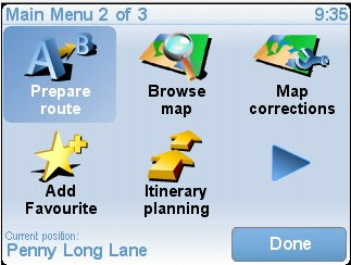
Touch the screen, select the second menu

menu2.jpg


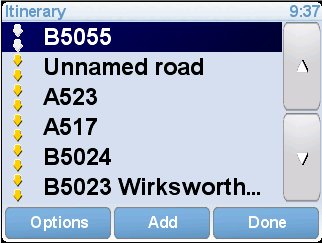
touch the "Itinerary Planning" icon, you will be presented with your itinerary.

Itin1.jpg


You will notice that waypoints that are passed will be greyed out, those unvisited below will be solid (ignore the inverse video of any line, that's an artifact of the computer program operating the Tomtom).

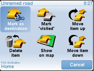
Touch the offending itinerary entry (probably the first non-greyed line, in my example the "Unnamed Road"). You will be offered the itinerary option menu

itinmenu.jpg


Touch the "Mark 'visited'" icon.

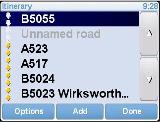
You will be back with the itinerary list with that line greyed out.

itin2.jpg


If this wasn't the first waypoint not visited, any previous one will also be marked as visited.

Touch the "Done" button, navigation will resume.

Should you decide to re-introduce a waypoint (maybe you got rid of the wrong one), repeat the procedure, the button that was "Mark 'visited'" will be now called "Mark 'to visited'", and will restore the waypoint to ungreyed (and any after it that were greyed).

Of course, you could always simply use the "Delete Item" button to remove a single entry.

Hope that helps.

 
Last edited by a moderator:
...Can anyone make any recommendations on how to map out a long trip along a very specific set of roads without constantly having to manipulate the GPS unit to delete a point that was missed? even when i attempted that function, the GPS would recalculate the trip and try to send me back to my starting point of the trip.

...
Firstly, when you specify a point on the map, zoom in to maximum magnification to make sure your selected point is on the road (and on the correct side if it's a wide road). I don't know what the distance is that Tomtom accepts as a "hit", but it's not all that great.

Secondly, if you do realise you've passed a waypoint without its being recognised, it's easy to tell Tomtom you've passed it, proceed as follows:

Stop the bike, the Tomtom Safety Police won't let you into the full menu structure unless you have.

Touch the screen, select the second menu

menu2.jpg


touch the "Itinerary Planning" icon, you will be presented with your itinerary.

Itin1.jpg


You will notice that waypoints that are passed will be greyed out, those unvisited below will be solid (ignore the inverse video of any line, that's an artifact of the computer program operating the Tomtom).

Touch the offending itinerary entry (probably the first non-greyed line, in my example the "Unnamed Road"). You will be offered the itinerary option menu

itinmenu.jpg


Touch the "Mark 'visited'" icon.

You will be back with the itinerary list with that line greyed out.

itin2.jpg


If this wasn't the first waypoint not visited, any previous one will also be marked as visited.

Touch the "Done" button, navigation will resume.

Should you decide to re-introduce a waypoint (maybe you got rid of the wrong one), repeat the procedure, the button that was "Mark 'visited'" will be now called "Mark 'to visited'", and will restore the waypoint to ungreyed (and any after it that were greyed).

Of course, you could always simply use the "Delete Item" button to remove a single entry.

Hope that helps.
Where in the heck were you 2 weeks ago when i was stuck in bumf&%$#@ ohio with my head stuck in my b*&^ not knowing where the hell i was or where the hell i was going? This is exactly what i needed. I actually got close to doing by using the delete item but for some reason i think the unit wouldnt let me delete my starting point, so it kept trying to send me back to the beginning. Can you try to delete your starting point and let me know what happens. I will definitly use this procedure next time i use the tom tom.

thanx again,

GreyGoose

 
Last edited by a moderator:
...Where in the heck were you 2 weeks ago when i was stuck in bumf&%$#@ ohio with my head stuck in my b*&^ not knowing where the hell i was or where the hell i was going? This is exactly what i needed. I actually got close to doing by using the delete item but for some reason i think the unit wouldnt let me delete my starting point, so it kept trying to send me back to the beginning. Can you try to delete your starting point and let me know what happens. I will definitly use this procedure next time i use the tom tom.

thanx again,

GreyGoose
You can delete any part of the route, touch "delete item", or mark the previous part as "visited", it will simply re-calculate from your current position to the first "un-visited" way point through to the destination.

As for where I was, not in front of you leading the way :rolleyes: , sorry.

 
Top