I originally posted this in the Northeast section. Just moving it over here in the ride reports section where it makes more sense.
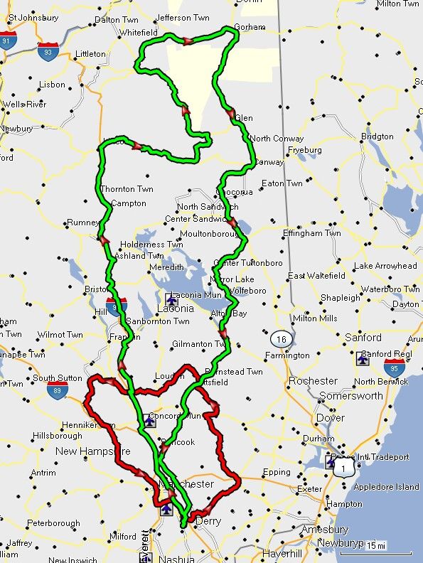
So, this morning, it was right around 9AM by the time I had committed myself, tried to connect with some locals (unsuccessfully), aired up the tires, and headed down the driveway. My plan was to make a grand loop around Mt Washington and the White Mountains in general. No time to dally...
Therefore, a little early AM slabbing was also in order, to get on up d'ere "toot sweet" (yeah, dat dere's French). I did divert onto the parallel side road of Rte 132 from Concord up to Ashland, but the roads were kind'a damp <_< and not freshly paved (understatement). <_<
In Ashland I opted back onto I-93 and slabbed on up the rest of the way to Lincoln for the start of the fun. :yahoo:
As soon as I turned off onto Rte 112 in Lincoln, I immediately realized that this was to be a different kind of day. There was NO traffic to speak of in the normally busy village of Lincoln. :huh: I buzzed right through and on up to the first scenic vista wayside, on the top side of the famous hairpin turn.

This ridge is called the "Three Sisters".

The next wayside up, just before the height of the Kank Pass, gives even more spectacular views to the southwest.


One of the most enjoyable parts of the it was that I had the place to myself. (Click picture below for full size panorama)

Here's a picture for all those Westerners to make fun of...

The view from wayside on the east side of the Kank pass was as beautiful as any time I've ever been there before. This is our traditional rest stop on the "Whites" ride.


And I also did not have to share this overlook with anyone...

There is a little alpine pond along the Kank. It sort of reminds me of the lakes in Glacier National Park, which I so long to visit that a picture of it hangs on our kitchen wall.

But, every picture looks better with a li'l Feejer, doncha know...

Sugar Hill overlook is on the way down the east side of the Pass. View is looking north.

And then on up through Bear Notch Road. It was repaved 2 years ago and is still in decent shape. I wasn't quite sure if it would still be open. They do not maintain it in winter and we did have a good dumping of the white stuff the prior week. But when I got to the gate it was open, and there were very few cars along the way. What fun!
View north from the first overlook on Bear Notch Rd

The village of Bartlett down below.

First good look at Mt Wash.

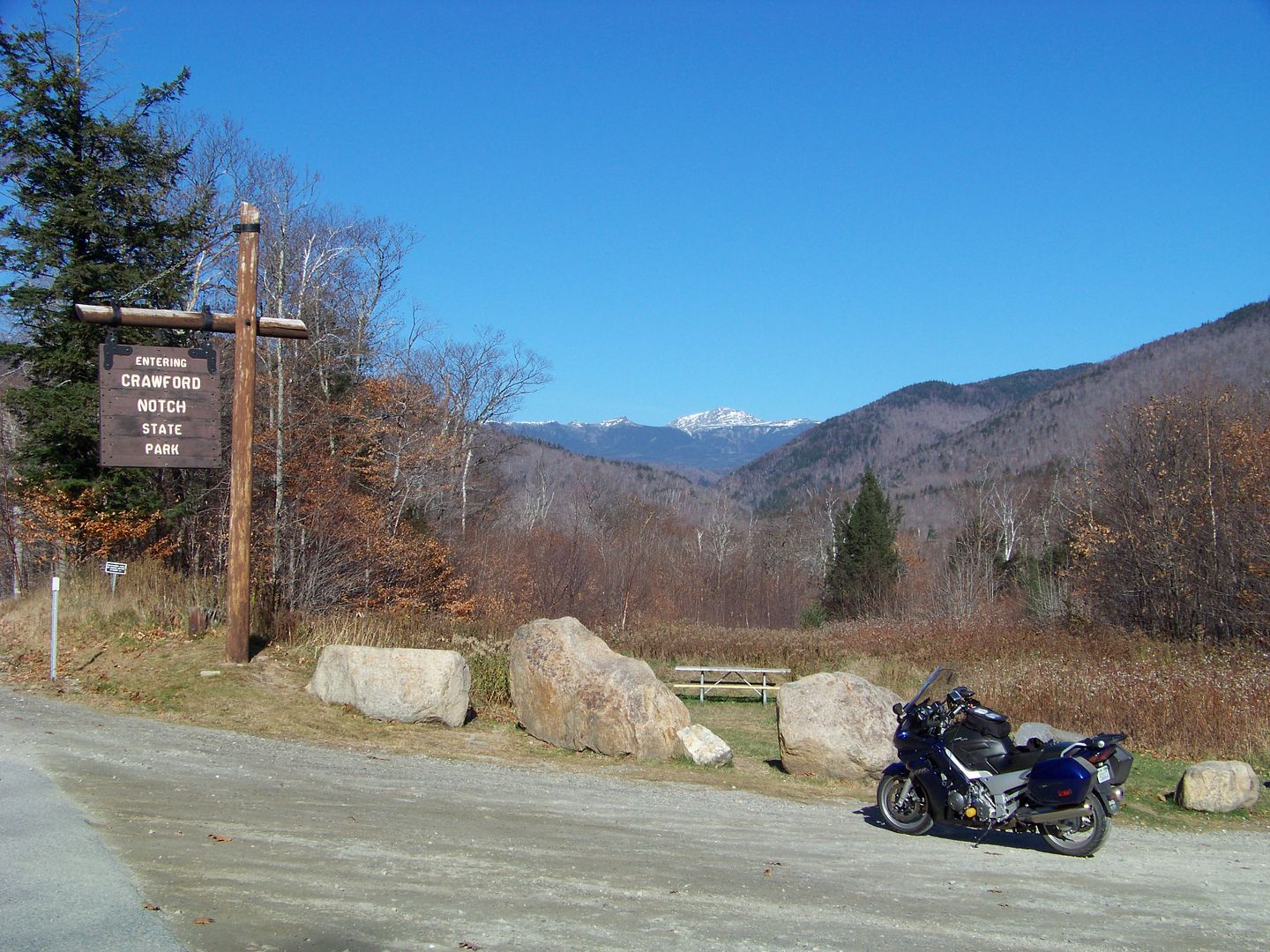
At the top of Bear Notch, I went left on Rte 302 up through Crawford Notch
Getting closer to George's Mountain

Here is the approach to the actual notch (left to right)

Up near the top of the Notch road, the Cascades were flowing nicely. This is Silver Cascade, the most impressive to me.

But the traffic was pretty unbearable

The old train station at Crawford Notch

This here is the "money shot" for the day. It is the eastern slope of Mt Washington, sprinkled with fall snow, and the Mount Washington Hotel and golf course in the foreground.

From there, I turned North again, from the town of Twin Mountain and up Rte 115 to Rte 2 in Jefferson. Across the north end of the Presidential Mountains to Gorham, then down Rte 16 through Pinkham Notch. Most people know of Pinkham Notch as the location of the start of the Mt. Washington Auto Road (closed today).


The infamous "Tuckerman Ravine".
All winter long snow blowing (and it blows very hard) over the top of Mt Washington, and it settles into the ravine. Because it is on the north east side of the big mountain it stays shady until the sun gets higher in the sky, so this is often the last spot on the mountain with deep snow in spring.
Annually in the spring, rugged outdoorsy folks climb up the steep face of the ravine and ski down it (there are no lifts).

That was my last notch of the day. From there I wandered down Rte 16 past the ever quaint village of Jackson. You have to go through this bridge to get to the village from the south side

Josie and I have spent a lot of winter days in Jackson. We like it more than the hustle and bustle of North Conway. Which is where I went next. There is a little wayside right in North Conway with a good view looking back up at the old man:

Well that was pretty much it. I ran down a few (new) favorite roads, Chickville Rd and from Ossipee to Tuftonboro, then Ledge Hill Rd and Rte 109A to Wolfboro. Then duked it out with the slow traffic down Rte 28 back to the homestead. All-in-all it was a pretty fabulous ride. Sorry that I couldn't share it with anyone else. But you know, sometimes, just you and your machine and the natural beauty... that can be the best day of all.
So, this morning, it was right around 9AM by the time I had committed myself, tried to connect with some locals (unsuccessfully), aired up the tires, and headed down the driveway. My plan was to make a grand loop around Mt Washington and the White Mountains in general. No time to dally...
Therefore, a little early AM slabbing was also in order, to get on up d'ere "toot sweet" (yeah, dat dere's French). I did divert onto the parallel side road of Rte 132 from Concord up to Ashland, but the roads were kind'a damp <_< and not freshly paved (understatement). <_<
In Ashland I opted back onto I-93 and slabbed on up the rest of the way to Lincoln for the start of the fun. :yahoo:
As soon as I turned off onto Rte 112 in Lincoln, I immediately realized that this was to be a different kind of day. There was NO traffic to speak of in the normally busy village of Lincoln. :huh: I buzzed right through and on up to the first scenic vista wayside, on the top side of the famous hairpin turn.
This ridge is called the "Three Sisters".
The next wayside up, just before the height of the Kank Pass, gives even more spectacular views to the southwest.
One of the most enjoyable parts of the it was that I had the place to myself. (Click picture below for full size panorama)

Here's a picture for all those Westerners to make fun of...
The view from wayside on the east side of the Kank pass was as beautiful as any time I've ever been there before. This is our traditional rest stop on the "Whites" ride.
And I also did not have to share this overlook with anyone...
There is a little alpine pond along the Kank. It sort of reminds me of the lakes in Glacier National Park, which I so long to visit that a picture of it hangs on our kitchen wall.
But, every picture looks better with a li'l Feejer, doncha know...
Sugar Hill overlook is on the way down the east side of the Pass. View is looking north.
And then on up through Bear Notch Road. It was repaved 2 years ago and is still in decent shape. I wasn't quite sure if it would still be open. They do not maintain it in winter and we did have a good dumping of the white stuff the prior week. But when I got to the gate it was open, and there were very few cars along the way. What fun!
View north from the first overlook on Bear Notch Rd
The village of Bartlett down below.
First good look at Mt Wash.
At the top of Bear Notch, I went left on Rte 302 up through Crawford Notch
Getting closer to George's Mountain
Here is the approach to the actual notch (left to right)
Up near the top of the Notch road, the Cascades were flowing nicely. This is Silver Cascade, the most impressive to me.
But the traffic was pretty unbearable
The old train station at Crawford Notch
This here is the "money shot" for the day. It is the eastern slope of Mt Washington, sprinkled with fall snow, and the Mount Washington Hotel and golf course in the foreground.
From there, I turned North again, from the town of Twin Mountain and up Rte 115 to Rte 2 in Jefferson. Across the north end of the Presidential Mountains to Gorham, then down Rte 16 through Pinkham Notch. Most people know of Pinkham Notch as the location of the start of the Mt. Washington Auto Road (closed today).
The infamous "Tuckerman Ravine".
All winter long snow blowing (and it blows very hard) over the top of Mt Washington, and it settles into the ravine. Because it is on the north east side of the big mountain it stays shady until the sun gets higher in the sky, so this is often the last spot on the mountain with deep snow in spring.
Annually in the spring, rugged outdoorsy folks climb up the steep face of the ravine and ski down it (there are no lifts).
That was my last notch of the day. From there I wandered down Rte 16 past the ever quaint village of Jackson. You have to go through this bridge to get to the village from the south side
Josie and I have spent a lot of winter days in Jackson. We like it more than the hustle and bustle of North Conway. Which is where I went next. There is a little wayside right in North Conway with a good view looking back up at the old man:
Well that was pretty much it. I ran down a few (new) favorite roads, Chickville Rd and from Ossipee to Tuftonboro, then Ledge Hill Rd and Rte 109A to Wolfboro. Then duked it out with the slow traffic down Rte 28 back to the homestead. All-in-all it was a pretty fabulous ride. Sorry that I couldn't share it with anyone else. But you know, sometimes, just you and your machine and the natural beauty... that can be the best day of all.
Last edited by a moderator: