More Garmin Stuff

Yamaha FJR Motorcycle Forum

Help Support Yamaha FJR Motorcycle Forum:

This site may earn a commission from merchant affiliate links, including eBay, Amazon, and others.
XM gave it to me free for 90 days once and it was almost worthless.
What model unit did you have?
I have a 550, and for the most part love it. I do use XM radio with it, but passed on the traffic and weather subscriptions.

I also have a Crackberry (8830) through Verizon that is my main phone and I can get weather on that, just not while riding. I also have an iPhone, and while it's pretty. ATT coverage is horrible. I carried both on our trip out west last year, and 2/3's of the time didn't have coverage on my iPhone.

-MD

Oh and here's the thing. The only place I have XM and use it is on the bike. I don't use it in the car, or home. I call them around winter time (for 3 months out of the year I don't get to ride) and threaten to cancel, they always negotiate a reduced rate for 3-6 months.

I'm currently paying $3/month for basic XM. I don't have any of the 'Best Of' and don't really need it.

YMMV

 
Last edited by a moderator:
I have the XM pod that came with my 2730. Is it the same one for the 478?
Wonder why the 478 is cheaper than the 378? By almost $200!
Same pod. Last August the 378 and 478 were the same price everywhere. I do not know why they are different unless the 478 is overstocked.

 
Those marine GPS units look interesting. Anybody mounted one of the 378/478 units between the bars at the stem nut? What mount product gives the best install for this specific GPS? Techmount or RAM ball or some other? The multitude of RAM adapters and such is a bit confusing, can't quite visualize the best way to fit one of these things to the bike. Always told myself paper maps are just fine,don't need no stinkin' GPS. :unsure: 
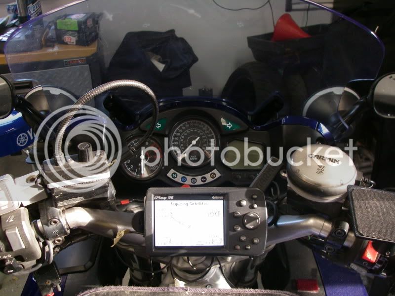
Think I'll be singing a new tune here shortly.... :)
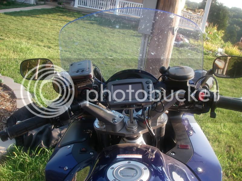
I have my 478 on a ram ball on a stem nut and am very happy. Whitehorsepress.com has all the ram parts you need except the stem nut. I use a short ram arm, the 478 ram bracket and an XM pod ram bracket. Amazon has the Garmin powercord but some just ust the pigtail included with the 478 (if you can figure out which wires are which). If you get a stem nut somewhere, you will find that the stem nuts are mounted by a 80 ft/lb gorilla.

 
I'm currently paying $3/month for basic XM. I don't have any of the 'Best Of' and don't really need it.
YMMV
How do you get it for $3 a month!! My first car was about $12 and each other radio was $8. Since they were offering a discount on the lifetime XM, I cancelled the two car radios and only run the Garmin XM radio now in whatever vehicle I want. I dare not say what I paid for a lifetime even though it is not Friday.
It's the retention game, and you have to get just the right *customer service rep*. Generally about every 6 months or so, more often around October/November, I get a bill, realize I won't be riding for 2-3 months, at least not in a fashion that I would use XM. Call them up say I want to drop it.

I explain to them it's used on a motorcycle and well, it's winter.

The transfer me to *retention* and we work out a deal. Usually half off for 3-6 months. My wife negotiated the current $3/month for 6 months. But like I said it's 'basic' there are a lot of channels I used to have but don't. NO baseball, no NASCAR, etc. But I"m OK with that.

One of the hail-mary's they threw one year to keep me as a subscriber was the XM traffic and weather, for free for a couple months. It wasn't even worth free to me.

FWIW, you can no longer say you're switching to Sirius :)

Like i said YMMV, but it never hurts to say "12 a month!!! are you kidding me? Can't you do better than that?"

:)

 
Here is the 2610 on stem mount

IMGP0132-1.jpg


Last edited by a moderator:
I have the 378 and love it. The diff between the 376 and 378 is in fact that the 378 has alll maps preloaded so it would make sence to get rid of the 376 that you have to load the area you are going to.
The diff between the 378 and 478 is the 378 has inland lakes and navicable rivers showing things like bouys on the large rivers. The 478 has the coastal waterways (saltwater).

Skooter Are you sure you can load maps into the 478 I would think it would be the same as the 378 as far as the software is concerened.
The mapping is different between the two models.

The one you want is the 478, To quote:

Because of the unique way the map data has been combined and loaded, the GPSMAP 378 is not compatible with Garmin's City Navigator NT North America DVD, which is sold separately. For example, if you use this City Navigator NT DVD to plan routes on your computer and transfer them to the 378, the unit will recalculate each transferred route.

The 478, which costs less does not suffer the limitation

Also note that while the 376 came (comes, if you can find an NOH version) with the XM pod, that's an extra cost item with both the 478 ans 478.
I had been considering an upgrade from the 376C to the 378 because I can only put about 1/3 of the US on a 512 MB data card. As a truck driver this means dragging out the laptop to change the maps on the card every other day or dealing with the basemap in the unit. The reason for the 378 over the 478 is that inland lakes would be far more useful information than coastal waterways for me.

So in essence you can still use City Navigator NT to transfer routes and custom POI's to the 378, it will just recalculate the route? Since I just plan my trips on the GPS and have never used the City Navigator NT software to plan a route, I assume this limitation would not bother me. On the other hand, if I can't get updated maps into the unit every 2-3 years that would probably upset me. Anyone know for sure if the 378 basemap (City Navigator NT) can or can not be updated when new maps become available?

David

p.s. I absolutely love the Nexrad available through XM MW (Not the NavWeather crap), but the $30/month for the fisherman package would be hard to justify if you didn't use it every day like I do.
I asked a friend if the 376 can be upgraded to a 378 with a firmware update... I'll let ya know. ;)

 
Just for my edification.

Can I take or use the XM Pod with XM music subscription that I have with my zumo and use it on the 478?

I saw the weather radar on Sully's GPS 2 EOM's ago and would love to have that functionality. I can always use a 2nd GPS too...

 
I asked a friend if the 376 can be upgraded to a 378 with a firmware update... I'll let ya know. ;)
Don't bother asking. The only way to upgrade a 376 to 378 would be to trade it in. Different configuration of the circuit board - the 376 has no map memory on board - even if Garmin supplied the same physical hardware, their firmware updates wouldn't allow you to flash the unit - you'd end up with a brick.

Just for my edification.
Can I take or use the XM Pod with XM music subscription that I have with my zumo and use it on the 478?
Same as answered in posts 14 & 21 above, yes.

 
Last edited by a moderator:
I had been considering an upgrade from the 376C to the 378 because I can only put about 1/3 of the US on a 512 MB data card. As a truck driver this means dragging out the laptop to change the maps on the card every other day or dealing with the basemap in the unit. The reason for the 378 over the 478 is that inland lakes would be far more useful information than coastal waterways for me.

So in essence you can still use City Navigator NT to transfer routes and custom POI's to the 378, it will just recalculate the route? Since I just plan my trips on the GPS and have never used the City Navigator NT software to plan a route, I assume this limitation would not bother me. On the other hand, if I can't get updated maps into the unit every 2-3 years that would probably upset me. Anyone know for sure if the 378 basemap (City Navigator NT) can or can not be updated when new maps become available?

David

p.s. I absolutely love the Nexrad available through XM MW (Not the NavWeather crap), but the $30/month for the fisherman package would be hard to justify if you didn't use it every day like I do.

This is exactlly why I went with the 378 because I also like to fish and it is good on the water on the bigger lakes.

I also do not plan my trips on the computer I usually look at paper maps and then just enter cities if I need gps guidance. Mainly use to see weather and find food and lodging.

The main problem would occur if you were to get in a group ride and everybody tried to download the route the 378 might change some of the roads but the destination would stay the same.

 
I had been considering an upgrade from the 376C to the 378 because I can only put about 1/3 of the US on a 512 MB data card. As a truck driver this means dragging out the laptop to change the maps on the card every other day or dealing with the basemap in the unit. The reason for the 378 over the 478 is that inland lakes would be far more useful information than coastal waterways for me.
So in essence you can still use City Navigator NT to transfer routes and custom POI's to the 378, it will just recalculate the route? Since I just plan my trips on the GPS and have never used the City Navigator NT software to plan a route, I assume this limitation would not bother me. On the other hand, if I can't get updated maps into the unit every 2-3 years that would probably upset me. Anyone know for sure if the 378 basemap (City Navigator NT) can or can not be updated when new maps become available?

David

p.s. I absolutely love the Nexrad available through XM MW (Not the NavWeather crap), but the $30/month for the fisherman package would be hard to justify if you didn't use it every day like I do.

This is exactlly why I went with the 378 because I also like to fish and it is good on the water on the bigger lakes.

I also do not plan my trips on the computer I usually look at paper maps and then just enter cities if I need gps guidance. Mainly use to see weather and find food and lodging.

The main problem would occur if you were to get in a group ride and everybody tried to download the route the 378 might change some of the roads but the destination would stay the same.
You can look at the x96 series Garmins. They are aviation/auto/marine and at the "high-end" (aka "pricey") of the Garmin portable line, although there is good supply and prices in the used/refurb market. I have the 496 that I use between a helicopter, car, FJR, and boat. The cheapest XM package for the aviation series is "Aviator Lite". I provides detailed weather forecasts and near realtime moving weather radar map overlays. Dodging the thunder-boomers in the helicopter is even more important than on the Feej. It's first rate, and you pay for it (about $35/month).

 
You can look at the x96 series Garmins. They are aviation/auto/marine and at the "high-end" (aka "pricey") of the Garmin portable line, although there is good supply and prices in the used/refurb market. I have the 496 that I use between a helicopter, car, FJR, and boat. The cheapest XM package for the aviation series is "Aviator Lite". It provides detailed weather forecasts and near realtime moving weather radar map overlays. Dodging the thunder-boomers in the helicopter is even more important than on the Feej. It's first rate, and you pay for it (about $35/month).
I looked at the 496 when I bought the 376C, but just couldn't justify the $2400 price tag since I haven't flown in several years. It would probably be the best choice for me, but Garmin is really proud of those aviation products. It looks like the 378 is similar to a 496 minus the aviation specific programming and mapping, and a bit slower refresh rate.

I'm just tired of the constant need to upload maps to the 512MB map card in the unit on the 376C, if they had thought ahead and made 2GB cards available for these units I wouldn't even be looking to upgrade. :angry:

I guess I need to buy a lottery ticket, since I've heard you can't win if you don't play. Then I could get a lot of cool stuff and not care what it costs.

David

 
Top