Need advice - last 3 states CA OR WA

Yamaha FJR Motorcycle Forum

Help Support Yamaha FJR Motorcycle Forum:

This site may earn a commission from merchant affiliate links, including eBay, Amazon, and others.
The southern Oregon coast is a beautiful area of the country, one of my favorites. Be sure to check out the Oregon Sand Dunes Recreation Area (open OHV area on the coastal dunes), the Newport Aquarium (its where Keiko the whale was rehabilitated before being released back to the ocean) , Depot Bay (smallest harbor anywhere, great place to take a whale watching or coastal excursion from), the Tillamook cheese factory (great ice cream!), and if you're into aviation, the Tillamook Air museum and Evergreen Aviation museum in McMinville are absolute must see's. Tillamook is mostly WWII aircraft, and McMinville is the home of Howard Hughes' Spruce Goose, and is in a much better display than when Disney owned it down in Long Beach.

 
Leaving in 2 (or 3) days! I was planning on keaving on Friday but my daughter just bought a condo & the closing is Fri AM :(

May still get to bug out of work by 2 PM & cover 3-400 miles . . .

Change in route - our friend moved back to Connecticut so no Arizona. Looks like I am going to follow 80 to just north of San Fransico & pick up Rt 1. That's the starting point of the real ride & I expect to get there next Wednesday.

I expect you all to provide proper hospitality, ie excellent weather :)

See Ya!

 
...expect to get there next Wednesday.
I expect you all to provide proper hospitality, ie excellent weather :)

See Ya!
Let us know when you're in the area.

Hospitality...hell yes! Weather, take your pick either sunny and 70 (this morning) or rain and 50 (now). One never knows from day to day.

--G

 
Just saw your thread today - guess you're about leaving, but are checking in!

and you're bringing mucho photo gear = scenery you want, right?

Looks like I am going to follow 80 to just north of San Fransico & pick up Rt 1. That's the starting point of the real ride & I expect to get there next Wednesday.
well, 3 thoughts:

1) general weather, unless it's mid-July to mid-Sept the coastal areas are probably going to be cool (50s, maybe 60), more or less damp.

about 100 miles inland is the Cascades Range of mtns and east of them it's a drier, warmer and sunnier climate.

If your map doesn't show mtn ranges, well: Sacramento, CA; Bend, OR; Yakima, WA are all on the warm side of this 'climate divide.'

2) Utah - Nevada - CA route. Interstate-80? NO, use Rte 50.

When you get to Utah or Wyoming you're going to have had your fill of interstates and the limited photographic opportunities.

The next east-west crossing south of I-80 is US Rte 50 running from Delta, UT to Sacramento, CA. It is much better.

#50 takes you up and over all the folded mtn ranges of NV that buckled when continental shelf rammed into pacific shelf (actually kinda fun to zoom up and down all those mtn passes in succession and the straights in between),

see Indian petrogliphs, basically take a modern two lane fast road thru the old west; in Nevada this is nicknamed "The Loneliest Road in America."

Rumored that sometimes engines emerge from this stretch totally carbon-free ... then #50 goes past Lake Tahoe (scenery) into CA.

If your schedule calls for overnighting in NV, well Eureka is an old gold mining town (never stayed there, looked cool); Ely in eastern NV is an old mining town

and its 'downtown' Hotel Nevada was once the tallest building in NV. Stayed there, kinda funky fun in a NV sense. Both towns would be very different from east coast.

And rte # 50 photography will be more available than I-80 (excepting for Bonneville Salt Flats).

3) dog-leg to scenery in southern UT. With your interstate buzzing out to the west I'd time-out and go south to Escalantee and Zion Nat'l Park, UT,

maybe leaving the interstate south at Rock Springs, Wyoming. After seeing / photographing them get back to Rte 50, probably at Ely, NV. See your AAA map.

If you haven't been to Zion Park, and are a photographer, you will love it!!

Rooms will be expensive here, kinda like city prices - I'd try the Quality Inn, Springdale, UT.

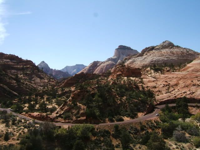
ZION Park - and there are much better shots ...

May142010111.jpg


But, notice the blacktop road ... is red in color!

at Escalantee / rte #12, well I don't have photos of coming into town from the north (suggested rte) over rte #12, but it is dramatic and photogenic and curvy. just wow.

Need to overnight there? - Small town, try the red roofed motel or the Outfitters Store, which has cabins and makes good pizza; has only beer in town, try their Polygamy Porter on tap.

Dinner at Outfitters, b'fast at motel restaurant is how I do it.

travel wise, bet you won't need reservations anywhere except Nat'l Park areas maybe. Enjoy.

EDIT: looking forward to your posts...

 
Last edited by a moderator:
Thanks UHOH for all the great info. If this is Monday, I must be in Cheyenne, WY. . .

That's both good & bad :(

I set out to average 600 miles per day and I'm right on target - 1800 in 3 days. That's the good part.

Today's ride from Councul Bluff, IA was the ride from hell - most of the 525 miles. It started off fine. I was on the road at 6:30 & the temps were already in the mid 70's. Within a short time the crosswinds started, like what I had the day before in Iowa.

Today they were stronger. With a 75 mph speed limit I had a tough time doing it without leaning a lot - it was a lot of work. Then I saw what I thought was the cloud from hell. Off in the horizon was this large, nasty, ulgy looking, black cloud and I was heading for it. I decided it was a good time for breakfast & scooted off the next exit. Actually by the time I got back on 80 most of it was to the north, but not quite all. The temps dropped from 76 to 61 in a blink & then the pelting rain started, matched only by the friggin lightning. Fortunately I was really on the edge and it was over in 15 minutes. The temps popped back to the mid 70's, only the strong cross winds made it tough. It really was pretty hard riding. When I reached the Wyoming border and the foothills started I thought I was home free.

Shortly into WY I saw a really weird cloud ahead. At first I thought it was smoke. A sport tourer heading eastbound signaled me to turn around. I knew it wasn't good. Then the temps went fron 76 to 43 and the winds picked up to god knows what - I would guess at least 60-70 mph, maybe more. For the 1st time in my life I could not control my bike - at any speed. There I was on rt 80 going 15 mph and I couldn't keep in in the breakdown lane. The winds had shifted direcgtion 180 degress now coming out of the north. I managed to make it 1/2 mile to an exit and took cover under the bridge with 2 pickups. There was nowhere else to go except 2 dirt roads that didn't look so inviting. After 1/2 hour it had calmed down some & I hopped back on 80 - with the crosswinds from hell.

I had to get off about 8 miles from Cheyenne - it was just too dangerous going 45. At the truck stop I learned of a backroad that took me into Cheyenne. My original target was Laramie, not very far past Cheyenne. I have been told they have had some considerable snow there - not only there but pretty much all of 80 is a mess in the mountains. . . now what??

I have to check the weather tonight. I don't know what options I have. Somehow I have to get across the mountains :(

I can't see waiting here for days for the weather to break!

 
Some of the oddest weather in my 40+ years in Sacramento this spring, for sure. It's been way below average temperature, and the rain is staying much later than usual. The plus is it's usually brown everywhere by now; this year it's green and much prettier. We have a good chance of rain tomorrow, and showers still possible Weds. Other years it's been hot as hell on this date and hasn't rained for six weeks. Myself, it's much better this way. If you're on 80, it will be cold from Reno over the summit, but a couple of hours should do it. You can get conditions from Caltrans, 1-800-427-7623. It's automated and updated as needed; you just punch in the highway number. Snow on the roads is possible, but unlikely.

Assuming you have the Assistance List handy? Give a call when you'll be down my way. Some of us retired guys just sit around waiting for a reason to ride. We can get a little riding in, get some lunch, whatever you need. Be safe.

Sac Mike

 
If today is Tuesday, this must be Elko, Nevada!

As bad as riding conditions were yesterday they were quickly forgotten when I got on the road this morning in Cheyenne :)

Although it was cold - 39 when I hit the road and down to 32 in Laramie - I was dressed for it and didn't mind the 1st couple of hours. By then the thermometer was reading in the balmy low 40's and all was well. With all my extended stops (I now make it a point to get off in small towns and find the local eateries for breakfast & lunch) I still managed to roll up almost 700 miles today.

With any luck I should be on the California coast tomorrow evening :)

 
Last edited by a moderator:
After you do the spiral highway near Lewiston, turn around and come back down and ride highway 12 east to missoula. You will be riding alongside the clearwater and Lochsa rivers, with enough curves and passing room to keep a grin on your face for a long time.

 
Crap, Aasland, I was thinking about riding up that way, but now you've posted all the pictures and spoiled it for me. It's like I've already been there now. :angry:
Oh, I didn't post ALL my photos, or ALL the places ;-) Those are just the highlights ... I didn't detail the twisty roads, like 224, NF19, 53, etc.

We lived in Oregon only four years, but didn't come close to exhausting where was to see.

To everybody thinking of coming to Oregon: Those photos were photoshop'd. It rains constantly here. You wouldn't like it. Just travel up I-5 to get to the good places: like California and Washington! ;)

 
Crap, Aasland, I was thinking about riding up that way, but now you've posted all the pictures and spoiled it for me. It's like I've already been there now. :angry:
Oh, I didn't post ALL my photos, or ALL the places ;-) Those are just the highlights ... I didn't detail the twisty roads, like 224, NF19, 53, etc.

We lived in Oregon only four years, but didn't come close to exhausting where was to see.

To everybody thinking of coming to Oregon: Those photos were photoshop'd. It rains constantly here. You wouldn't like it. Just travel up I-5 to get to the good places: like California and Washington! ;)
That's about right, too!

 
If today is Wednesday, this must be Petaluma, CA!

1 down 2 to go :)

The ride today from Elko, NV was pretty good EXCEPT Donner Pass. When I reached the summit it was snowing and sleeting but the temps were fairly warm. As I descended I watched the thermometer on the bike keep dropping one degree at a time from 42 to 32. It was rapidly becoming a tension convention to ride. I slowed down to 35-40 and had my flashers one. Cars & trucks weren't moving much faster. By the time the temps hit 32 I was commited to going all the way down.

First the windscreen completely iced over. No biggie I look over it anyway. When my face shield iced over it became a little more serious. I cracked it open so I could look under it & over the top of the screen. That worked ok except for the sleet that was pounding my lower face. When my glasses got wet it was time to bail.

I found the next exit & took shelter under the bridge. In 15 minutes the crap stopped falling from the sky and I hopped back on 80 & finished the descent.

Now I sit, poised to start at Point Reyes tomorrow AM & head north along the coast. Tomorrow is the day I start taking some pix & really enjoying the ride!

 
Good to meet you this morning Jerry. Hope our directions weren't too bad and you managed to find a good road or two and not too much rain. Ride safe and keep us updated!

--G

 
Top