Route Planning & Goat Path Avoidance - Google and Bing Maps

Yamaha FJR Motorcycle Forum

Help Support Yamaha FJR Motorcycle Forum:

This site may earn a commission from merchant affiliate links, including eBay, Amazon, and others.

leedavis

Well-known member
Joined
May 20, 2007
Messages
462
Reaction score
44
Location
Lenoir, NC
Like many here I often use Google Maps to rough out routes which I then convert for use with GPS. A problem with roads out in the sticks is that Google Maps satellite view is often too fuzzy to determine what an unknown road is like. About a year ago I checked out Bing Maps and have since found that in almost every case the Bing satellite view is much clearer. Google Maps is still my favorite for basic route planning but Bing Maps gives a better reference for seeing if a road is doable.

Here's an example where Holloway Mountain Rd crosses the Blue Ridge Parkway showing a typical difference in resolution.

Google Version

Bing Version (north on Holloway Mt Rd looks kinda iffy)

 
Google Maps is still my favorite for basic route planning
Lee, you should invest into a copy of MS Streets and Trips. It incorporates Bing, letting you switch between views, and is a far better method of route planning, also allowing export to GPX files read by Garmin and others. A copy will set you back less than $20 if you keep an eye out online.

I usually start planning in Streets and trips, toggle the Bing view to verify, then export to GPX. Because every GPS will try to conform the route to its map, I usually open up in Garmin Basecamp and recalculate the route to verify it conforms to my intended path, then I save as a Garmin file, and transfer to the GPS. If the route does not conform, I'll go back and add some waypoints in S&T along the route to force Garmin to follow my route. So much easier than using Basecamp or Google.

I've still had my share of "Garmin Moments" but this helps to reduce.

 
Last edited by a moderator:
Thanks for posting Lee...and Hudson.
punk.gif


I'm always looking for a better way...and petey knows I hate gravel...so this looks like a good tool. :D

 
In Google Maps you can also drag the little man from the zoom tool & look @ the road @ street level. This only works some of the time, though. Don't ask how I know.

 
In Google Maps you can also drag the little man from the zoom tool & look @ the road @ street level. This only works some of the time, though. Don't ask how I know.
The little guy doesn't like to show up on some of the secondary roads...cuz he's too busy cruzing the Interstate and city streets. :D

 
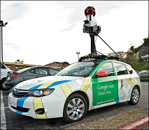
Little google guy only shows up on roads they drove the google van down. Not too many dirt roads get google van-age.

Trying to plan a route that intentionally goes down dirt and gravel roads is even trickier than trying to avoid them.

I've also noticed that the satellite image resolution varies greatly. If Bing is always better they must have a line on a source of better images than G. A Lot of G's images are 6 or more years old too. It's often a blast to the past and the site now longer looks like it did back then.

Thanks for the tip. I shall incorporate that in my route planning bag of tricks.

 
I've also noticed that the satellite image resolution varies greatly. If Bing is always better they must have a line on a source of better images than G. A Lot of G's images are 6 or more years old too. It's often a blast to the past and the site now longer looks like it did back then.
Google offers "Google Earth Pro" but it's a $399/yr subscription. That's way out of my league though apparently they have broader coverage with high resolution satellite imagery, just not for free.

 
Last edited by a moderator:
In Google Maps you can also drag the little man from the zoom tool & look @ the road @ street level. This only works some of the time, though. Don't ask how I know.
The little guy doesn't like to show up on some of the secondary roads...cuz he's too busy cruzing the Interstate and city streets.
biggrin.png
Purdy sure that I said it works only some of the time. Usually, if it doesn't show with Google man, I won't plan the road. I've done the opposite & ended up on dirt, too.

 
In Google Maps you can also drag the little man from the zoom tool & look @ the road @ street level. This only works some of the time, though. Don't ask how I know.
The little guy doesn't like to show up on some of the secondary roads...cuz he's too busy cruzing the Interstate and city streets.
biggrin.png
Drag the little Google dude onto the map, every road that has street level imagery will turn blue. No blue, no street level coverage no matter how much you drag his *** around the map :)

 
Things have greatly improved since the days of MapQuest's recommendation of taking the 100 mile direct route betweeen Winnemucca and Gerlach, NV. It seems reasonable that it would be better than the 300 mile trip via interstate highways but don't bet your bike or finish time on it.

 
Things have greatly improved since the days of MapQuest's recommendation of taking the 100 mile direct route betweeen Winnemucca and Gerlach, NV. It seems reasonable that it would be better than the 300 mile trip via interstate highways but don't bet your bike or finish time on it.
You need to be careful with Google Maps recommendations as well. It's only recently it will not attempt to route you down a logging road between Sudbury and Wawa called the Sultan Road. Believe me, you will NEVER BE FOUND had you taken that route.

 
Little google guy only shows up on roads they drove the google van down. Not too many dirt roads get google van-age.
OMG, extremely RARE chance to correct fred w.

google car:
Go easy on Fred with this one, the Google VAN shot his dog while he was barking at the vehicle. You can clearly see his bestest dog down by the street giving the van a good telling-off while his other dog in the background was sniffing the dandelions and ignoring the whole thing.

 
Go easy on Fred with this one, the Google VAN shot his dog while he was barking at the vehicle. You can clearly see his bestest dog down by the street giving the van a good telling-off while his other dog in the background was sniffing the dandelions and ignoring the whole thing.

It's all true!!

GoogleStreetView.jpg


Not only did the Google Van shoot my dogs, but they caught Josie from behind walking up the driveway too!

 
Little google guy only shows up on roads they drove the google van down. Not too many dirt roads get google van-age.
OMG, extremely RARE chance to correct fred w.

google car:
Go easy on Fred with this one, the Google VAN shot his dog while he was barking at the vehicle. You can clearly see his bestest dog down by the street giving the van a good telling-off while his other dog in the background was sniffing the dandelions and ignoring the whole thing.
Isn't the bestest dog the one in the driveway ? ;)

 
Isn't the bestest dog the one in the driveway ?
wink.png
Depends if you are making a distinction between favorite or best behaved. I think Fred prefers his special needs ADHD doggie. It's just everyone else that gets a crotch sniff that leaves bruises, has their personal possessions stolen and has their work gloves carried off that may have a different opinion :lol:

 
Top