GPS File type you get in a Rally Thumbdrive

Yamaha FJR Motorcycle Forum

Help Support Yamaha FJR Motorcycle Forum:

This site may earn a commission from merchant affiliate links, including eBay, Amazon, and others.

Willie

Well-known member
Joined
Sep 9, 2009
Messages
536
Reaction score
7
Location
N Uxbridge MA
When you guys get the thumbdrive with the Bonii in electronic format what format is it in. For Garmin would you get a GDB file for use in MapSource or would you get a generix GPX file that had a bunch of waypoints or just get a CSV file that you had to import to your mapping programs format using something like GSBabel.

This is more from a curiousity standpoint, and trying to gain an understanding of the StreetPilot world, which I think you had to use MapSource to get data into the unit, versus the Nuvi/Zumo world where GPX files work along with sending data from MapSource to the unit. Hnnce the Nuvi/Zumo world is giving a user many more choices to use for routing software.

Willie

 
At the Team Strange rallies they have come out with all three formats GDB, GPX and a text file.
Same for the IBR. Some previous year's data files are downloadable here.

the Nuvi/Zumo world is giving a user many more choices to use for routing software.
Any mapping package can be used to create waypoints/routes, as long as the output can be converted (typically by a 3rd party program) to GDB format for uploading to MS then sent to the SP. So just extra steps needed for the SP's, but it's a tradeoff I gladly make for the (IMO) superior routing capability of the SP series.

 
Last edited by a moderator:
Depends on the rally. If it were me I'd be prepared to deal with only a GPX file, since that's the "standard" for interchanging files. As long as you can convert GPX to whatever your favorite map software is, you'll be fine. In practice I think everyone hands out GDB files also.

 
As long as you can convert GPX to whatever your favorite map software is, you'll be fine. In practice I think everyone hands out GDB files also.
I agree.....a .gpx file is probably the most ubiquitious and one I'd be sure I could handle. It's also nice because you can edit it in a text editor before importing it to mapping software.

The Good, The Bad, The Ugly handed out four files if IIRC. A .gpx, .gdb, .txt, and a .kml file.

 
you can edit it in a text editor before importing it to mapping software.
Now you have me curious, what do you edit before you use in mapping software ???

Willie
Most of the time I strip out the waypoints, so they aren't accidentally loaded as Favorites in a Garmin device. I may also remove track logs to further reduce the file size. That permits me to store a boatload of GPX route files on my SD card (leaves more space for music).

Most of my GPX route files are less than 512k (1/2 Megabyte).
NA for a rally. They don't give you routes, they give you waypoints.

 
Now you have me curious, what do you edit before you use in mapping software ???
I edit bonus names to add information from the packet so they're more useable in mapping software and the GPS while riding. It's standard stuff from the Jim Owen Routing 101 seminar he and/or other riders give at the IB National events. (that's a hint if you're interested in the competitive rally stuff....next year somewhere)

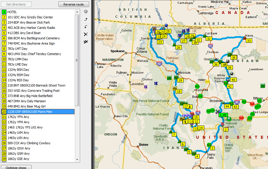
An example from the GBU bonus packet was a bonus simply called "DSP" in the file. But, I changed the name to "1226 DSP 0800t2100 Piano Man" before I brought it in my mapping software. That added information includes how many points the bonus is worth (1226), that it's only available between 8 a.m. and 9 p.m., and I'm looking for "Piano Man" as I get close to it. I think it's downright dangerous and risky to be reading through the packet while I'm riding (including risk of your packet flying out on the freeway) and taking 30 minutes or so to add that information pays dividends while on the rally.

There are a variety of other shorthand notations I use, but you get the gist.

Here's a peek into the winning route for that rally and how it would have looked in Streets and Trips to me as I drifted off to sleep 6 hours before:

GBUSnapshot.jpg


Now you have me curious, what do you edit before you use in mapping software ???
I edit bonus names to add information from the packet so they're more useable in mapping software and the GPS while riding. It's standard stuff from the Jim Owen Routing 101 seminar he and/or other riders give at the IB National events. (that's a hint if you're interested in the competitive rally stuff....next year somewhere)

An example from the GBU bonus packet was a bonus simply called "DSP" in the file. But, I changed the name to "1226 DSP 0800t2100 Piano Man" before I brought it in my mapping software.
OK I thought you were adding something to the WP, not easily added once it was in the mapping software. I could see that it would be easier in the GPX file in a text editor if you were adding the same thing to each waypoint where you could just do a copy and paste to each waypoint versus editing each one in say MapSource.

 
Top