Update on Cali State Route 1 Closure

Yamaha FJR Motorcycle Forum

Help Support Yamaha FJR Motorcycle Forum:

This site may earn a commission from merchant affiliate links, including eBay, Amazon, and others.

SacramentoMike

Not Safe For Work
Joined
Nov 5, 2007
Messages
5,065
Reaction score
1,834
Location
Sacramento, CA (honest)
.

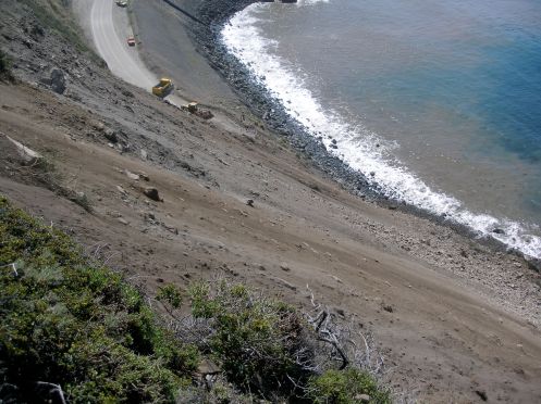
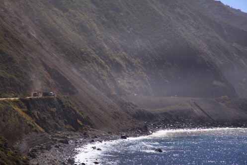
It's been over a month since that big ugly slide. See how ugly it was?

hwy1-2.mi_standalone.prod_affiliate.76.jpg


I haven't been seeing anything about the status of the road lately, so I started digging around. All I could really find on line was that it was still closed. So I called the CHP office in San Luis Obispo and asked. According to them, that thing's toast pretty much all summer long. :( Or worse.

I know I posted at the time that I was sure it would be open in a month or so, but once I saw this pic I understood better what they were really facing. Anyway, you probably should be re-thinking any planned rides past this spot this summer (San Luis Obispo-Monterey County line, 12 miles south of Carmel). If anybody has tried riding the detour (Nacimiento-Fergusson Rd.), I'd be curious about how it went. Traffic? Delays?

 
Thanks for the update. This closure is unwelcome but, as you know, this seems to happen every few years. I remember first dealing with it in 1969 or early 1970! A friend and I drove from Berkeley to roughly 20 miles north of Kirk Creek and then had to turn around when we could not find anyone northbound on the other side of the slide (we hiked over it) who wanted to trade their car for my '64 Falcon station wagon.

 
Actally that picture indicates that the road should be open to motorcycles only. ;)

Thanks for the heads up...

 
Last edited by a moderator:
They've established one way traffic through that area via lights. There is an additional closure south of Gorda that is also creating trouble for us southern locals that like to make lunch runs up to Big Sur. If you enter from Monterey, you can now get through to Big Sur, but you can't get to Morro Bay. The only way to get to Morro Bay, San Luis Obispo, etc. is to take Nacimiento Fergusson Road inland to Paso Robles. This is supposed to last thru May if not longer from what I've heard.

Nacimiento Fergusson Road is Open and is in good shape. If you're travelling inland to the coast, you need to have your registration, insurance and license handy to enter Fort Hunter Ligget. No big deal, you just need to have it handy so you don't hold up the show.

If you're travelling from the Coast inland, you don't need to worry about it. As its the only way for southern folks to get to the coast, the traffic is heavier than usual so you just have to take it slow and cautious as meeting traffic on some of the tight corners can be encountered.

 
That is one ugly picture! Glad one lane is open at least. But with summer traffic at peak times what it is, that might be wise to avoid if possible? PBS did a special on the making of Route 101/1 and mentioned the constant struggle with slides and washouts -- one reason they never went through the Lost Coast in northern California with Route 1, was they couldn't figure out a stable enough (geologically speaking) route and went inland.

 
Nacimiento Fergusson Road is Open and is in good shape. If you're travelling inland to the coast, you need to have your registration, insurance and license handy to enter Fort Hunter Ligget. No big deal, you just need to have it handy so you don't hold up the show.

Don't neglect to have it but the credentials are no longer necessary to traverse the base to get to N-F Road and Hwy 1, vice-versa. If you mismanage your fuel and need to fill up at FHL, that would require you to head to the cantonment of FHL and only there will you be required to show credentials. I've never used it but my understanding is the fuel depot there is a self-serve, automated, credit card only apparatus.

CalTrans is dealing with NOAA and probably a myriad of other agencies due to the proximity of the National Marine Sanctuary as well as waiting on 3 special Spider Excavators to tackle the top of the Alder Creek Landslide which is 2 miles south of the tiny town of Gorda where fuel, if even available now, is probably $6 plus! Gorda always seems to get the most expensive fuel in the nation designation! As of last Friday, the CalTrans estimate was 4 to 6 weeks remaining on the Alder Creek slide closure.

As mentioned, the Rocky Creek slide which was just north of the Bixby Bridge, closer to Carmel, is open 24/7 in both directions now with no weight restriction. It is a one lane, red light controlled passage now which is customary with most of the Hwy 1 repair projects. My personal experience regarding delays with traffic control is usually if you just miss the green light, expect about 10 minute delay. It's also a great time to filter to the front of the line! ;)

Here's a shot of the north side of the Alder creek slide from about a week ago. You can see by the scale of the large front-end loader and conventional Peterbilt 10 yard box transfer loader, there's just a little bit of dirt on the road!

p1010431.jpg


img_0340.jpg


Last edited by a moderator:
So if one was to go north from Paso Robles on the inland canyon roads towards Monterey...then south on HWY 1, what would that look like with the detours?

 
This is the scenic/twisty route I have recommended to travelers going north or south.

https://maps.google.com/maps?f=d&source=s_d&saddr=CA-1+N&daddr=CA-46+E%2FGreen+Valley+Rd+to:Vineyard+Dr+to:Chimney+Rock+Rd+to:Nacimiento+Lake+Dr+to:Co+Rd+G14%2FInterlake+Rd+to:Co+Rd+G14%2FJolon+Rd+to:Nacimiento-Fergusson+Rd&geocode=FQzGGwIdIO_L-A%3BFRSAHgIdClPN-A%3BFXjKHwIdgubL-A%3BFVyVIAIdzsbM-A%3BFbThIQId_FjL-A%3BFQJaJAId5G7I-A%3BFeXXJAIdW__G-A%3BFZgdJQIdmjLC-A&hl=en&mra=mi&mrsp=7&sz=11&sll=36.006895,-121.528015&sspn=0.364381,0.727158&ie=UTF8&ll=35.69411,-121.063843&spn=0.731641,1.454315&t=h&z=10

To answer your question specifically, heading north from Paso would get you to Nacimiento-Ferguson Rd and through the Army Base. Once you catch Hwy 1 and head SOUTH as you state, you would hit Gorda in about 5 miles or so and the Alder Ck slide closure is below there 2 miles or somewhere in between.

 
Those bottom two pictures are incredible. I am planning a trip up from the South. If I could make it a little past Nepenthe and turn around, I could live with it. That should be fine right?

Update: Just called them, I am now clear...not an option.

 
Last edited by a moderator:
You can make it all the way to Carmel way past Nepenthe. To be clear, you will need to bypass the lower Alder Creek slide by taking Nacimiento-Ferguson Rd to get to Hwy 1. Once you do that, you're good to go north to Nepenthe and beyond with just the short delay at the one way traffic control north of the Bixby Bridge.

As previously mentioned, just be cautious on N-F Road, especially the coastal side because it is steep with very tight turns and it will have more traffic than usual since it's the ONLY southern outlet/inlet to Hwy 1. Lord only knows what type of traffic you might encounter and I'd guess the corners will be pretty dirty since so many cars will have traversed it and run off the corners.

 
Last edited by a moderator:
I just heard from a guy who took his family over Nacimiento, pulling a camper with his truck!

He said the first third was fine, the next third got interesting and then he rode the brakes down to the coast! After pulling over for a moment, to let a buddy catch up, he realized he had no brakes left at all!

Lucky for him a good samaritan hooked him up with new brake fluid and helped him bleed the brakes to get him back on his way!

Just thought I'd relay the story for any who might not be familiar with "the back way into to places"!


Latest posts

Top