Groo
The Endless Font of Useless Knowledge...
Is the term "centerstand racing" entering our lexicon now? :huh:

Hey TC,Here's a question: can I average 65mph (slightly above the required BBG average speed) over this section of US50 in Nevada and SR-21 in Utah, during daylight hours on a Sunday in late September/early October? Would a weekday be better? Thanks.

Cool I'll try that when I get home.Rogue,
"Cntrl"-"Print Screen" buttons hit at the same time will capture whatever is on your screen. Then open something like IrfanView, or any other image manipulation software and paste it in. Save it as a .jpg and there you go. Least, that's what I do... there may be another way.
Within S&T there's also an option under File of Save to Web Page. This publishes it to a directory of your choice on your computer that then could be copied to a web server and utilized including directions and other options. Only thing I don't like about this option is that it saves the map itself in a .gif format and tends to be much bigger than converting it to a .jpg.Hey TC,How do you post the map with your route?
I'm planning on trying a BBG with an in state (NV) SS1000 on the way to Reno and would like to post the route, I've got it on Navtec (Garmin). I can print it to PDF. but haw do you print it to a jpeg?
Did nothing at all on my computer"Cntrl"-"Print Screen" buttons hit at the same time will capture whatever is on your screen. T
Then open something like IrfanView, or any other image manipulation software and paste it in. Save it as a .jpg and there you go.
Don't have S&T or a web server! :huh: And I don't want to buy them to show one copy of a map. :blink: :blink:Within S&T there's also an option under File of Save to Web Page. This publishes it to a directory of your choice on your computer that then could be copied to a web server and utilized including directions and other options. Only thing I don't like about this option is that it saves the map itself in a .gif format and tends to be much bigger than converting it to a .jpg.


:lol: What Iggy said Rogue... got a good chuckle out of "it didn't do anything"... you expected maybe a bolt of lightning or something ?Back to the "Ctrl" + "Print Scrn" thing then for you.
It doesn't do anything outwardly visible. It just copies the graphics of the active window to your clipboard.
If you then go to a program that you can paste from your clipboard.....like Paintbrush. Everybody who runs windows has that. In Windows XP it's Start, Programs, Accessories, Paint. Then "Ctrl" + "V" to paste it. You can save the picture after you crop it or manipulate it.

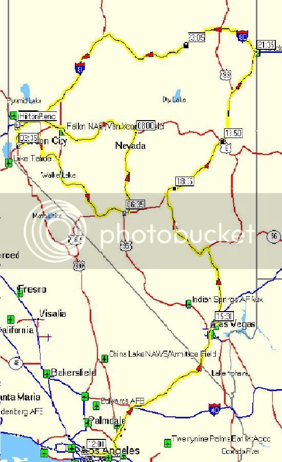
Manly endeavor! Best to ya'! See ya in Reno.My plan is to leave Pasadena between 12:00 and 13:00 hours Wednesday, hit Vegas around 15:30, up to Wendover and over to Reno at 03:00 Thursday at 1084 miles then loop down to Tenopah and up to Adits Mill at 08:00 and back to Reno at 10:30 with 1628 miles in 22 1/2 hours.
My plan is to leave Pasadena between 12:00 and 13:00 hours Wednesday, hit Vegas around 15:30, up to Wendover and over to Reno at 03:00 Thursday at 1084 miles then loop down to Tenopah and up to Adits Mill at 08:00 and back to Reno at 10:30 with 1628 miles in 22 1/2 hours.
Kaitsdad,
you just might get a chance to run Re-Con on 50 during WFO SS1K.
Maybe. <G>
GZ
Only if you **** it up.So help out a newbie here - does running Re-Con hurt? :huh:


It's safe to assume that a motivated rider can maintain BBG+ averages between Austin and Battle Mountain, and from Winnemucca to Gerlach to I-80, right?
Where exactly are those crickets?And currently there's those darned mormon crickets. Take it easy through that section.
Don't remember all the places I was told they were at. I encountered them on the twisty sections just east of Austin, and on US95, about 15 miles south of the Oregon state line. Now the one's near Austin - I did that section after a thunderstorm, so the roads were wet also. Wet roads + mormon crickets + twisties = NOT FUN!!! The section of 95 was straight road, so full speed ahead plowing through them suckers.Where exactly are those crickets?And currently there's those darned mormon crickets. Take it easy through that section.