EVACUATION ORDERED: Lower levels around South Central Butte County (Oroville/Marysville)

Yamaha FJR Motorcycle Forum

Help Support Yamaha FJR Motorcycle Forum:

This site may earn a commission from merchant affiliate links, including eBay, Amazon, and others.
Status
Not open for further replies.
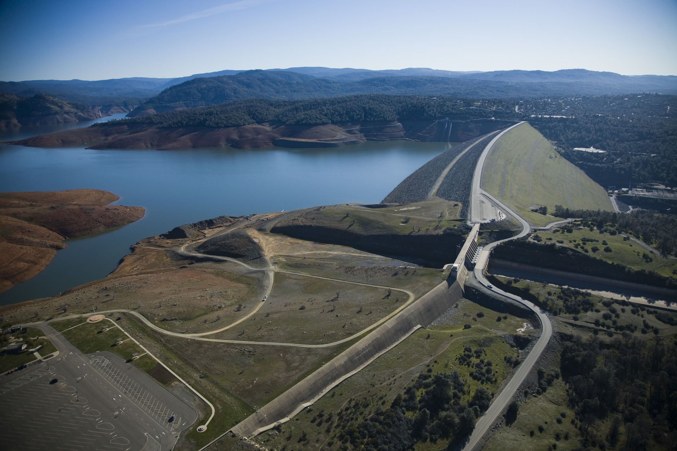
If the outflow of (emergency spillway flow + wide open electric generator flow + whatever water they decide can flow through the damaged main spillway) cannot control the rising lake level, water will overtop the dam.

That's why the National Guard is dropping bags of rocks into the eroded main spillway -- to allow more water to flow out of the lake through the normal channels, and prevent overtopping.

If water starts flowing over the main dam, it will collapse within a very few minutes. (See Teton Dam Failure, Idaho, 1976, and current aerial photos of Teton Dam site at 43.909625, -111.541608.)

As a comparison, Teton Dam had sparsely populated areas down stream and the reservoir had not yet filled for the first time. Oroville Lake is FAR larger and there are a LOT more people and agricultural areas in the path of potential Oroville flood waters.

<edit 5 mins later> Affected areas would include those that get drinking water or irrigation water from Lake Oroville, since it will not exist if the dam fails.

<edit 5 MORE mins later> .... and will affect the electric power grid, since the Oroville Dam produces about 820 megawatts of electricity.

 
Last edited by a moderator:
If water starts flowing over the main dam, it will collapse within a very few minutes.
The main dam is 20' higher than the "emergency spillway" - it is highly unlikely that will be breached. The "emergency spillway" is at the edge of a massive, gradual sloped landmass, which is going nowhere. The spillways and the hill below it may be completely devastated, but the dam itself will be fine.

1adcf8ea0b8554d8c2fa4e7c13bfd20e.jpg
Exactly! Who's bike is parked in the parking lot?

 
If water starts flowing over the main dam, it will collapse within a very few minutes.
Says who?

What is the height of the over-flow, the emergency spill way, and the dam?

Looking at the pictures of the damn, as well as the video's, it appears the main dam itself is substantially higher than the over-flow's.

Where are you getting this collapse information? No source I am aware of has even brought that issue up as a possibility.

 
Not sure about the dam itself, news reports out there were talking about fears that the spillway itself could collapse due to erosion.

 
Hope everyone remains safe.
{DickWiseCrack}I thought CA needed water.{/DickWiseCrack}
It does....in areas south of this. Kinda like what happens in Amarillo is the same thing as Austin since they're both Texas, right? ;)

Nobody hurt so far...that's great!
Good to know that everything is selling down.

Also glad to know weather is homogenous there like here.

 
The collapse worry is from the emergency spillway not the dam itself. The water was eroding at the base of the Em. spillway, if it undercut the concrete the whole section of the Em. spillway could give way and at least the top 30 of the whole reservoir would be an uncontrolled release. Not good, not good at all.

 
Last edited by a moderator:
Pictures of the repairs today from DWR.

Grouting erosion damage along the dam road where severe erosion took out the road. This prevents migration towards the main spillway.

16602024_10154435191317449_4148034981148763137_o.jpg


Rock fill along the toe of the emergency spillway...you can see the section of greatest concern just beyond the current rock fill.

16700645_10154435194917449_5992854891721016641_o.jpg


16715981_10154435195107449_3216613131515632379_o.jpg


Says who?What is the height of the over-flow, the emergency spill way, and the dam?

Looking at the pictures of the damn, as well as the video's, it appears the main dam itself is substantially higher than the over-flow's.

Where are you getting this collapse information? No source I am aware of has even brought that issue up as a possibility.
Says my training as a civil engineer, and says every professional involved with this crisis.

Yes, the heights of the spillways are set progressively higher, and both are far short of the overall dam height. However, if the outflow is smaller than the inflow, even with both spillways going whole hog, the water level will continue to rise until it overtops the dam or the surrounding terrain. And, if you haven't heard, the main spillway wasn't going whole hog.

Try it with your bathroom sink: open your drain slightly, but turn the water on full blast. You'll overflow your sink. Maybe even if your sink has an "emergency spillway" hole near the top. And, by the way, officials are lowering the Oroville Reservoir water level 50 FEET to ensure this does not happen.

However, if you look at almost every major dam failure, they are caused by erosion of the underlying soil. A small leak starts, makes it through the dam (or dam foundation) and gets bigger because it's like a pressurized hose quickly eroding the surrounding soil/rock.

Why do you think folks were freaking out about the either the normal or emergency spillway failure? Yes, either failure would cause a calamitous water flow. But, more importantly, either spillway failure would subject the dam and its foundation to erosion forces not included in the original design process. And .... both spillways exhibit EROSION FAILURE. Holy shit, Batman! The same thing that happened to both spillways could happen the the dam itself!

Like I posted earlier, look up a few dam failures and spend 30 minutes actually reading one. The Teton Dam failure (Idaho, 1976) was exactly because of erosion to the dam. Here's a photo sequence, if reading is too difficult for you you can't spend 30 minutes.

<edit, 5 mins later> Checked the Almighty Wikipedia for "Teton Dam Failure". That photo sequence went from leak to complete failure in less than 4 hours.

 
Last edited by a moderator:
Center Hill Dam in Tennessee and Wolf Creek Dam in Kentucky were both identified as "leaking" due to the karst on which they were built. Back at least 10 years ago they started projects to fill the karst with a slurry they call "grout." They try to fill the porous karst with the slurry, forming a "grout curtain." The project is described for Center Hill dam here

https://www.waterpowermagazine.com/features/featurea-history-of-karst-seepage-center-hill-dam-rehab/.

They set up a huge "plant" by the dam and started making the slurry on site, and pumping it into the karst. They ended up also building additional dam structure, widening the concrete thickness in some parts of the approaches to the dam.

They also reduced water levels in the lake by quite a noticeable amount, seriously impacting the beauty of the shoreline.

This was all supposed to take a couple of years, but they were still at it at least 7 years after the beginning of the project. I can't imagine what it cost to sort it out.

And I doubt that they really did sort it out because water levels have never been returned to earlier levels.

So ... although the problem in California is different from the one here in Tennessee, dam failures are pretty serious business. They say that if either Wolf Creek dam or Center Hill dam were to fail, that the devastation would be without precedent, and that downtown Nashville would be under water.

I am glad to hear that the California situation seems to be less of a crisis today than it looked like it would be. Still, they say that there are more rains coming ... and we have the snow melt to consider later in the Spring.

Stay safe ...

 
"Karst" is porous limestone bedrock and is often identified by sinkholes on the surface. Florida's karst produces sinkholes and lovely circular lakes from Kissimmee to Okeechobee. Kentucky's (and Tennessee's) limestone karst doesn't produce sinkholes; it produces fine bourbon and Mammoth Cave National Park.

But you're right, El Toro. The concept is the same. All dams are built on soil/rock that is porous to some degree. That porosity can lead to erosion if sufficient water pressure builds up behind the dam, or builds up in the soil due to the gazillion pounds of water in the reservoir.

I also am glad the immediate Oroville crisis has passed, but the dangers are still present until both spillways have been sufficiently repaired. That's a long-term project, however.

 
Last edited by a moderator:
Nice video, Mount Rainier. Note the smooth water flow down the top one-third of the main spillway. That's the way it should look throughout the length of the main spillway.

All the spewing, churning, and spouting is where the water hits the eroded hole that was visible yesterday. The water is uncontrolled beyond that point, but is OK if it doesn't undermine the main spillway, emergency spillway, or main dam.

There's a small town developing for media and emergency crews. Funny how there are no boats hanging around.

<edit 5 mins later> That's gotta cost a LOT of money.

<edit 5 more mins later> Am I a bad person if this is giving me an engineering boner?

 
Last edited by a moderator:
<edit 5 more mins later> Am I a bad person if this is giving me an engineering boner?

_end quote_

No. Clearly no.

 
Evacuation order is cancelled, so everyone is back home. Lots of work remains.
https://www.mercurynews.com/2017/02/14/oroville-dam-update-lake-level-continues-to-drop-tuesday-press-conference-scheduled/

Looks like this is over for now. The fact that the reservoir will be at low levels this summer for repairs, is sad as all that water will get flushed to the ocean.
Wonder if there's any white water rafting available right now? Seems like shooting down the main spillway into that friggin' hole would off the chart - like maybe a Class XXXX or somethin'
Death wish. Hell of a ride while you are still breathing. A trip over Niagara Falls would be safer.

 
Last edited by a moderator:
<blockquote class='ipsBlockquote'data-author="Uncle Hud" data-cid="1355638" data-time="1487102696"><p>

Nice video, <strong class='bbc'>Mount Rainier</strong>. Note the smooth water flow down the top one-third of the main spillway. That's the way it should look throughout the length of the main spillway.<br />

<br />

All the spewing, churning, and spouting is where the water hits the eroded hole that was visible yesterday. The water is uncontrolled beyond that point, but is OK if it doesn't undermine the main spillway, emergency spillway, or main dam.<br />

<br />

There's a small town developing for media and emergency crews. Funny how there are no boats hanging around.<br />

<br />

<<em class='bbc'>edit 5 mins later</em>> That's gotta cost a LOT of money.<br />

<br />

<<em class='bbc'>edit 5 more mins later</em>> Am I a bad person if this is giving me an engineering boner?</p></blockquote>

Ita clearly not getting in the way of your typing hand so I'd say no.

 
MrZappo posted: It's clearly not getting in the way of your typing hand so I'd say no.
Funny, ....... but true.

 
Last edited by a moderator:
Status
Not open for further replies.
Top