Looking for trip advice

Yamaha FJR Motorcycle Forum

Help Support Yamaha FJR Motorcycle Forum:

This site may earn a commission from merchant affiliate links, including eBay, Amazon, and others.

cota95

RI Beach Pop
Joined
Oct 3, 2005
Messages
2,185
Reaction score
115
Location
Lincoln, RI
I am traveling from RI to Las Vegas the first week of May 2011. Below are some routes I'm looking at traveling. Anyone see any problems with them. How about weather this time of the year. Thanks.

trip1.jpg


trip2.jpg


trip3.jpg


Last edited by a moderator:
I am traveling from RI to Las Vegas the first week of May 2011. Below are some routes I'm looking at traveling. Anyone see any problems with them. How about weather this time of the year. Thanks.
The weather can be fine (but maybe not, too?) -- I guess, if you've ridden from RI to where your route starts on the maps-shown, MO, you'll be alright? (barring storms...)

If it were me (and I have done cross-country trips in May) I'd have an alternate route about 200~300 miles south of that one... (just to try to guarantee good weather). :)

You're welcome.

 
Last edited by a moderator:
I am traveling from RI to Las Vegas the first week of May 2011. Below are some routes I'm looking at traveling. Anyone see any problems with them. How about weather this time of the year. Thanks.
The weather can be fine (but maybe not, too?) -- I guess, if you've ridden from RI to where your route starts on the maps-shown, MO, you'll be alright? (barring storms...)

If it were me (and I have done cross-country trips in May) I'd have an alternate route about 200~300 miles south of that one... (just to try to guarantee good weather). :)

You're welcome.
Understand. My last CC trip I took 40 across where there weren't any good east/west secondary roads and I figured I could drop down through OK to catch the interstate. My question I guess is are any of the routes I've chosen shut down at this time of the year?
I'm trying to complete my states map. Below is my entire trip outline.

trip4.jpg


Waw,

Big trip in front of you... How many miles (km) will be your entire trip? How long time did you reserve for? Something like this is my dream...
I haven't nailed the amount of miles down yet because the route is still fluid. I'm alloting 5-6 day out to Las Vegas where I'm meeting the wife and parking the bike with a forum member. Going to San Diego in a cage to attend a conference and do some sightseeing for a week or so and then back on the road for 9-10 days back home. I am REALLY looking forward to this trip~ :yahoo:

 
Well I got to lookin' at yer map man..

Map.jpg
Red X at the first left ya blind fecks..

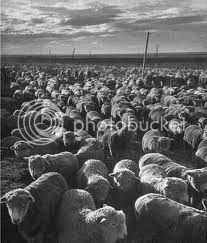
I gotta say it looks good except for the area near 69/75 interchange..

sheepom75.jpg


sheepbutts.jpg


I'll look into re-scheduling this years gathering of the herd till the week of the 17th, but no promises at this point. :)

 
I am traveling from RI to Las Vegas the first week of May 2011. Below are some routes I'm looking at traveling. Anyone see any problems with them. How about weather this time of the year. Thanks.
The weather can be fine (but maybe not, too?) -- I guess, if you've ridden from RI to where your route starts on the maps-shown, MO, you'll be alright? (barring storms...)

If it were me (and I have done cross-country trips in May) I'd have an alternate route about 200~300 miles south of that one... (just to try to guarantee good weather). :)

You're welcome.
+1 on the alternate route. I've seen snow as far south as the White Mountains of Eastern Arizona, and throughout Colorado as late as early June, let alone May. Fortunately, the Weather Service is pretty good at forecasting these days - just keep track on the internet, Weather Channel, or have a weather radio handy. Have a great trip.

 
.

Well, you DID say you were looking for advice, so. . .

I don't know what's along the route you have highlighted down through southern Colorado and then kind of zigzagging thru Utah and Arizona, but a little north of there is Utah state route 12, one of those "America's Scenic Byways," and one of the most amazing stretches of road I've ever seen. Goes through or just past five or six National Parks and National Monuments; just amazing country. Trouble is, you'll want to stop for pictures so often it's hard to make progress.

Canyonlands, Capitol Reef, Escalante Staircase, Bryce Canyon, Zion . . . It'd be a shame to miss all that.

Have a great ride.
I did take that route a couple of years ago and your are right, it's spectacular.

Thanks Mike

 
George,

Let us know when you're heading through, love to have lunch / dinner again. Room in the garage and a place to crash if you like before you head across the bridge.

Wayne

 
I did a trip last May out to California and back through a lot of the areas your going through. That time of year you will need to be prepared for extremes. I saw temperatures from 103F in Texas to 28F in Nevada. Got stuck in Winslow AZ because a dust storm had 40 shut down. Tornados in KS and OK and some serious snow crossing Wolf Creek Pass on Colorado 160. Not trying to talk you out of it at all just be prepared for anything that early in the year. Wish I was going.

 
The scale and jpg format of your maps doesn't really make it easy to suggest alternatives or even tell where all these waypoints are. Posting a Route on Google Maps or something similar might be more interesting, and can even be interactive. I did a similar cross-country this past june-july and the choices are very hard to make. At some point, assuming time and money are finite, it pays to get on the super slab or a major US highway and make some time over the more boring stretches, to allow more time and diversions in the more interesting areas.

Looks like you are going through Durango, Silverton, Cortez in Colorado. There are some really nice rides off that route worth doing. I tend to agree the Utah SR12 is more interesting than the southwest desert in Arizona, and south Nevada. Once you are done in Las Vegas, do yourself a big favor and move your trip west to US395 in California. Include Death Valley only after checking weather reports as temperatures can easily exceed 115 that time of year, but the trip from Lone Pine north into Oregon, then resuming your route will be a lot nicer than a grueling dirty desert run up US95. If you do that, don't forget to fill up in Lakeview OR. There is no fuel (or anything else) for another 130 miles.

If you have an iPhone, check out the RadarScope application. Kinda pricey at $10, but it enabled me to see the weather in real time and make decisions based on storm intensity and direction. I'll ride through most weather, but found myself in the southwest tail of a classic supercell spitting out tornados on the Indiana Illinois border. That was a good time to stop for fuel and coffee. I also found that elevations above treeline are not an ideal place to be during lightning storms.

 
This one might be closer to home for you, George. You can even hit this one before you leave. ;)

Connecticut Sheep Breeders Association Sheep and Wool Festival

"started in 1909 by the CT Sheep Breeders Association, as a program “to promote the keeping of sheep in Connecticut”

Who knew!

Thanks for sharing with these guys Chris.

I'm already on the mailing list,and have a shed reserved ;)

George,

Let us know when you're heading through, love to have lunch / dinner again. Room in the garage and a place to crash if you like before you head across the bridge.

Wayne
Just make sure you allot about two hours to cross that blasted bridge :eek: :lol:

 
The scale and jpg format of your maps doesn't really make it easy to suggest alternatives or even tell where all these waypoints are. Posting a Route on Google Maps or something similar might be more interesting, and can even be interactive.

Looks like you are going through Durango, Silverton, Cortez in Colorado. There are some really nice rides off that route worth doing. I tend to agree the Utah SR12 is more interesting than the southwest desert in Arizona, and south Nevada. Once you are done in Las Vegas, do yourself a big favor and move your trip west to US395 in California. Include Death Valley only after checking weather reports as temperatures can easily exceed 115 that time of year, but the trip from Lone Pine north into Oregon, then resuming your route will be a lot nicer than a grueling dirty desert run up US95. If you do that, don't forget to fill up in Lakeview OR. There is no fuel (or anything else) for another 130 miles.
Thanks for the suggestions. I will see if I can work with google maps. I plan on driving the rt 12/Utah with the wife in the cage. The last time I ran through here I was told to stay away from 395 because of snow in the mountains. Am I thinking of the same section? Where is Lone Pine?

 
Thanks for the suggestions. I will see if I can work with google maps. I plan on driving the rt 12/Utah with the wife in the cage. The last time I ran through here I was told to stay away from 395 because of snow in the mountains. Am I thinking of the same section? Where is Lone Pine?

Lone Pine is south of Bishop, CA and is at the junction of 190 (out of Death Valley) and 395, and in the shadow of Mt Whitney, the highest peak in the lower CONUS. US395 in late May keeps to the lower elevations except for a couple moderate passes north of Mammoth. It is a well maintained road and will be clear unless an unusual late-season storm is ongoing. It is in the rain-shadow of the Sierra and doesn't pile up like the high passes (Tioga, Sonora, Ebbetts, Echo and Donner). It may be one of the most stunningly scenic roads along the front of a sustained 300 mile mountain range.

Here is a US395 roadside shot north of Lone Pine taken April 3, 2009. Not so bad or snowy. You will have fewer problems here than some of stretches through Idaho and Montana farther north.

1DeathValley096.jpg


Last edited by a moderator:
Top