Spud
Well-known member
I've got a day to ride from Tonopah to Vegas. What route would you suggest? I've never been to Death Valley...
Thanks.
Thanks.


Depending on the conditions, it might be possible to beat google's 4 hour 10 minute time estimate for that stretch....
For flat-out fun....it's hard to beat the 260 mile version that includes Rachel and the Little A'Le'Inn on the E.T. Highway.

+1, Good point, "Warp Speed" is possible, and often desirable, on that route, which may be a bit faster than Google's estimate.Depending on the conditions, it might be possible to beat google's 4 hour 10 minute time estimate for that stretch....
For flat-out fun....it's hard to beat the 260 mile version that includes Rachel and the Little A'Le'Inn on the E.T. Highway.


I'm with you Iggy. Done that route a couple of times, just make sure to gas up in Tonopah as gas in Rachel is sometimes iffy. Great road also if you plan to turn off east to Caliente.For flat-out fun....it's hard to beat the 260 mile version that includes Rachel and the Little A'Le'Inn on the E.T. Highway.
Oh yeah !!Depending on the conditions, it might be possible to beat google's 4 hour 10 minute time estimate for that stretch....
For flat-out fun....it's hard to beat the 260 mile version that includes Rachel and the Little A'Le'Inn on the E.T. Highway.
You mean Area 51?? Don't tell me there's an area 53 too??Don't forget to check out the Area 53 aliens at the restaurant in Rachel. And watch out for low-flying planes - the road signs will remind you.
Small world! I'm planning on going from IF to Tonapah Saturday, Death Valley Sunday....but still trying to finalize work issues...Spud,I just checked the weather and Furnace Creek, Death Valley is supposed to be about 80º today............Perfect. Interesting you're in Tonopah, I'll be there this Friday via FJR, and plan to visit Death Valley if it doesn't get too hot by then!
The Nevada Test site does have areas 1-30 covered well here. We have an LD rally master that knows some of those areas well from his day job.You mean Area 51?? Don't tell me there's an area 53 too??Don't forget to check out the Area 53 aliens at the restaurant in Rachel. And watch out for low-flying planes - the road signs will remind you.
")
You can carry on through Jubilee pass. It is an awesome ride. Iggy's route with this slight modification is the way to go. IMHOI'm definitely more interested in Iggy's first suggested route, as I want to go into the park (I've also ridden the ET before)....
Is there a reason for the out-n-back on the Badwater Road section? It looks like you could go straight through to the 178 (Jubilee Pass Road) further south, then into Pahrump. It looks like Badwater is paved all the way (?)
Thanks for the quick suggestions. Can't wait to feel the 100 degree weather down there (snowing here today)....
That would be 200 miles Tonopah to Pahrump, so gas situation would be OK...
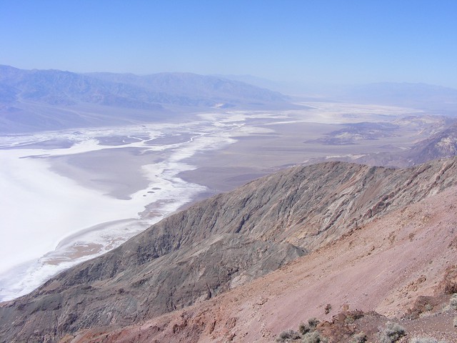
I had it that way so ya could go to dantes view on the way outIs there a reason for the out-n-back on the Badwater Road section? It looks like you could go straight through to the 178 (Jubilee Pass Road) further south, then into Pahrump. It looks like Badwater is paved all the way (?)

Enter your email address to join: