You are using an out of date browser. It may not display this or other websites correctly.
You should upgrade or use an alternative browser.
You should upgrade or use an alternative browser.
What's the Weather like where YOU are today?
- Thread starter LKLD
- Start date

Help Support Yamaha FJR Motorcycle Forum:
This site may earn a commission from merchant affiliate
links, including eBay, Amazon, and others.
bigjohnsd
2021 BMW R1250GSA
It was a beautiful Fall day here today, 74F andclear as a bell with no wind.
It will Snow tomorrow
It will Snow tomorrow
ionbeam
2 FUN
Cool, with showers that just moved out. It's that time of year in New England. It was a good weekend for a slow train ride through the Franconia Notch area. This morning it was 34 degrees when I rode to work.


Last edited by a moderator:
BwanaDik
Well-known member
Sucks.....Fcuking hot again, 80+ at 6:00 AM and 91% humidity. Getting pretty tired of waiting for Fall

luvtoride
My Indian name is "Pants On Fire"
Lovely pic, Alan.Cool, with showers that just moved out. It's that time of year in New England. It was a good weekend for a slow train ride through the Franconia Notch area. This morning it was 34 degrees when I rode to work.

El Toro Joe
FYYFF
78 and sunny here, for my ride home today...Woohoo!!!

$26.99
$29.99
Alepo Genuine Sheepskin Leather Gloves For Men, Winter Warm Touchscreen Texting Cashmere Lined Driving Motorcycle Gloves (Black-L)
guizhouxuanweishangmaoyouxiangongsi

$98.16
25-1775 Replacement for All Balls Wheel Bearing Kit (25-1775) for Yamaha FJR1300 03-16 FJR1300ES 14-18
Otisdelilah Auction

$24.37
Fuel Tank Sticker Motorcycle Stickers for Yam&aha FJR1300 FJR 1300 Tank Pad Protector Decal Emblem Side Fairing Symbol Adventure
nanyangshixianpushangmaohanggerenduzi

$184.79
$209.99
Milwaukee Leather SH1408 Men's Sporty Crossover Vented Black Motorcycle Leather Scooter Jacket - Large
Amazon.com

$91.99
Edwards Maintenance Kit fits 2003-2020 Yamaha FJR1300 Sport Touring
Edwards Motorsports & RV's

$16.19
$17.99
MELASA Fleece Lined Winter Cycling Beanie with Holes for Glasses - For Men, Women
HNXCHUANG

$64.99
Edwards Oil Change Kit fits 2003-2020 Yamaha FJR1300 Sport Touring
Edwards Motorsports & RV's

$17.99
$19.99
MOREOK Winter Gloves -10°F 3M Thinsulate Warm Gloves Bike Gloves Cycling Gloves for Driving/Cycling/Running/Hiking-Black-L
MOREOK-US (Ships from USA)

$11.99
$16.99
QUKOPSE Winter Leather Gloves for Men,Touchscreen Snow Driving Gloves with Cashmere Lining for Motorcycle Driving Riding
enshizhouchonglinshangmaoyouxiangongsi

$159.99
FLAVOR Men Brown Leather Motorcycle Jacket with Removable Hood (Large (US standard), Brown)
FLAVOR Leather
bigjohnsd
2021 BMW R1250GSA
Got about 1/2 inch of the dreaded white stuff last evening,It's brilliantly sunny now, no wind, no clouds, and the snow is long gone

Last edited by a moderator:
Bugnatr
Well-known member
Going to be wet this weekend....inches of wet.
First real rain since May so it will be a welcome relief from fire season.

First real rain since May so it will be a welcome relief from fire season.
FJRay
Well-known member
Supposed to get a lot of rain here. I've got a good view from the fifth floor of the hospital.

NTXFJR
Well-known member
Riding weather's been about as good as it gets for our area the past few days. 78/61 for tomorrow.
TomInPA
Well-known member
I had Lyme's Meningitis in the summer of 2013 and missed the entire riding season. I feel your pain bro. At least you're looking at an early winter storm rather than summer thunder.Supposed to get a lot of rain here. I've got a good view from the fifth floor of the hospital.

I hear ruebens are good for the colon?
Bungie
FrostBack #2 - IBA # 44620
34F and overcast.
Took the truck to work.
Took the truck to work.
El Toro Joe
FYYFF
What a difference a day makes...yesterday sunny and 78, today rainy, overcast, and a high of 56.
NTXFJR
Well-known member
Sigh, it's supposed to be rainy with thunderstorms here today. But..... it's Friday!
Last edited by a moderator:
Bungie
FrostBack #2 - IBA # 44620
Supposed to be 15C (about 60F) tomorrow and partly cloudy. I've already told Line I'm riding tomorrow.
wheatonFJR
...
warm, then cold at night. same thing over and over...blah, blah, blah.
Kaismo
Well-known member
Was going to take Friday off for a run down to College Station; however the weather did not cooperate and it's raining up by Fort Worth. Postpone the ride till tomorrow and I will be on a whole day "adventure to nowhere" ride on Saturday.
escapefjrtist
Searching for Dry Roads
Lots of rain & heavy winds...not a good combination for the PNW.
--G
--G
Bugnatr
Well-known member
3 inches of wet today, 4-5 more by Monday. First real rain since May.
No more fire season


No more fire season
Last edited by a moderator:
redneckj
Well-known member
A train of storms will pound the northwestern United States with flooding, dangerous surf and hurricane-force winds into early next week.
The most severe impacts will be felt from southwestern British Columbia through western Washington and Oregon and into northern California as several Pacific storms barrel onshore through Tuesday.
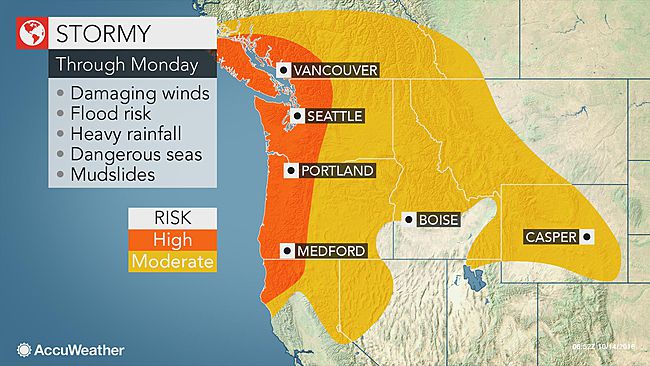
Residents in and around these areas should be aware of the threat for urban and coastal flooding, mudslides, washed-out roads, power outages, property damage and travel disruptions during the onslaught.
The combination of rain, wind and poor visibility could make travel very hazardous on area highways.
The National Weather Service in Portland, Oregon, confirmed two tornadoes along the Oregon coast early on Friday. One was reported in the town of Manzanita, while the other touched down in the community of Oceanside.
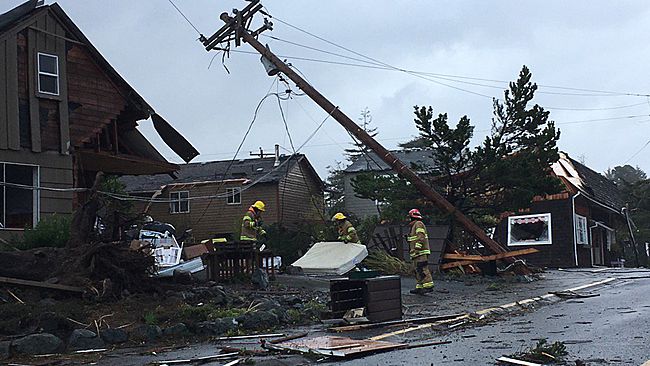
A waterspout moved onshore near Manzanita, Oregon, Friday morning and caused some damage to the town. (Photo/Twitter/@molfamily via Storyful)
On Thursday night, the winds proved to be too strong for many trees and power lines across the region. Over 7,800 Portland General Electric customers were without power around 3 am PDT on Friday. That number has slightly improved since then and is around 2,000 customers as of 10:30 am PDT Friday. In Lebanon, Oregon, roughly 1,500 customers were without power as of this same time.
Farther north, gusty winds are also causing issues. In the Seattle area, more than 35,000 customers were without power as of 5 p.m. PDT Friday, according to Puget Sound Energy.
Once-Super Typhoon Songda to unleash hurricane-force conditions this weekend
As quickly as the first storm exits, the second, more powerful storm will follow on its heels from Saturday to Sunday.
This next storm will contain the remnant circulation of once-Super Typhoon Songda, which curved away from Japan earlier this week.
While the storm is not expected to be tropical in nature by the time it reaches the Pacific Northwest, the impacts could still be similar to that of a hurricane, according to AccuWeather Senior Meteorologist Alex Sosnowski.
Gusts from 75 to 100 mph will occur in some coastal areas. Additional tree and power line damage and power outages are likely.
"The storm this weekend could hit some areas like a sledgehammer," Sosnowski said.
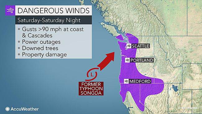
"The heaviest rain and highest winds will come onshore Saturday afternoon along the Washington, Oregon and northern California coasts," according to AccuWeather Senior Meteorologist Dan Pydynowski. "A general 2 to 4 inches of rain will fall across the region, with higher amounts in the coastal ranges."
"Flooding will certainly be a concern after much of this same region is getting inundated with several inches of rain to end the workweek," he added.
Residents should clear debris out of storm drains to help prevent an overflow of water onto streets and lands.
Motorists should prepare for slow travel and possible road closures. Never attempt to drive through a flooded roadway as the water may be higher than it appears and the roadway underneath could be compromised.
The most severe impacts will be felt from southwestern British Columbia through western Washington and Oregon and into northern California as several Pacific storms barrel onshore through Tuesday.

Residents in and around these areas should be aware of the threat for urban and coastal flooding, mudslides, washed-out roads, power outages, property damage and travel disruptions during the onslaught.
The combination of rain, wind and poor visibility could make travel very hazardous on area highways.
The National Weather Service in Portland, Oregon, confirmed two tornadoes along the Oregon coast early on Friday. One was reported in the town of Manzanita, while the other touched down in the community of Oceanside.

A waterspout moved onshore near Manzanita, Oregon, Friday morning and caused some damage to the town. (Photo/Twitter/@molfamily via Storyful)
On Thursday night, the winds proved to be too strong for many trees and power lines across the region. Over 7,800 Portland General Electric customers were without power around 3 am PDT on Friday. That number has slightly improved since then and is around 2,000 customers as of 10:30 am PDT Friday. In Lebanon, Oregon, roughly 1,500 customers were without power as of this same time.
Farther north, gusty winds are also causing issues. In the Seattle area, more than 35,000 customers were without power as of 5 p.m. PDT Friday, according to Puget Sound Energy.
Once-Super Typhoon Songda to unleash hurricane-force conditions this weekend
As quickly as the first storm exits, the second, more powerful storm will follow on its heels from Saturday to Sunday.
This next storm will contain the remnant circulation of once-Super Typhoon Songda, which curved away from Japan earlier this week.
While the storm is not expected to be tropical in nature by the time it reaches the Pacific Northwest, the impacts could still be similar to that of a hurricane, according to AccuWeather Senior Meteorologist Alex Sosnowski.
Gusts from 75 to 100 mph will occur in some coastal areas. Additional tree and power line damage and power outages are likely.
"The storm this weekend could hit some areas like a sledgehammer," Sosnowski said.

"The heaviest rain and highest winds will come onshore Saturday afternoon along the Washington, Oregon and northern California coasts," according to AccuWeather Senior Meteorologist Dan Pydynowski. "A general 2 to 4 inches of rain will fall across the region, with higher amounts in the coastal ranges."
"Flooding will certainly be a concern after much of this same region is getting inundated with several inches of rain to end the workweek," he added.
Residents should clear debris out of storm drains to help prevent an overflow of water onto streets and lands.
Motorists should prepare for slow travel and possible road closures. Never attempt to drive through a flooded roadway as the water may be higher than it appears and the roadway underneath could be compromised.
Similar threads
- Replies
- 18
- Views
- 1K
- Replies
- 6
- Views
- 743
- Replies
- 19
- Views
- 1K




![Decrum Motorcycle Jacket Men - Mens Leather Jacket | [1100065] Austin Brown, XL](https://m.media-amazon.com/images/I/41HqZSRj6LL._SL500_.jpg)


