If you wish that Basecamp handled individual files like Mapsource did ...

Yamaha FJR Motorcycle Forum

Help Support Yamaha FJR Motorcycle Forum:

This site may earn a commission from merchant affiliate links, including eBay, Amazon, and others.
If you right click on the original route, look down the list of commands. You should see "cut, copy & DUPLICATE". Click duplicate and a second file name will appear, usually with a 1 behind the name. You can do anything you want to this file, change it, rename it, move it to another folder or whatever. The original file will not be changed.
Oh, "duplicate". In an earlier post I read that as duplicate, i.e., copy, not the command "duplicate". I'll try it.

Are you familiar enough with BC to answer more questions? For the life of me I can't find some answers.
I'll try if I can.

 
I'll try if I can.
I'd appreciate it.

One of the things I haven't figured out- why can't I see my stuff? I have a list folder selected (and highlighted) in the top left 'Library' box. A route is on the map. If I put my cursor on it it gives me the name of the route. But I can't do anything with it. The bottom left box is empty. I have waypts on this route- a couple gas stations and restaurants- but nothing is in the box so I can't pick/edit anything. What am I doing wrong?

ETA: I tried adding a screen shot so you could see what I'm talking about but after 5 minutes of watching the little wheel go round and round and round I gave up.

 
Last edited by a moderator:
I'll try if I can.
I'd appreciate it.

One of the things I haven't figured out- why can't I see my stuff? I have a list folder selected (and highlighted) in the top left 'Library' box. A route is on the map. If I put my cursor on it it gives me the name of the route. But I can't do anything with it. The bottom left box is empty. I have waypts on this route- a couple gas stations and restaurants- but nothing is in the box so I can't pick/edit anything. What am I doing wrong?

ETA: I tried adding a screen shot so you could see what I'm talking about but after 5 minutes of watching the little wheel go round and round and round I gave up.
Just below the bottom left box are 8 data filters. Click the one on the far left and everything should show up. I think you might have click one of the buttons that do not have any info in it. If the 8 buttons are not there click on the button that looks like a usb plug. It should say "show data filters" or "hide data filters". You want to have them showing. The one on the far left shows all data, the next shows waypoints and the next is for routes.

 
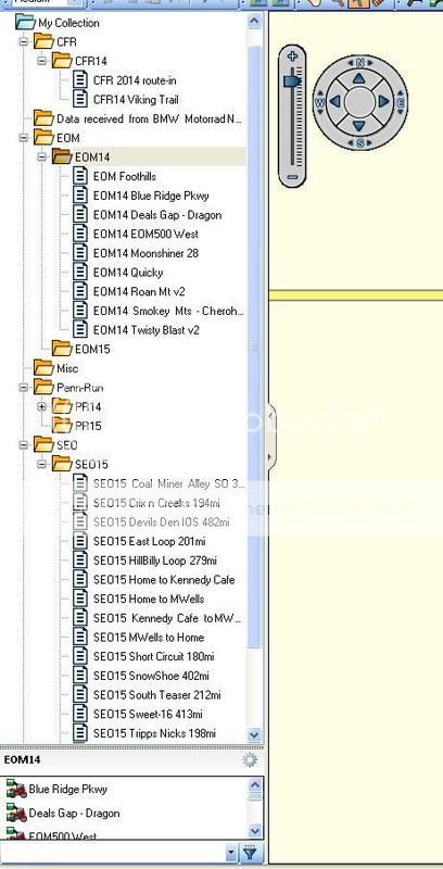
For the life of me, I cannot figure out the confusion of the File System within BaseCamp. So I took a snapshot of mine. I'll easily explain my theory(s) below...
BC_file-system_zps1z7ggvbw.jpg


Very Normal File system .....to me anyways?

Notice, I keep a "parent" folder to hold the "child" folders. So i.e. there are several "EOM's or NAFO's" etc. You would make a parent folder for lets say "EOM", then within that folder, make the child folder(s) of those years i.e. "EOM13, EOM14" etc. Put (or make) your routes (or tracks) of each in the correct years folder. This keeps a clean and easy file system for your routes, and, you can move Files (or Folders!) around, re-name etc and with ease!

A common error for newb's is that they don't "highlight" the folder (parent) that they want to make another folder within (child). Another tip is naming your Routes; Keep it definitive but short. This way it doesn't roll-off your GPS' select screen, and you can pretty much get the idea within 6-8 words. Oh, and with BC, highlight any Folder or File prior (that you want to deal or work with(in), this is the trigger to basic BC success!

There yas go, file system Top Speed-101 and very easy-peasy!
Don't be fooled.

This NOT a file system. It is a database with those "folder" looking things acting as pointers to data. They are not your Mama's files!

If that database gets corrupted, you will lose everything in it, not just the content of one folder, or one file .... there is only one file!

MapSource and Streets and Trips both work very differently. They create a single .gdb or .est file for every trip you create. Lose one, and you just lose one.

It is critical that you back that file up regularly, and try to keep multiple copies. Also, as the file gets bigger it gets increasingly cumbersome. It slows down loading and saving, and it is a structural fault that I hope Garmin addresses in future releases.

ps ... One workaround is to export the contents of each "folder" as a .gpx file. That would contain the routes and waypoints you have in each folder and if you lose the database you could re-create it from those files, simply by importing them into BC.

 
Last edited by a moderator:
Just below the bottom left box are 8 data filters. Click the one on the far left and everything should show up. I think you might have click one of the buttons that do not have any info in it. If the 8 buttons are not there click on the button that looks like a usb plug. It should say "show data filters" or "hide data filters". You want to have them showing. The one on the far left shows all data, the next shows waypoints and the next is for routes.
Oh. That was pretty stoopit wasn't it? DuhHuh
weirdsmiley.gif
.

Next question then:

Say I'm working along making a route by picking via points. Or shaping points, whatever they're called. Not waypoints b/c I'm not marking spots with flags, just picking a spot to go to/through with a black dot. So I pick a spot and I don't like it. In MapSource I could just ctrl+Z and continue on. In BC I can't. What happens is if I ctrl+Z the pointer goes to the zoom mode. In order to undo the spot I erroneously picked I have to edit/undo. But then my my map isn't highlighted anymore so I can't continue on with my route. I have to click in the map area to highlight it but then my route is discontinued. How do I continue on just as if nothing happened? The insert tool doesn't work- it sends me to another spot then back again. I can use the move tool to move the last via pt I picked but then I still have to go back and insert more pts to get the route I want, doing the work twice to make one route. Is there a way to not have to go back to the beginning and start all over to have one continuous route instead of 2 or 3 or 4 piecemeal routes that I have to try and file/remember correctly?

 
In the above example, you actually are creating waypoints. Everytime you click on the map with the Route Tool, it creates a WP right where you clicked.

You don't have to "undo" them if you make a mistake. Just go ahead and complete the route. When that is done, open the route properties by double-clicking the route (with the "hand" tool), then simply delete the points you do not want. The route will re-calculate automatically.

Actually, inserting points, deleting points, splitting and joining routes really is a very simple process when you get the hang of it.

 
Last edited by a moderator:
In the above example, you actually are creating waypoints. Everytime you click on the map with the Route Tool, it creates a WP right where you clicked.
So next question: is there really a difference between waypoints, shaping points, and via points? They seem to be for different things but people seem to be using the terms interchangeably. It seems I don't understand the terminology. I've asked before- is there a glossary of terms available? If way, shaping, and via pts are all the same thing then a) why different names, and 2) why different symbols? Is there a time it would be more helpful to use one than the other?

I've tried making a route with via pts- never comes out right so I have to keep adding and adding and adding pts until the gps is nearly constantly giving directions. If I use waypoints the map is so cluttered from symbols it's unreadable.

You don't have to "undo" them if you make a mistake. Just go ahead and complete the route. When that is done, open the route properties by double-clicking the route (with the "hand" tool), then simply delete the points you do not want. The route will re-calculate automatically.
Ah, I see. Then I can go back and insert, move or erase. I think maybe in the opposite order. I'm finding that it is really, really important in which order you do things. If you don't do it right you'll go round and round and round. Hence the frustration of it never coming out right and having to do the edits over and over and over.

Actually, inserting points, deleting points, splitting and joining routes really is a very simple process when you get the hang of it.
I'm trying to make a single route. That's it. Inserting, erasing (a BIG sticking point to me!!!) and moving I'm ok with. The other things you mention, whatever the hell they are, however the hell they're done, seem totally and completely irrelevant to me right now. Hell, I can't seem to make a complete, uninterrupted route that's a continuous straight line on a single continuous 2 lane road. The sticking point? When you say "deleting points". When someone says delete a point, I look for a "deleting" tool. There ain't one. More frustration. I know, it's really OCD but when you say copy, I copy. I don't duplicate, I copy. Same thing with delete vs. erase. When you say delete I hit the delete key. If you want me to erase a point with the erase tool, you have to say erase. I'm a newb and I will take what you say literally.

 
For the life of me, I cannot figure out the confusion of the File System within BaseCamp. So I took a snapshot of mine. I'll easily explain my theory(s) below...
BC_file-system_zps1z7ggvbw.jpg


Very Normal File system .....to me anyways?

Notice, I keep a "parent" folder to hold the "child" folders. So i.e. there are several "EOM's or NAFO's" etc. You would make a parent folder for lets say "EOM", then within that folder, make the child folder(s) of those years i.e. "EOM13, EOM14" etc. Put (or make) your routes (or tracks) of each in the correct years folder. This keeps a clean and easy file system for your routes, and, you can move Files (or Folders!) around, re-name etc and with ease!

A common error for newb's is that they don't "highlight" the folder (parent) that they want to make another folder within (child). Another tip is naming your Routes; Keep it definitive but short. This way it doesn't roll-off your GPS' select screen, and you can pretty much get the idea within 6-8 words. Oh, and with BC, highlight any Folder or File prior (that you want to deal or work with(in), this is the trigger to basic BC success!

There yas go, file system Top Speed-101 and very easy-peasy!


ps ... One workaround is to export the contents of each "folder" as a .gpx file. That would contain the routes and waypoints you have in each folder and if you lose the database you could re-create it from those files, simply by importing them into BC.
Exactly what I do. I export to a folder on my computer as well as export it to my GPS. No problems, no lost anything, but I'm not going to try either.

 
A Waypoint and a Shaping point are the same thing. The only difference is that shaping points are not "announced". They are used to force the software to calculate a route on roads you choose. "Via" Points don't exist. If you are going "via", you are going to a waypoint.

All points in BaseCamp can have any symbol you choose to attach to them. The default is a blue flag, but that can be changed either singly or en-masse in WP properties.

Yes, you can freely insert and delete. You can do it with the tools on the toolbar, or in the Route Properties that you open by double-clicking on a route.

You can make a route, with the route tool, between two points in about 5 seconds. You can then use the "Insert Tool" to add any points along the route, by selecting the tool then dragging the route to the new point.

 
Route Terminology

  • POI: A formal Point Of Interest, or entry in the POI database including name, location, and other useful information.
  • Waypoint: An arbitrary location saved in a database for future reference.
  • Via Point: Any database POI or Waypoint included in a route other than the Start or Finish points.
  • Shaping Point: Any position along a route requiring a change in direction that does not otherwise exist in any database.

BTW- You can have un-announced WP's, depends on how you compile the route.

 
Route Terminology
  • POI: A formal Point Of Interest, or entry in the POI database including name, location, and other useful information.
  • Waypoint: An arbitrary location saved in a database for future reference.
  • Via Point: Any database POI or Waypoint included in a route other than the Start or Finish points.
  • Shaping Point: Any position along a route requiring a change in direction that does not otherwise exist in any database.

BTW- You can have un-announced WP's, depends on how you compile the route.
Your definition of "Shaping Point" is not quite how BaseCamp handles them.

In route planning, a "Shaping Point" is a point created by the user that is not announced in the directions, nor used for calculations of things like Time of Arrival or Distance to next Point, etc. You can make ANY point in a route into a shaping point by simply clicking the "Do Not Alert" in the properties.

The shaping points referred to in your bulleted list are simply internal program markers the software uses to calculate the turns.
Well, I guess you know more than Garmin then! ;)

...that statement was taken from Garmins Base Camp / wiki library-knowledge base.

 
Last edited by a moderator:
Yeah, you might. I know no one who uses that definition of "Shaping Point". No idea what those Wiki writers were thinking :D

 
Yeah, you might. I know no one who uses that definition of "Shaping Point". No idea what those Wiki writers were thinking :D
On the contrary. Join up on the base camp forum, you'll hear "Shaping Points", and quite frequently.

 
Last edited by a moderator:
Yes, I know about shaping points. Whatever the Wiki might say, they are NOT the points created by the software when it makes a route.

Shaping Points are points created by the user to make sure that the route shapes to the desired path. They are waypoints, that the user creates to force the route along a particular path, and set to not announce when you approach or pass them.

Garmin does not own the terminology, and in the many years I have been doing this, the definition you posted above is the first time I have ever heard them described thus. Garmin has attempted to change the naming convention, and like many other things Garmin gets wrong, they need to quit.

 
My preferred method for creating routes is to use the new route tool and create the start and finish point of the route. Then use the insert tool to drag the route to the roads you want to include. Place the via point just AFTER a turn. That way the turn shows up on the gps first and you can ignore the via point after the turn (especially if you turn off the alert on arrival in route properties). The rubber band looking line that appears while using the insert tool can be turned off by hitting the "esc" key on your keyboard. That will allow you to pick the sections of the route that you want to alter.

A note about via points: There is a limit to how many the Garmin GPS can use. Too many via points and the GPS will split the route into sections. Setting the via points to "don't alert on arrival" in route properties helps overcome this limitation in the GPS. This might just be an issue with the units that use Trip Planner. I did not notice this happening on my older 550 that used the Route feature.

 
My preferred method for creating routes is to use the new route tool and create the start and finish point of the route. Then use the insert tool to drag the route to the roads you want to include. Place the via point just AFTER a turn. That way the turn shows up on the gps first and you can ignore the via point after the turn (especially if you turn off the alert on arrival in route properties). The rubber band looking line that appears while using the insert tool can be turned off by hitting the "esc" key on your keyboard. That will allow you to pick the sections of the route that you want to alter.
A note about via points: There is a limit to how many the Garmin GPS can use. Too many via points and the GPS will split the route into sections. Setting the via points to "don't alert on arrival" in route properties helps overcome this limitation in the GPS. This might just be an issue with the units that use Trip Planner. I did not notice this happening on my older 550 that used the Route feature.
This is good advice. Never put a waypoint right on an intersection, always go slightly beyond in the direction of travel. Also, if you use shaping points, however they are defined, on interstates and divided highways, always zoom right in and check they landed on the correct side of the road. DAMHIK

With respect to route length .... Most Garmin units can cope with up to about 1500+ miles. Much beyond that and they can't give full directions, distances, etc until they recalculate well into the ride.

I found the best answer is to split the route into "bite-sized" chunks, something BaseCamp makes it very easy to do.

Another point ... If you like to save your "Tracks" for later review, something that is useful for learning from rally performance because the tracks do not lie whatever your memory tells you, then there is a limitation. Most units can only store 10 000 track points before they start over-writing. Again this is around 2000 miles worth. If you want more than that the way to do it is simply to download the tracks to a laptop every 24 hours, them join them later.

ps .... Don't put waypoints directly on overpasses or bridges over a road (or the road under the bridge) ... go to one side or the other. If you do, you might get lucky and you might end up with a long diversion onto a bridge you were supposed simply to go under :D There is a way to do this if you have a bonus location in a difficult place, but it involves using Google Earth to place the point then export and import into BC ... Usually it's not worth the effort.

 
Last edited by a moderator:
You guys are killin' me, mostly by telling what I can do without giving very specific step-by-step directions of how to do and without explaining WTH you are talking about. Just 'cause YOU know what you're talking about doesn't mean EVERYONE knows what you are talking about.

And argue semantics if you want, but when someone says, " "Via" Points don't exist" and I'm looking at my computer screen and it says "Edit Via Point" on a drop down menu then someone- either the BC software or the poster, I'm not saying which
no.gif
- is full of dookie.

 
This is good advice. Never put a waypoint right on an intersection, always go slightly beyond in the direction of travel. Also, if you use shaping points, however they are defined, on interstates and divided highways, always zoom right in and check they landed on the correct side of the road. DAMHIK
I found this out (the intersection part) with MapSource and have continued the habit as you describe. The 2nd part is crucial in BC as it is designed for off-road use too. It doesn't mind trying to send you down into the woods. The tutorial in another thread addresses this specifically.

With respect to route length .... Most Garmin units can cope with up to about 1500+ miles. Much beyond that and they can't give full directions, distances, etc until they recalculate well into the ride.
I found the best answer is to split the route into "bite-sized" chunks, something BaseCamp makes it very easy to do.
"Bite-sized" is different for different people. I'm not a rally guy so my bite-sized will differ from yours significantly I imagine. I've been working with the joining of routes as my nuvi will only store 10 routes at a time. I wanted to have at least 13 for an upcoming trip. Oops....

I can find nothing in the help about splitting a route. Is that the specific term I should be looking for? Or is it a command function of a different name? Some specific directions would be nice as I can find nothing.

 
Top