iPhone 5 as GPS?

Yamaha FJR Motorcycle Forum

Help Support Yamaha FJR Motorcycle Forum:

This site may earn a commission from merchant affiliate links, including eBay, Amazon, and others.
cons: weather, vibration, connectivity, costpros: none
Another con is the iPhone isn't hardened for weather (obviously) but also not for the vibrations of a motorcycle.I have friends who work for Apple and, in particular, the department that torture tests iPhones and while they say they personally would stand behind the iPhone's ability to withstand the vibrations of a bike, the company doesn't warranty it.

With so many other (and mostly better) options, I wouldn't use an iPhone as a GPS.

 
OK - I'm getting there ! GPS in AquaBox, charging from Gen-II cigarette outlet via port in Aquabox. Mount using RAM mount.
I would have liked to use the RAM mount that bolts to the clutch reservoir --- https://www.rammount.com/CatalogResults/PartDetails/tabid/63/partid/082065077045066045049055052085/Default.aspx

But I have an AE, so no clutch reservoir. I guess I could mount it over on the RHS brake reservoir instead ... but that leaves a trailing wire from the glovebox on the LHS fairing

Anyone got a good suggestion for a RAM attachment point for an 09 AE ?
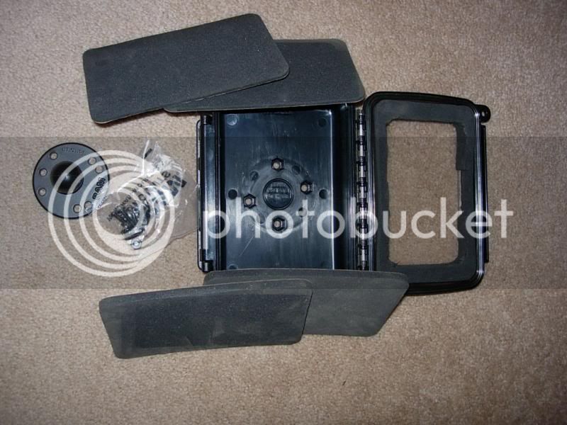
Hoo boy! There are so many mounting and powering options that it's really hard to choose. Take a few to look over a few threads to see some of the options. The last link shows my mounting and powering choice and how I use the baggie in the rain. If you decide you may be interested in the AquaBox I have it (for gps cradle wide), 4 extra foam pads, a 1" ball mount and the screws. I'll gladly send pics. Lemme know!

https://www.fjrforum.com/forum//index.php/topic/150160-gps-mounting-location/?hl=garmin

https://www.fjrforum.com/forum//index.php/topic/149895-looking-to-get-a-new-gps-what-do-you-own/?hl=garmin&do=findComment&comment=1026651

https://www.fjrforum.com/forum//index.php/topic/148063-gps-mounting/?hl=garmin&do=findComment&comment=997987

 
I'm going for the Wyn ball mount using the fuel tank mount points - that is on order now, so all I need is the arm and the Aquabox - how much do you want for yours ?

 
I just tested my iPhone 5 on a day trip to Shenandoah. It was mounted in a Ram mount on the reservoir. Wasn't expecting rain.

AGPS isn't a problem. It uses the cell towers to help pinpoint your position. When not available, it works just off of the GPS satellite signals.

I lost cell service a couple of times, but the vector based mapping loaded fast enough so I didn't lose any mapping.

The power cable was long enough to reach from the 12V source without a problem.

One thing I did notice was that the constant switching in the switchbacks caused it to get confused as to which direction I was pointed. Not a huge problem.

While not ideal, it will work in a pinch.

 
I'm going for the Wyn ball mount using the fuel tank mount points - that is on order now, so all I need is the arm and the Aquabox - how much do you want for yours ?
Here's what I got:

the box w/ 1 thick foam cut to hold my Garmin; 2 thin and 2 medium foam; ball mount and fasteners for it. You can see I never even knocked out the hole to run wires. The whole shebang $45 shipped. I do PayPal.

DSCN3113_zpsabf86dde.jpg


I can't speak for the iP5 but I can for the Droid Razr Max. Works like a champ, no vibration problems at all. No water problems either (just as it's tested in dropping it in and keeping it underwater in a bathtub for an hour on the Moto site). The sealed battery design was the key in this over the normal Razr's. Check your iP5 water specs and 'sea' what up?.

Def you'll wanna run an offline gps map. Should be able to get Co-Pilot Live (I have the Pro version) and I also have this app on my iPad2. The apple version however is not quite the slick app that it is for Android however. No idea why this is
sad.png


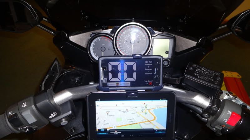
My setup w the Droid on top...

Picture20549_zps6579ef45.jpg


Not an iPhone of course, but maybe you can make/convert it to this. There is a thread about my GPS usage/mounting here.

 
Last edited by a moderator:
iPhones do NOT require cell coverage to work as full featured GPS units. In fact they are far superior to standard GPS units in many ways in my opinion
1). Can run multiple apps simultaneously (instead of only the native app on a dedicated GPS unit)

2). Is a phone - don't need an extra gadget

3). Lifeproof case makes them waterproof - much more compact than Aquaboxes

4). Can actually send tracks and locations out directly (this one does require cell connection)

5). If you've got an iPhone you don't have to spend much more $ - fee apps work, maybe you spend $20-30 for a better one. I use Navigon which is very nice

Power connectivity is a draw - anything running GPS chips drains quickly.

I used an iPhone last summer on a 4500 mile trip through the west, probably 90%+ of the time out of cell coverage and it performed flawlessly.
Sorry I'm a little late to the conversation, but I agree with Russ. If you buy a good GPS app an iPhone 5 is better than some of the cheaper GPS units. I have a Nuvi 1350 on a RAM mount and on my 3,300 mile trip down the east cost last fall I exclusively used my iPhone for navigation. I used MotionX app which is worth the money, speaks street names, and has support for multiple stops on routes, and plenty of options to find destinations. I kept my iPhone in an waterproof E-Case for smart phones and tucked it into my tank bag map pouch. Power was run from a powerlet plug installed on my left dash panel to the iPhone, which worked great!

As far as data, I didn't go over my 2Gig data plan with all that navigation and plenty of phone usage... a big help in that area is the fact MotionX will let you load your entire route into memory using WiFi. Each destination I would find a restaurant or coffee shop, stop for a break and load up my next long leg of the journey. That way you aren't using data packets while you're riding, just the GPS to find your position.

Yeah, I would like a Zumo... maybe someday, but until then my iPhone has been just fine. Glad you found a solution, looks pretty durable and waterproof! :)

 
iPhones do NOT require cell coverage to work as full featured GPS units. In fact they are far superior to standard GPS units in many ways in my opinion
1). Can run multiple apps simultaneously (instead of only the native app on a dedicated GPS unit)

2). Is a phone - don't need an extra gadget

3). Lifeproof case makes them waterproof - much more compact than Aquaboxes

4). Can actually send tracks and locations out directly (this one does require cell connection)

5). If you've got an iPhone you don't have to spend much more $ - fee apps work, maybe you spend $20-30 for a better one. I use Navigon which is very nice

Power connectivity is a draw - anything running GPS chips drains quickly.

I used an iPhone last summer on a 4500 mile trip through the west, probably 90%+ of the time out of cell coverage and it performed flawlessly.
Russperry- I have an iphone 4, do you know of any available GPS apps that allow custom routes to be generated and downloaded into the phone? I am currently using googlemaps as a point to point GPS on my phone.
I don't really know any way to do that. I've read on blogs that you can do some stuff requiring you to jailbreak your phone and do some file conversions but nothing that inspires much confidence.

 
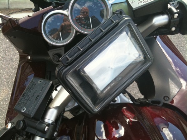
I have a Garmin 1790T in an AquaBox. It's powered off of a Powerlet outlet attached to the stem. If you go with custom power in the future (not using the plug and glove box), you'll likely need the special plug (Powerlet sells them) that tells the unit it's not hooked up for data, but rather power. Box is on a stem-mounted RAM mount and has worked well for the last couple of years. The only problem with low-rent GPS units is being able to see them in bright sunlight...I tried a Nuvi 360 at first and it was pretty much worthless in the sun; this 1790T has worked out much better.

Motion-X GPS is probably the best of the GPS apps for the iPhone IMHO; the data preload is a good feature when heading into areas with few data connections.

IMG_1189-e1302036046109.jpg


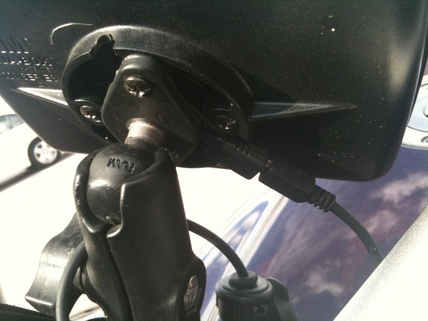
Special Garmin cable...

IMG_1191-e1302036138599.jpg


I have a Garmin 1790T in an AquaBox. It's powered off of a Powerlet outlet attached to the stem. If you go with custom power in the future (not using the plug and glove box), you'll likely need the special plug (Powerlet sells them) that tells the unit it's not hooked up for data, but rather power. Box is on a stem-mounted RAM mount and has worked well for the last couple of years. The only problem with low-rent GPS units is being able to see them in bright sunlight...I tried a Nuvi 360 at first and it was pretty much worthless in the sun; this 1790T has worked out much better.
Motion-X GPS is probably the best of the GPS apps for the iPhone IMHO; the data preload is a good feature when heading into areas with few data connections.
A couple interesting points for new users here:

- some of the older gps models are not usable when powered via usb port. Be sure to read the instructions to decide how to power it. You may be able to get a "special cord" for it- I was not and had to use a socket-type power source.

- some gps (like my garmin nuvi) are hard to read in the sun. I use this stick-on anti-glare stuff. It works great and I highly recommend it.

Newbies- as you can see there's lots of options with phones and gps's and whateverthehell. Don't get discouraged- just pick an idea and go with it. I'm more of a simplistic type o' guy so I just use the basic gps thing.

 
I've been using the iPhone 4 with Navigon GPS app. I'd use nothing but. Combined with the Scala G4, tunes, cell, turn by turn directions and intercom all in a compact package. Doesn't provide the cluttered cockpit like some of the FJR owners like.

Also find that when I don't use the GPS I'm using other GPS apps for a larger speedometer or to track where I've gone for the day, top speed, etc.

 
The only thing I really miss using my iPhone 5 and the Garmin GPS app is the ability to build and load custom custom routes. When reasonable I ride backroads by preference and this ususally requires a custom route.

 
The only thing I really miss using my iPhone 5 and the Garmin GPS app is the ability to build and load custom custom routes. When reasonable I ride backroads by preference and this ususally requires a custom route.
Other than finding info when I get there, custom routing is almost exclusively what I use my gps for.

 
I have been using an iPhone with the TomTom GPS app for a while now. I previously had a 3Gs and it worked great although a little slow loading. Now I have an iPhone 5 with the TomTom GPS and it loads fast and works absolutely great. I have been many places where there is NO cell coverages and it works great, all the maps are pre loaded so there is no downloading of maps while on the fly. I have it in a lifeProof case so I don't have to worry about it getting wet.

 
I have used my iphone 4s for about 12k miles. I use Navigon for the GPS app. That allows me to have a reliable GPS outside cellular signal. I have found an easy way to create custom routes without jailbreaking and I am using a 4Lock handlbar mount with a Ultimate Addons direct to battery charger. I currently have this in my FZ1, but I will be replicating it on the FJR.

Here's a post I wrote from another forum I am on carolinariders.com. This explains how I use google maps on a computer to make my route. You have to build extra destinations into your google route to force the GPS to take you preferred route. This will take some practice, but I am much faster at it now than I used to be.

"I have been trying to find a good easy way to use a GPS for turn by turn directions using custom routes.

I think I finally have an easy system to use. I had a complex system, but it really was a lot of trouble.

Here's what I have:

4Lock handlebar mount for iPhone with raincover

Ultimate add-ons direct to battery iphone charger

Navigon GPS App

and of course an iPhone. I use an iphone 4, but should work with any version with appropriate mount


Go to Google maps and plan your route. Make sure you add destinations to plan your route and not just waypoints or dragging the streets around. This will take a little practice, but you need to place the destinations strategically to make it go where you want it to. Navigon will see this route as a string of destinations.

Then save the route to "My Places". After you save it you will see a small link that says KML. Download that file.

Now download route converter here:
https://www.routeconverter.de/home/de

Open the KML file you just saved. (You could also build your route in this program)

After you open the KML, save the route as a Navigon URL. This will create a txt file with a link. You can copy this text and email it to yourself.

Now take your iPhone, that already has Navigon installed, and check your email. Click on the link and Navigon will open with the route you just planned.

Hit the little calculator icon at the top and go ride your custom route.

I took it a step further. I like to archive my routes and use them again later. I use dropbox on all my computers and iphone. This allows me an easy way to keep a few things synched between all my devices and allows for offline copies in case you lose your data connection.

I created a txt file that contained two navigon links. One to get there, and an oposite return route. Now I can use it over and over with ease.

I know this sounds like a long process, but it is really very easy.

If you guys know of something even better let me know, and I wil try it out."

 
I have used my iphone 4s for about 12k miles. I use Navigon for the GPS app. That allows me to have a reliable GPS outside cellular signal. I have found an easy way to create custom routes without jailbreaking and I am using a 4Lock handlbar mount with a Ultimate Addons direct to battery charger. I currently have this in my FZ1, but I will be replicating it on the FJR.

Here's a post I wrote from another forum I am on carolinariders.com. This explains how I use google maps on a computer to make my route. You have to build extra destinations into your google route to force the GPS to take you preferred route. This will take some practice, but I am much faster at it now than I used to be.

"I have been trying to find a good easy way to use a GPS for turn by turn directions using custom routes.

I think I finally have an easy system to use. I had a complex system, but it really was a lot of trouble.

Here's what I have:

4Lock handlebar mount for iPhone with raincover

Ultimate add-ons direct to battery iphone charger

Navigon GPS App

and of course an iPhone. I use an iphone 4, but should work with any version with appropriate mount

Go to Google maps and plan your route. Make sure you add destinations to plan your route and not just waypoints or dragging the streets around. This will take a little practice, but you need to place the destinations strategically to make it go where you want it to. Navigon will see this route as a string of destinations.

Then save the route to "My Places". After you save it you will see a small link that says KML. Download that file.

Now download route converter here:https://www.routeconverter.de/home/de

Open the KML file you just saved. (You could also build your route in this program)

After you open the KML, save the route as a Navigon URL. This will create a txt file with a link. You can copy this text and email it to yourself.

Now take your iPhone, that already has Navigon installed, and check your email. Click on the link and Navigon will open with the route you just planned.

Hit the little calculator icon at the top and go ride your custom route.

I took it a step further. I like to archive my routes and use them again later. I use dropbox on all my computers and iphone. This allows me an easy way to keep a few things synched between all my devices and allows for offline copies in case you lose your data connection.

I created a txt file that contained two navigon links. One to get there, and an oposite return route. Now I can use it over and over with ease.

I know this sounds like a long process, but it is really very easy.

If you guys know of something even better let me know, and I wil try it out."
Kaons bandit- Is the app called navigon USA for $39.99?
 
Top