Learn BaseCamp in one day

Yamaha FJR Motorcycle Forum

Help Support Yamaha FJR Motorcycle Forum:

This site may earn a commission from merchant affiliate links, including eBay, Amazon, and others.
I bet Mapsource would still work with a newer GPS. You just would not be able to take advantage of some of those "new features" that Tom mentions are in Basecamp. But, if you are using an "obsolete" GPS (like I am with my zumo 550's) then the new features in Basecamp don't work with the old GPS anyway, so sticking with Mapsource is fine.

The one big reason I'd like to learn to get used to Basecamp is that that Mapsource, in it's later incarnations, has a propensity for crashing in the middle of planning a large route. I've gotten used to saving my work often while using Mapsource so I won't lose too much if/when it does crash, but unfortunately that (those?) bugs will never get fixed by Garmin.

I have Ed's tutorial, and I have mucked around with Basecamp enough to know that, for mow, it is easier for me to just put up with Mapsource's crashing than learn the new program.

 
I bet Mapsource would still work with a newer GPS. You just would not be able to take advantage of some of those "new features" that Tom mentions are in Basecamp. But, if you are using an "obsolete" GPS (like I am with my zumo 550's) then the new features in Basecamp don't work with the old GPS anyway, so sticking with Mapsource is fine.
The one big reason I'd like to learn to get used to Basecamp is that that Mapsource, in it's later incarnations, has a propensity for crashing in the middle of planning a large route. I've gotten used to saving my work often while using Mapsource so I won't lose too much if/when it does crash, but unfortunately that (those?) bugs will never get fixed by Garmin.

I have Ed's tutorial, and I have mucked around with Basecamp enough to know that, for mow, it is easier for me to just put up with Mapsource's crashing than learn the new program.
Gee since Mapsourse does not crash on my PC then I am better off than Fred and he chooses Mapsource.

This means I am better off then Fred. This WILL never happen again. Cherish the moment!
smile.png


I'm actually really starting to like BaseCamp. It makes sense to me and I just taught it to myself a couple of years ago. I just printed Ed's Tutorial out - Kudos to Ed!!!.

There are a couple of things I want to compare his tutorial vs how I do things. This tutorial is wonderful and a very useful tool !

Thanks for taking the time to make it and share it!

-Iris

 
rbentnail - So you created all of the individual routes and then joined them to create a "master"?
Yes, that's sort of what I did. I created individual routes and joined together duplicates of them to create an overall master.

I sort of wanted to look at the whole thing so I might be able to optimize routing (order etc.) and then break it up into the "day" or more likely "region" sub routes. The "Big Picture" is likely to be helpful for general planning as opposed to small(er) sections; at least until I know the optimum order for the planned stops. Once I see the total distance and/or riding time for the Master, I can quickly decide where I may need to edit to make this somewhat ambitious trip possible. Break it up into manageable sections once the trip is planned.
I expect things will become clearer after I delve into it (and make a bunch of mistakes along the way)!
I'm being told I can create an overall 'master' then break it up into shorter sections but I've yet to figure out how to do that.

 
I'm actually really starting to like BaseCamp. It makes sense to me and I just taught it to myself a couple of years ago. I just printed Ed's Tutorial out - Kudos to Ed!!!.There are a couple of things I want to compare his tutorial vs how I do things. This tutorial is wonderful and a very useful tool !

Thanks for taking the time to make it and share it!

-Iris
My pleasure Iris

 
Thanks Tom. I sort of figured that the process would become clearer as I did the tutorial. I would, however, like to have a master route (on the computer, not the GPS) so I have the "Big Picture" of the trip. It will help me determine some routing logistics and help determine what, if any, sections that may have to be trimmed. Pretty sure the whole route would crash the Zumo in short order!
Long routes can easily be broken up using the divide tool.

 
How about do the route planning with TYRE and import the track in Basecamp. TYRE using Google Maps drag the line around route adjustments. It's clunky switching between apps but it sometimes is easier.

 
I am getting there. The tutorial and some of this discussion have been most helpful - thanks Ed.

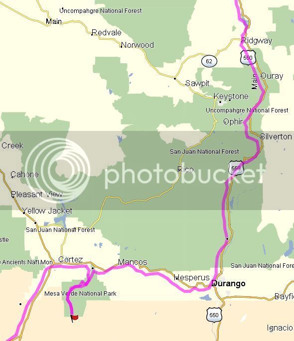
I am noticing that the colored lines are often not right on the selected roads. They may run parallel but, in many cases, off to one side or the other. If you zoom in, it is clear that it hasn't chosen the wrong road but it is a bit confusing at times. Does anyone else see this or is there something wrong with my installation/setup. Screen Snip below.


I am getting there. The tutorial and some of this discussion have been most helpful - thanks Ed.
I am noticing that the colored lines are often not right on the selected roads. They may run parallel but, in many cases, off to one side or the other. If you zoom in, it is clear that it hasn't chosen the wrong road but it is a bit confusing at times. Does anyone else see this or is there something wrong with my installation/setup. Screen Snip below.

1) Make sure that you have the same map version on both BaseCamp and your GPS

2) Recalculate your route as discussed in the Agenda

 
Same map version on both but this shouldn't matter since this is only on the computer. Using latest Basecamp and latest maps. This is over the entire long route. I will try a recalculate tonight when I get home although this happened as the route was originally created. From your comments, I assume that this isn't normal.

 
Same map version on both but this shouldn't matter since this is only on the computer. Using latest Basecamp and latest maps. This is over the entire long route. I will try a recalculate tonight when I get home although this happened as the route was originally created. From your comments, I assume that this isn't normal.
Recalculate then. Use Faster Time

 
No, that's not the problem here.

What Ross has done is to place his shaping points from too high an altitude (zoomed out too far) and the points are now on side roads that are not seen due to the altitude and/or detail level setting.

If you zoom in far enough you will see what other roads those points are actually located on (may even be unpaved!) and can then move the shaping points to the road that you actually want (assuming you are wanting to be on US 550).

PS - I had a chance to play with Basecamp and the tutorial last week, and I'm also getting it. I think I could now live with the folder structure after the tutorial (Thanks, Ed!), but most of the routing features still work much better and easier for me in Mapsucks.

 
Last edited by a moderator:
Fred, I originally thought that might be the case but when I zoom in as far as I can, the route line is still on (or next to) the desired road. There are no side roads that appear and there is no question that I have the right road. I am seeing this over the entire route; even in places where there is only ONE road.

I will go back and check the settings and perform a recalculate on the offending routes. If that doesn't work, I will try uploading and see if there are any issues on the Zumo.

 
I have never seen the dots (and route) off the side of the road like that. Can you post a screen capture zoomed in on the shaping point?

 
I have never seen the dots (and route) off the side of the road like that. Can you post a screen capture zoomed in on the shaping point?
I will have another look at it tonight. Maybe I made an error in the setup although I'm pretty sure I did Motorcycling and Fastest route - perhaps I accidently changed something when I did some playing around with settings. (I was pretty tired when I was working on this last night) Dragging a route (inserting a shaping point) shouldn't have to be precise when there are no other possible roads. I would expect it to "snap" to the closest road. I will check and post back. Perhaps Basecamp thinks I am walking...
Re-check your Motorcycle profile, the parameters for each/any profile are editable, so even Motorcycle could be offset and let's say more-so replicate another profile and if you re-calculate between them.... no diff.

On the re-calculate. Sometimes to get it (BC to Route) to "wake-up" simply by recalculating between 2 "different" profiles.
wink.png
Also, make your map in BC with your GPS connected, this way it will take/use the newer mapset off your GPS and load it on your computers BC screen... this process takes a few minutes for BC to pickup/recognize this once USB'd up.

......

On your image (map). I looked at my mapset/BC (NA 2015.40) and didn't see a mirrored road like that even close to 550. So, with that assumption, I believe your profile (that you re-calculated to) is trying to "not" use roads but rather off-road or hiking perhaps. Of course with an image shot and not seeing the BC itself, we are all guessing, and this is simply my .02
smile.png


Last edited by a moderator:
Dragging a route (inserting a shaping point) shouldn't have to be precise when there are no other possible roads. I would expect it to "snap" to the closest road. I will check and post back. Perhaps Basecamp thinks I am walking...
This is one of the things we have to get used to with BC- you DO have to be precise when picking points. Remember, BC is designed for off-road stuff too so regardless of what profile you choose BC will send you to the precise place you pick. There is no "snap" feature so you must pick your points very carefully.

I second the "connect your gps..." statement. Most of my frustrations went away when I connected my gps to my computer and re-installed/updated my maps on both. They both said CN2015.40 but for some reason didn't play well together. Updating them of course takes hrs but made the straight line routing, the off-road routing and several other problems go away.

 
Last edited by a moderator:
The more I zoom in, the closer (in actual distance) the line comes to the road. Zoomed out, the colored line might vary up to a mile from the actual road but if zoomed in all the way, it will only be tens of feet so its not a "hard" location. From here (work), I can only guess but if others aren't getting this, I may have messed up the profile somehow. Will check it tonight. BTW, I have the same (current) mapset on both computer and GPS.

 
I think you'll find the route works in the GPS, and may align with the roads with a restart. The misalignment of a route with roads seems to be an artifact from an overloaded graphics buffer. I have seen it before, and restarting BaseCamp usually fixes it.

 
Top