No more Zumo 660, no more Garmin

Yamaha FJR Motorcycle Forum

Help Support Yamaha FJR Motorcycle Forum:

This site may earn a commission from merchant affiliate links, including eBay, Amazon, and others.
AdamK wrote:

I do store a LARGE quantity of mp3s on my gps SD card. That is an appropriate use of SD storage. The streaming of music won't be effected by the slower SD memory access speeds. I did have locking up issues when I had thousands of mp3s stored in folders which was the result of copying them directly from my home audio system drive. I have over 1TB of music stored in a DIR hierarchy of \band\album\mp3 structure. The Garmin chocked on the DIR structure. After simply dumping the mps3 in a common folder those lockups ceased. I'm figuring these issues were attributed to the length of the path\filenames exceeding a coding limit in the media player.
That's interesting. I had read in the Zumo forum (now extinct) that the better way to structure mp3 files was the way you said you had problems with. So my mp3 are setup that way and I've not had any major problems.

I did have my 660 spontaneously reboot while playing music and finally determined that there was a corrupted song causing this problem. Deleted that song and no problems since.

I do occasionally get stuttering during a song that might be a memory issue (like there's a repeated delay in loading the next part of the song). After stopping music play for a while, I restart the song and it works fine. Maybe I need to try dumping all files in a common folder to see if that helps?

 
AdamK wrote:

I do store a LARGE quantity of mp3s on my gps SD card. That is an appropriate use of SD storage. The streaming of music won't be effected by the slower SD memory access speeds. I did have locking up issues when I had thousands of mp3s stored in folders which was the result of copying them directly from my home audio system drive. I have over 1TB of music stored in a DIR hierarchy of \band\album\mp3 structure. The Garmin chocked on the DIR structure. After simply dumping the mps3 in a common folder those lockups ceased. I'm figuring these issues were attributed to the length of the path\filenames exceeding a coding limit in the media player.
That's interesting. I had read in the Zumo forum (now extinct) that the better way to structure mp3 files was the way you said you had problems with. So my mp3 are setup that way and I've not had any major problems.
Well, I guess I should say I <really> don't know the exact cause. What I do know is I had thousands of songs on the SD. They were stored in \band\album\track format. There was also a single folder.jpg album cover graphic in each DIR. After repeated lockups or reboots I simply moved everything into a single DIR and removed the .jpg files. No problems since. I figured it wasn't the jpg files since they were in every DIR to begin with and I would have thought they would cause an issue straight away. So I attributed it to the length of the DIR structures. Who knows for sure.....

 
Dunno how I missed that. I suppose I could have gone the phone to 660 route. I did that (HFP to headset) and it was ...what?... cumbersome. Anyway, the issue's moot now that I have the TT Rider 550.

 
The 660 is only marginally harder to remove. Gotta find the little pushbutton thingie and then... bye bye. And no way to lock the mount, unlike the 550.
If the mount is similar to the 590, I made a mounting plate with a small tab for a "luggage lock".

With the lock installed, you cannot push the release (you'd have to destroy the GPS to get it off).


Garmin tech support was very pleasant to deal with for me. They couldnt fix anything and didnt seem that knowledgeable about my gps, but they were very nice. I still have the device. It still does everything its supposed to do about 20% of the time.

 
I've used nearly everything Garmin have made in the last 15 years and more than 250,000 miles. No matter what the fanboys say, one thing is absolutely for sure, Garmin routing has gotten progressively worse in that time and is now the worst it has ever been. My 590 and 390 do stupid stuff regularly. I've used loads of Tomtoms too, currently a 450, they are not as intuitive or convenient as Garmin but they will route you from A to B reliably.

 
Biquer posted, in part: ... they will route you from A to B reliably.
First, let me get the humour out of my system: Love your screen name, and pronounce it with a French accent just to piss you off, Irish brother: bee-CARE.

.................................................................................................................

There are two requirements for a motorcycle navigation system:

1) Does it get you from A to B reliably and without stupid or inefficient routing choices?

2) Can it store and recite turn-by-turn directions for a purposefully inefficient route -- a scenic or twisty route for example, or a loop beginning and ending at your house?

I gave up on Garmin when it failed at Task 1 for the sixth or seventh time. During touring rallies like the Tour of Honor or the Big Money Rally, route inefficiencies can add a lot of miles into your day.

Sometimes that means you're riding home after a cold sunset, and that's only funny the first time it happens.

 
Last edited by a moderator:
You've hit reasons I gave on Garmin. If the thing can't go from A to B without going by way of Sandusky, it's flunked its primary reason for existing. All the nice GUI, etc. is meaningless.

I'm still working on getting acquainted with the 550. There are Garmin features I miss. Some of them are too "WTF is this?". For example, there is no elevation data available anywhere. None. Don't even ask. There is a pair of trip statistics displays - thin on data, but the basics are there. What's missing is a way to reset either. Well, yes, there is a way. Do a full on Factory Data Reset. As I said to support "That's like burning the house to get rid of mice". Street announcments are a bit odd "Turn left in 500 feet. Main Street". Map displays are heading up, heading up, or heading up. North up? Nah. There is a near useless N, NE, E, SE... display box.

There's a curious "thermometer" display, on the side of the screen, for any route. The start is at the bottom, the destination is at the top, and I guess the cursor says"you're about x far down the road. It's uncalibrated (no miles ticks) and mostly a waste of screen real estate.

Routing seems to be OK. I'm currently in Germany and expect to take some trips featuring some twists and turns to get from A to B. We'll see how it goes.

 
... There is a pair of trip statistics displays - thin on data, but the basics are there. What's missing is a way to reset either. Well, yes, there is a way. Do a full on Factory Data Reset. ...
There are three pages of statistics, "Today", "Since date" and "All-Time".
"Today" is what it says, so resets every midnight, "Since date" has a "Clear trip" button, so can be reset whenever you want. It's only "All-Time" that would need a factory reset to clear - which, by its title, sounds reasonable.

 
Well slap me silly and call me Sally... I took that date to be associated with the "All time" display. Arghhh
banghead.gif


Tell me altitude data can be displayed, and I'll call you a 550 Zen Master.
thumbsupsmileyanim.gif


Well slap me silly and call me Sally... I took that date to be associated with the "All time" display. Arghhh :banghead:
Tell me altitude data can be displayed, and I'll call you a 550 Zen Master. :thumbsupsmileyanim:
Sorry, no can do. My Zen status remains unchanged.
Tomtom have never done altitude in their Riders. Seems silly, the info is available from the GPS engine. At least they now record time when you track yourself, which they used not to.

 
It's odd that there's no obvious support for altitude. I raised this issue on the TT Rider forum.

I agree that any GPS engine worth its name has altitude as part of its data as part of the process of getting a fix. [/ insert: comments about GPS systems using localized data about the earth's shape (loosely, pear-shaped)and its relation to a fully correct fix]

I haven't looked into it, but how is trip data made available for video overlays? If at all?

You still get elevation in the Zen hierarchy for knowing anything about this subject. ;)

 
...I haven't looked into it, but how is trip data made available for video overlays? If at all?

You still get elevation in the Zen hierarchy for knowing anything about this subject. ;)
I don't know how you are supposed to get overlays. What I currently do, to get my tracked routes onto a map, is to "share" a track (a GPX file) to an SD card, use that to copy it to my computer. I then convert the GPX file to a suitable CSV file that can be uploaded to Google Drive, and Google will provide a link to an interactive map with all the data points on it. You can see some of my tracks on my web site here (as of this date there are none from the 550 that I've published, but I have tested it).
My old Rider would record occasional points, I think it took into account speed and distance to record points at a sensible interval. The 550 records every second, so I added an algorithm to do my own data reduction.

This is all a bit "knife-and-forked", with the major down-side that Google are withdrawing the facility sometime next year. Don't know what to do after that.

I feel my Zen hierarchy elevation going down :( .

 
Last edited by a moderator:
I'll do some sniffing around to see what's available to play with. This one of the cases that illustrates "Standards are wonderful. There are so many to choose from."

Have a good zazen.

 
Cross-posting and possibly (probably?) repeating myself...

I've had some time to live with the Rider 550. Long list of stuff follows:

I'm inclined to think corporate TomTom is, in its own way, about like Garmin to deal with. Specifically, there;s a user forum for TT products. Responses from TT support are ...ah... rare. There is only one way to get traffic and weather info to the 550: through the MyDrive app, which must be set to exchange anonymous (or is claimed) use info. More about MyDrive below. For some reason, the 550 doesn't display elevation data although it's inherent in all GPS fixes. Getting TT to at least actively look into this is... crickets, nothing but crickets. While the 550 supports a wide range of languages in voice prompts, very few languages included speak street names. Again, no comment from TT about this (even if it's just "we can't keep things correct" or whatever).

The MyDrive app, is needed to manage a BT link between the 550 and phone (phone then moves data in or out via its connection to the Internet). Pairing directly between the 550 and phone is a waste of time; the 550 won't move data through the pathway. MyDrive must have notification permission, access to the phone (of course), messaging (of course), and BT data transfer (of course). But if the user doesn't want to send anonymous usage data, traffic reporting, weather reporting, and avoidance aren't sent to the 550. In short, the user is coerced into using core features. But wait, it gets worse.

MyDrive under Android (I don't have iOS experience) is a major battery drain. And it can't be turned off or put into sleep mode. It launches at boot-up and stays there, even if the 550 is not even vaguely in range for the BT link. If MyDrive's on a phone and the 550 won't be used until the next weekend, tough. It's still there, draining the battery at a very high rate. There are two cures: uninstall the app (app-killing/stopping apps or settings do not work - MyDrive is "The App That Won't Die") or have a rooted phone capable of running Titanium backup app. The first route's obvious. The second route (no pun intended) is limited to a very small group. Rooting is never something for casual users - get it wrong and the phone can be bricked. Additionally, a large number of phones can't be rooted (thank you, US wireless company monopoly). Rooting is not the same as unlocking, BTW. However, Titanium can "freeze" almost any app (freeze the wrong app and the phone dies) including MyDrive. Reboot after freezing it and MyDrive ceases to exit until it's "thawed".

Attempts get TT to be a little(!) more user friendly, by adding an on/off option... crickets, nothing but crickets.

That's the bad news

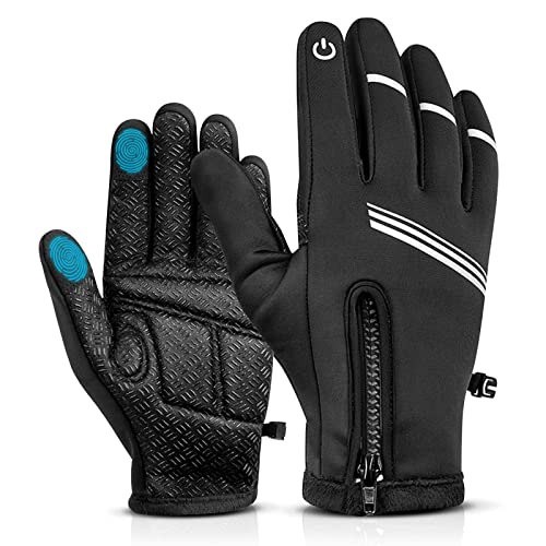
The good news: This thing screams through data with a four core processor. The screen imagery is crisp (but why, why, why a glossy, sun-reflecting surface???). The touch sensitivity can be changed to allow use while wearing gloves(!). The type-in "keyboard" can be configured for bare fingers or clumsy gloves. The internal WiFi capability means there is no need for a wire connection to a PC for updates. TT recommends having power supplied to the 550 while updating.

For some reason, I couldn't sort out the "what maps and how much" and "how much for traffic" points. The answer is buying the 550 gives lifetime updates to what amounts to global mapping. Including "Oceana" which, I guess, means islands everywhere???. The full Europe map set and North America map set won't fit into the phone simultaneously. TT gives a good collection of European map subsets. Or the NA maps can be pulled to make room for all of Europe. Pull that set to make room for another set without worrying about "we gave you some maps and you tossed them? No reload for you". Traffic and weather data support is also a lifetime feature. The POI info is updated regularly.

Figuring out the on-board routing and other menu items is easier for anyone who hasn't used any GPS at all. For anyone else, there's a learning curve to undo old habits.

One the things I used to curse Garmin about is the voice prompts, via BT to a headset, were screamingly loud, with no volume control. Jump over this section if you don't care about BT and headsets. First, it turns out that the 660's link to the headset was only via HFP (hands free protocol - a BT protocol that's good for simple voice and minimal control activity). HFP is why MP3 playback on the Garmin 660 is so lame; it was never meant for music, ever. Also, HFP means any sound moved of an HFP link will always be EFFIN' LOUD!!

The TT 550 offers a work-around. The headset/intercom must support two BT links (not all do - Sena 20S and 20S EVO do, for example). Step one is pair the phone the headset. It's almost certain the link will use A2DP (the "hi-fi" link). Step two, pair the 550 and phone. Again this is almost certain to use A2DP. Step three is to pair the 550 with the headset. This is the place where the protocol is the 550 user's choice - use A2DP. With at least the Sena, music from the phone will be squelched or dropped under voice and beeps from the 550. Yea! There's still no volume control. Sorta. With the headset off (stops BT link), use the 550 volume control for speaker mode. Dropping to 20-30% should work. Turn the headset back on (BT between phone, headset, and 550) and the 550's volume is reduced! Woohoo! The 550 is that flexible.

The mount supplied with the 550 is a motorcycle mount with a RAM Mount ball on it. I have a RAM Mount mounting place design to replace the brake or clutch master cylinder. A short "dog bone" holds things together and allows positioning. The mount includes a two lead "pig tail" long enough to reach most batteries/distro boxes. The 550/mount interface is far more secure than the 660's. If the 550 pops off the mount it's because it was never put on correctly. The 550 must go downwards to lock, and can only unlock by pulling back a tab and sliding up. An add-on security lock (covers the release tab) is available for a silly price. Remove the 550 and hide it somewhere safe. There is also a car, suction cup windshield mount. It's got a clever way to get full suction. Plug a USB cable into the back and run it to a power point adapter. The adapter must have 2.4A capacity to keep the battery charging during use. The 1.1A port doesn't keep the battery "fed" during use.

Bottom line: would I buy it again? Yes. But I'd be more aware that TT doesn't listen well. The phone app is a necessary evil and PITA - without it not much useful happens. Drat.

 
Minor comment: the reason road names are only available with a couple of voices is because these are the computer generated voices, so TT can read the road names from the database and speak them (with occasionally hilarious pronunciation). Road name recordings (in all voices) would require significantly larger databases.

 
IMHO some main languages - e.g., English, French, Spanish, German, should cover much of the world. As it is, listening to Samantha talking about heading to Wheeze-baden (instead of veesBADen for the German city Wiesbaden) evoked outright laughter from the in-laws. If nothing else, pick a few voices from a library of common languages and call it good. My French is abysmal, my Spanish marginally better, Danish, Swedish, Norwegian non-existent. Load up German and English (pick one); life is good and memory space is conserved.

At least for me, doing running translations from Samantha to German street signs, etc. is one more task on top of the business of driving and giving the GPS at least marginal attention. Avoiding task saturation (too many tasks to the point where some are totally lost) is a Good Thing.

Oder so siehts aus für mich. ;)

 
Heres more to think of..

BaseCamp discontinued

https://support.garm...dRB1DDl1JAWuEV8

Not sure if I'm just happy or ecstatic!

SNAP! Must have one of few Garmin devices to use Explore.

https://explore.garm...ount/GarminUser

Garmin at its finest moments...

https://www.fjrforum.com/forum//public/style_emoticons/default/****.gif Garmin

OR on your mobile device via Garmin Explore App


Top